Standardised Drone Procedures for Phytosociological Data Collection
Abstract
Aims
Phytosociological maps are crucial for biodiversity conservation. Supervised mapping with machine learning demands high-quality reference data that field surveys alone cannot provide. This study evaluates drone-based procedures for phytosociological data collection, comparing them with field surveys. The research questions are as follows: Are species abundance data collected via drone surveys consistent with those obtained through traditional field phytosociological methods? Can plots be correctly assigned to known plant communities using drone data?
Location
Marche, Central Italy.
Methods
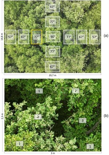
Drone surveys were conducted over forest and grassland plots using tailored imaging protocols. Forest plots were captured at 14 m with 11 high-zoom images per plot, while grasslands were surveyed at 5 m with seven images per plot. The images were analysed to identify plant species and estimate their abundances, generating plot × species matrices. Multivariate analyses, including PCA, Mantel tests and supervised k-means classification, were used to compare drone data with those obtained from the field traditional method.
Results
PCA and Mantel test results (r = 0.782, p < 0.001) demonstrated a strong relationship between species abundance data collected by drone and traditional field methods in both forest and grassland. The supervised classification achieved an overall accuracy exceeding 90% in assigning drone-surveyed plots to predefined plant associations.
Conclusions
This study introduces the proposal of standardised drone procedures to assist botanists in collecting phytosociological data in sub-Mediterranean grasslands and forests. They can effectively complement and enhance the traditional Braun-Blanquet method, broadening its scope and efficiently performing tasks such as vegetation unit assignment and creating reference data useful for the continuous production of supervised phytosociological maps of vegetation and habitats, which are essential for environmental monitoring.
 求助内容:
求助内容: 应助结果提醒方式:


