{"title":"Determination of depth to basement using natural electric field method (NEFM) in a proposed weir at Iju-Itaogbolu, SW Nigeria","authors":"Philomina Nkeonye Okanigbuan , Edore Festus Omozeje , Oluwatoyin Francis Ijasan , Uyiosa Osagie Aigbe","doi":"10.1016/j.geogeo.2025.100403","DOIUrl":null,"url":null,"abstract":"<div><div>Natural electric field traverses (3) consisting of eighteen (18) VEMs points in each traverse 1 m apart were conducted across the proposed weir axis at Ogbesse River in the Iju-Itaogbolu area, to determine the thickness of overburden materials and depth to bed rock at the proposed weir site. Field investigations were conducted using the PQWT GT 500 series. Results revealed five (5) geo-electric layers with varying thickness in place, which included the topsoil, clayey unit, sand unit, and significantly weathered and fractured basement. The result also showed the presence of alluvium deposits in the area which is approximately 118 m² and varies between 3 and 18 m beneath the study area. The average thickness and saturation of the subsurface materials are particularly significant, with consequences leaning toward a high permeability of the sandy layer below the clay bed which has been partly exposed at the surface in the south-eastern section of the proposed weir axis. The proposed weir axis exhibited a regolith thickness ranging from 3.86 to 16.22 m, notably fractured at shallow and deep sections. These characteristics were observed across the proposed weir axis, increasing in magnitude and numbers upstream of the proposed weir axis. The conductivity of these fractured zones is indicative of a significant saturation. Depth to bed rock and thickness of overburden materials in the study area is however not uniform as observed from the results, indicating the fairly undulating surface of the bed rock in the study area. This study has provided useful information on the cause of failure experienced in the previous weir located 100 m upstream of the proposed weir in the past.</div></div>","PeriodicalId":100582,"journal":{"name":"Geosystems and Geoenvironment","volume":"4 3","pages":"Article 100403"},"PeriodicalIF":0.0000,"publicationDate":"2025-05-02","publicationTypes":"Journal Article","fieldsOfStudy":null,"isOpenAccess":false,"openAccessPdf":"","citationCount":"0","resultStr":null,"platform":"Semanticscholar","paperid":null,"PeriodicalName":"Geosystems and Geoenvironment","FirstCategoryId":"1085","ListUrlMain":"https://www.sciencedirect.com/science/article/pii/S2772883825000536","RegionNum":0,"RegionCategory":null,"ArticlePicture":[],"TitleCN":null,"AbstractTextCN":null,"PMCID":null,"EPubDate":"","PubModel":"","JCR":"","JCRName":"","Score":null,"Total":0}
引用次数: 0
Abstract
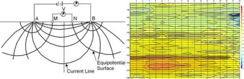
Natural electric field traverses (3) consisting of eighteen (18) VEMs points in each traverse 1 m apart were conducted across the proposed weir axis at Ogbesse River in the Iju-Itaogbolu area, to determine the thickness of overburden materials and depth to bed rock at the proposed weir site. Field investigations were conducted using the PQWT GT 500 series. Results revealed five (5) geo-electric layers with varying thickness in place, which included the topsoil, clayey unit, sand unit, and significantly weathered and fractured basement. The result also showed the presence of alluvium deposits in the area which is approximately 118 m² and varies between 3 and 18 m beneath the study area. The average thickness and saturation of the subsurface materials are particularly significant, with consequences leaning toward a high permeability of the sandy layer below the clay bed which has been partly exposed at the surface in the south-eastern section of the proposed weir axis. The proposed weir axis exhibited a regolith thickness ranging from 3.86 to 16.22 m, notably fractured at shallow and deep sections. These characteristics were observed across the proposed weir axis, increasing in magnitude and numbers upstream of the proposed weir axis. The conductivity of these fractured zones is indicative of a significant saturation. Depth to bed rock and thickness of overburden materials in the study area is however not uniform as observed from the results, indicating the fairly undulating surface of the bed rock in the study area. This study has provided useful information on the cause of failure experienced in the previous weir located 100 m upstream of the proposed weir in the past.

 求助内容:
求助内容: 应助结果提醒方式:


