{"title":"Rapid Flood Inundation Mapping for Effective Management: A Machine Learning and Pixel-Based Classification Approach in Feni District, Bangladesh","authors":"Kabir Uddin, Sazzad Hossain, Birendra Bajracharya, Bayes Ahmed, Md. Khairul Islam","doi":"10.1111/jfr3.70087","DOIUrl":null,"url":null,"abstract":"<p>In Bangladesh, where floods frequently occur, there is a severe annual risk to community displacement, agriculture, fisheries, livestock, public health, and food security. Extreme flooding events are becoming more common due to a combination of human-induced climate change, irregular upstream river water flows, increased proportion of sediment distribution on the riverbed, institutional fragility, lack of planning regulations, and changing rainfall patterns. Effective flood management requires precise and timely flood mapping methodologies to adopt disaster risk reduction strategies and enable efficient response efforts. This study presents an approach that facilitates timely flood identification, improving emergency response, evacuation initiatives, relief distribution, and disaster risk reduction. This research introduces a novel methodology for expedited flood inundation mapping, using the August 2022, 2023, and especially the 2024 flood events in the Feni District as the primary case study. The study employs Google Earth Engine (GEE) and Sentinel-1 synthetic aperture radar (SAR) data to accurately delineate flood inundation regions by utilizing vertical transmit and vertical receive (VV), vertical transmit and horizontal receive (VH), and VV/VH polarization bands. Water bodies characterized by lower backscatter values in VH polarization ranging from −41.15 to −24.06 dB and VV polarization from −31.66 to −15.94 dB were identified as suitable thresholds for flood inundation area delineation. To assess the accuracy of flood map, this study focuses on pixel-based digital classification and machine learning (ML) techniques separately for flood inundation mapping. The classification accuracy values of 95.60% for the pixel-based method and 94.40% for the random forest ML model specifically correspond to the 2024 flood event. This study developed a GEE-based operational methodology by evaluating two innovative techniques designed for rapid flood inundation mapping to support effective flood management and disaster risk reduction efforts.</p>","PeriodicalId":49294,"journal":{"name":"Journal of Flood Risk Management","volume":"18 2","pages":""},"PeriodicalIF":3.0000,"publicationDate":"2025-06-15","publicationTypes":"Journal Article","fieldsOfStudy":null,"isOpenAccess":false,"openAccessPdf":"https://onlinelibrary.wiley.com/doi/epdf/10.1111/jfr3.70087","citationCount":"0","resultStr":null,"platform":"Semanticscholar","paperid":null,"PeriodicalName":"Journal of Flood Risk Management","FirstCategoryId":"93","ListUrlMain":"https://onlinelibrary.wiley.com/doi/10.1111/jfr3.70087","RegionNum":3,"RegionCategory":"环境科学与生态学","ArticlePicture":[],"TitleCN":null,"AbstractTextCN":null,"PMCID":null,"EPubDate":"","PubModel":"","JCR":"Q2","JCRName":"ENVIRONMENTAL SCIENCES","Score":null,"Total":0}
引用次数: 0
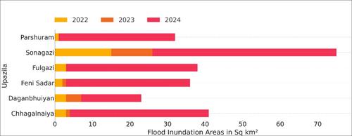
Abstract
In Bangladesh, where floods frequently occur, there is a severe annual risk to community displacement, agriculture, fisheries, livestock, public health, and food security. Extreme flooding events are becoming more common due to a combination of human-induced climate change, irregular upstream river water flows, increased proportion of sediment distribution on the riverbed, institutional fragility, lack of planning regulations, and changing rainfall patterns. Effective flood management requires precise and timely flood mapping methodologies to adopt disaster risk reduction strategies and enable efficient response efforts. This study presents an approach that facilitates timely flood identification, improving emergency response, evacuation initiatives, relief distribution, and disaster risk reduction. This research introduces a novel methodology for expedited flood inundation mapping, using the August 2022, 2023, and especially the 2024 flood events in the Feni District as the primary case study. The study employs Google Earth Engine (GEE) and Sentinel-1 synthetic aperture radar (SAR) data to accurately delineate flood inundation regions by utilizing vertical transmit and vertical receive (VV), vertical transmit and horizontal receive (VH), and VV/VH polarization bands. Water bodies characterized by lower backscatter values in VH polarization ranging from −41.15 to −24.06 dB and VV polarization from −31.66 to −15.94 dB were identified as suitable thresholds for flood inundation area delineation. To assess the accuracy of flood map, this study focuses on pixel-based digital classification and machine learning (ML) techniques separately for flood inundation mapping. The classification accuracy values of 95.60% for the pixel-based method and 94.40% for the random forest ML model specifically correspond to the 2024 flood event. This study developed a GEE-based operational methodology by evaluating two innovative techniques designed for rapid flood inundation mapping to support effective flood management and disaster risk reduction efforts.
期刊介绍:
Journal of Flood Risk Management provides an international platform for knowledge sharing in all areas related to flood risk. Its explicit aim is to disseminate ideas across the range of disciplines where flood related research is carried out and it provides content ranging from leading edge academic papers to applied content with the practitioner in mind.
Readers and authors come from a wide background and include hydrologists, meteorologists, geographers, geomorphologists, conservationists, civil engineers, social scientists, policy makers, insurers and practitioners. They share an interest in managing the complex interactions between the many skills and disciplines that underpin the management of flood risk across the world.

 求助内容:
求助内容: 应助结果提醒方式:


