Geospatial analysis of soil salinity dynamics: Exploring topographic and vegetation influences in coastal Bangladesh
引用次数: 0
Abstract
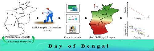
Soil salinity is a critical environmental challenge within coastal systems, posing a significant threat to vegetation in the territory. This study investigates the spatial distribution of soil salinity in coastal Bangladesh and its relationships with topography and vegetation indices. Seventy-five soil samples (0–15 cm depth) were collected using a stratified random sampling method. Moisture content, electrical conductivity (EC), pH, and temperature were all measured utilizing electrical sensor-based optimized tools. Topographic parameters including elevation, slope, aspect, and topographic wetness index (TWI), were derived from the Digital Elevation Model (DEM) using ArcGIS. Sentinel-2A imagery was utilized to analyze salinity–vegetation interactions through spectral indices such as CRSI, GARI, NDVI, GNDVI, GDVI, and NDI. Results showed that soil salinity ranged from 0.68 to 25.88 dS/m, averaging 6.08 dS/m. A strong positive correlation was observed between soil moisture and salinity (r = 0.87). Hotspot analysis revealed the southern region as a salinity hotspot, indicating a north-to-south increasing salinity gradient. Furthermore, linear regression showed a strong negative relationship between elevation and salinity (R² = 0.91) in regions above 15 m, while slope, aspect, and TWI were insignificant. Vegetation indices, NDVI, and CRSI demonstrated moderate negative correlations with salinity, indicating that higher salinity leads to lower plant health. This study underscores the pivotal influence of topography, especially elevation, on soil salinity distribution and demonstrates the effectiveness of vegetation indices for salinity monitoring. These findings support the use of precision agriculture and informed land-use planning to enhance sustainability and resilience in Bangladesh’s salinity-affected coastal regions.
土壤盐度动态的地理空间分析:探索孟加拉国沿海地形和植被的影响
土壤盐碱化是沿海系统面临的严峻环境挑战,对该地区的植被构成重大威胁。本文研究了孟加拉国沿海地区土壤盐分的空间分布及其与地形和植被指数的关系。采用分层随机抽样法,收集深度为0 ~ 15 cm的土壤样品75份。水分含量、电导率(EC)、pH值和温度都是利用基于电子传感器的优化工具测量的。地形参数包括高程、坡度、坡向和地形湿度指数(TWI),由ArcGIS利用数字高程模型(DEM)得到。利用Sentinel-2A影像,通过CRSI、GARI、NDVI、GNDVI、GDVI和NDI等光谱指数分析盐度与植被的相互作用。结果表明:土壤盐度变化范围为0.68 ~ 25.88 dS/m,平均为6.08 dS/m;土壤湿度与土壤盐分呈显著正相关(r = 0.87)。热点分析显示南部地区为盐度热点,盐度梯度呈南北递增趋势。在15 m以上区域,海拔与盐度呈显著负相关(R²= 0.91),坡度、坡向和TWI不显著。植被指数、NDVI和CRSI与盐度呈中等负相关,表明盐度升高导致植物健康水平降低。该研究强调了地形,特别是海拔对土壤盐分分布的关键影响,并证明了植被指数对盐分监测的有效性。这些发现支持在孟加拉国受盐碱化影响的沿海地区采用精准农业和明智的土地利用规划来提高可持续性和抗灾能力。
本文章由计算机程序翻译,如有差异,请以英文原文为准。
求助全文
约1分钟内获得全文
求助全文

 求助内容:
求助内容: 应助结果提醒方式:


