Assessing Groundwater Potential in the Ziway Lake Watershed Using Geographical Information System, Analytic Hierarchy Process, and Drinking Water Quality Index
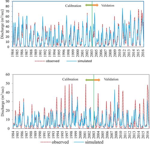
{"title":"Assessing Groundwater Potential in the Ziway Lake Watershed Using Geographical Information System, Analytic Hierarchy Process, and Drinking Water Quality Index","authors":"Tariku Takele, Abraham Mechal, Berihu Abadi Berhe","doi":"10.1002/gch2.202400354","DOIUrl":null,"url":null,"abstract":"<p>This study investigates the groundwater potential zones in the Ziway Lake watershed of Ethiopia's rift valley using a GIS-based multi-criteria decision analysis within the Analytical Hierarchy Process (AHP). Environmental factors, including recharge, lithology, elevation, lineament density, and drainage density, are analyzed. The soil and water assessment tool (SWAT) model is applied to estimate groundwater recharge for the watershed. The performance of the SWAT model, evaluated based on observed streamflow at Katar and Meki stations, demonstrates good performance during the calibration and validation phases. The watershed's groundwater potential is classified as Very low (18.01%), Low (17.62%), Moderate (12.05%), High (28.34%), and Very High (23.98%). Groundwater potential zones are integrated with drinking water quality index zones using GIS, showing that (39.72%) of very high and high potential areas have good to excellent water quality. Results show that over half of the watershed has moderate to very high groundwater potential, identifying critical areas for sustainable water management. The findings provide useful guidance for identifying key areas for groundwater exploration and conservation, offering a practical approach that can be applied to other regions to ensure sustainable management.</p>","PeriodicalId":12646,"journal":{"name":"Global Challenges","volume":"9 6","pages":""},"PeriodicalIF":6.4000,"publicationDate":"2025-04-27","publicationTypes":"Journal Article","fieldsOfStudy":null,"isOpenAccess":false,"openAccessPdf":"https://onlinelibrary.wiley.com/doi/epdf/10.1002/gch2.202400354","citationCount":"0","resultStr":null,"platform":"Semanticscholar","paperid":null,"PeriodicalName":"Global Challenges","FirstCategoryId":"103","ListUrlMain":"https://onlinelibrary.wiley.com/doi/10.1002/gch2.202400354","RegionNum":4,"RegionCategory":"综合性期刊","ArticlePicture":[],"TitleCN":null,"AbstractTextCN":null,"PMCID":null,"EPubDate":"","PubModel":"","JCR":"Q1","JCRName":"MULTIDISCIPLINARY SCIENCES","Score":null,"Total":0}
引用次数: 0
Abstract
This study investigates the groundwater potential zones in the Ziway Lake watershed of Ethiopia's rift valley using a GIS-based multi-criteria decision analysis within the Analytical Hierarchy Process (AHP). Environmental factors, including recharge, lithology, elevation, lineament density, and drainage density, are analyzed. The soil and water assessment tool (SWAT) model is applied to estimate groundwater recharge for the watershed. The performance of the SWAT model, evaluated based on observed streamflow at Katar and Meki stations, demonstrates good performance during the calibration and validation phases. The watershed's groundwater potential is classified as Very low (18.01%), Low (17.62%), Moderate (12.05%), High (28.34%), and Very High (23.98%). Groundwater potential zones are integrated with drinking water quality index zones using GIS, showing that (39.72%) of very high and high potential areas have good to excellent water quality. Results show that over half of the watershed has moderate to very high groundwater potential, identifying critical areas for sustainable water management. The findings provide useful guidance for identifying key areas for groundwater exploration and conservation, offering a practical approach that can be applied to other regions to ensure sustainable management.
 求助内容:
求助内容: 应助结果提醒方式:


