{"title":"Reproducing a Flash Flood Using the Rainfall-Runoff-Inundation Model for the Myohoujigawa River Basin in Japan","authors":"Kenichiro Kobayashi, Atsushi Tamura, Riku Misato, Ichiro Fujita, Takaya Okuyama, Genki Kumano, Le Duc","doi":"10.1111/jfr3.70076","DOIUrl":null,"url":null,"abstract":"<p>The authors present an attempt to reproduce a flash flood in the steep mountainous Myohoujigawa River, Japan, using a physics-based distributed rainfall-runoff/flood-inundation model (DRRFI). The Myohoujigawa River is located in Kobe city. The length is 6.975 km and the area is 11.81 km<sup>2</sup>. The authors aimed to simulate a 4 m rise in the water level within 40 min in the catchment. Man-made open-channel rainwater drainages were added to the river network which could collect more rainwater faster. Likewise, the flux difference splitting (FDS) scheme was used for 1D dynamic wave modeling of steep river flow because it can simulate sub- and super-critical flow regimes. Moreover, the X-band rainfall data of 250 m and 1 min spatiotemporal resolution, currently the highest-resolution product in Japan, served as input for the rainfall-runoff-inundation model. Consequently, a level of reproducibility was achieved via runoff simulation using the X-band rainfall data. Subsequently, 21 forecast ensemble rainfalls under the operation of the Japan Meteorological Agency were used for the feasibility study of ensemble flood forecasting. This ensemble flood simulation aimed to determine that the 5 km and 1 h spatiotemporal resolution of the ensemble rainfall currently best product available to the general public in Japan were sufficient to reproduce the flash flood that occurred within 40 min. The 21 ensemble flood simulations exhibited qualitatively acceptable results as the water level rise timings are similar; however, quantitatively the simulated water levels were lower than those of the observed water.</p>","PeriodicalId":49294,"journal":{"name":"Journal of Flood Risk Management","volume":"18 2","pages":""},"PeriodicalIF":3.0000,"publicationDate":"2025-06-02","publicationTypes":"Journal Article","fieldsOfStudy":null,"isOpenAccess":false,"openAccessPdf":"https://onlinelibrary.wiley.com/doi/epdf/10.1111/jfr3.70076","citationCount":"0","resultStr":null,"platform":"Semanticscholar","paperid":null,"PeriodicalName":"Journal of Flood Risk Management","FirstCategoryId":"93","ListUrlMain":"https://onlinelibrary.wiley.com/doi/10.1111/jfr3.70076","RegionNum":3,"RegionCategory":"环境科学与生态学","ArticlePicture":[],"TitleCN":null,"AbstractTextCN":null,"PMCID":null,"EPubDate":"","PubModel":"","JCR":"Q2","JCRName":"ENVIRONMENTAL SCIENCES","Score":null,"Total":0}
引用次数: 0
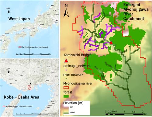
Abstract
The authors present an attempt to reproduce a flash flood in the steep mountainous Myohoujigawa River, Japan, using a physics-based distributed rainfall-runoff/flood-inundation model (DRRFI). The Myohoujigawa River is located in Kobe city. The length is 6.975 km and the area is 11.81 km2. The authors aimed to simulate a 4 m rise in the water level within 40 min in the catchment. Man-made open-channel rainwater drainages were added to the river network which could collect more rainwater faster. Likewise, the flux difference splitting (FDS) scheme was used for 1D dynamic wave modeling of steep river flow because it can simulate sub- and super-critical flow regimes. Moreover, the X-band rainfall data of 250 m and 1 min spatiotemporal resolution, currently the highest-resolution product in Japan, served as input for the rainfall-runoff-inundation model. Consequently, a level of reproducibility was achieved via runoff simulation using the X-band rainfall data. Subsequently, 21 forecast ensemble rainfalls under the operation of the Japan Meteorological Agency were used for the feasibility study of ensemble flood forecasting. This ensemble flood simulation aimed to determine that the 5 km and 1 h spatiotemporal resolution of the ensemble rainfall currently best product available to the general public in Japan were sufficient to reproduce the flash flood that occurred within 40 min. The 21 ensemble flood simulations exhibited qualitatively acceptable results as the water level rise timings are similar; however, quantitatively the simulated water levels were lower than those of the observed water.
期刊介绍:
Journal of Flood Risk Management provides an international platform for knowledge sharing in all areas related to flood risk. Its explicit aim is to disseminate ideas across the range of disciplines where flood related research is carried out and it provides content ranging from leading edge academic papers to applied content with the practitioner in mind.
Readers and authors come from a wide background and include hydrologists, meteorologists, geographers, geomorphologists, conservationists, civil engineers, social scientists, policy makers, insurers and practitioners. They share an interest in managing the complex interactions between the many skills and disciplines that underpin the management of flood risk across the world.

 求助内容:
求助内容: 应助结果提醒方式:


