Quantifying contamination risks: Groundwater vulnerability assessment at an MSW dumpsite with advanced profiling tools
IF 7.3
2区 环境科学与生态学
Q1 ENVIRONMENTAL SCIENCES
引用次数: 0
Abstract
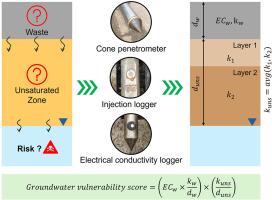
Traditional groundwater vulnerability assessment methods rely on regional-scale parameters that often overlook local soil variation. They also tend to ignore the contamination potential at already contaminated sites, particularly in heterogeneous environments. This study employs advanced direct push profiling tools to quantify groundwater vulnerability at an MSW dumpsite using real-time hydrogeological and contamination data. A vulnerability score was developed considering waste, unsaturated and saturated zone permeability, water table depth, and the waste bulk electrical conductivity. All parameters were calculated from the cone penetrometer (CPT), direct push injection logger (DPIL) and electrical conductivity (EC) logger profiles. A laboratory and computational validation of DPIL and EC was carried out before the field tests and their capabilities and limitations were discussed in detail. It was concluded that the permeability of MSW was better estimated by the DPIL than CPT due to the presence of construction and demolition waste (C&DW) influencing the CPT values. Conversely, CPT provided more realistic values in the low permeability soils i.e., soils with permeability less than 10−6 m/s, which are beyond the measurable range of DPIL. The bulk EC was a reliable proxy for leachate contamination potential in most cases except in soils with very low water content. The groundwater vulnerability score (GWVS) was calculated for different regions in the landfill with varying subsurface and waste conditions. The boundary region of the landfill had a higher GWVS than the interior region due to the presence of high permeability unsaturated zone, indicating the need for remediation of the entire site. The proposed framework can assist in prioritizing remediation efforts on high-risk zones identified in this study.

量化污染风险:使用先进分析工具对城市生活垃圾倾倒场的地下水脆弱性进行评估
传统的地下水脆弱性评价方法依赖于区域尺度的参数,往往忽略了局部土壤的变化。他们还倾向于忽视已经被污染的地点的污染潜力,特别是在异质环境中。本研究采用先进的直推分析工具,利用实时水文地质和污染数据,量化城市生活垃圾垃圾场的地下水脆弱性。考虑垃圾、非饱和带和饱和带渗透率、地下水位深度和垃圾总体电导率,建立了脆弱性评分。所有参数均通过锥贯仪(CPT)、直推式注入记录仪(dpl)和电导率记录仪(EC)剖面进行计算。在现场试验之前,对DPIL和EC进行了实验室验证和计算验证,并详细讨论了它们的能力和局限性。结果表明,由于建筑和拆除垃圾(C&;DW)的存在对CPT值的影响,DPIL比CPT能更好地估计城市生活垃圾的渗透率。相反,CPT在渗透性小于10-6 m/s的低渗透土壤中提供了更真实的值,超出了DPIL的测量范围。除含水量非常低的土壤外,大部分情况下,散装EC是渗滤液污染潜力的可靠代表。计算了不同地下和废弃物条件下填埋场不同区域地下水脆弱性评分(GWVS)。填埋场边界区域由于存在高渗透非饱和带,GWVS高于内部区域,表明需要对整个场地进行修复。建议的框架可以帮助确定本研究中确定的高风险区域的修复工作的优先次序。
本文章由计算机程序翻译,如有差异,请以英文原文为准。
求助全文
约1分钟内获得全文
求助全文
来源期刊
Environmental Pollution
环境科学-环境科学
CiteScore
16.00
自引率
6.70%
发文量
2082
审稿时长
2.9 months
期刊介绍:
Environmental Pollution is an international peer-reviewed journal that publishes high-quality research papers and review articles covering all aspects of environmental pollution and its impacts on ecosystems and human health.
Subject areas include, but are not limited to:
• Sources and occurrences of pollutants that are clearly defined and measured in environmental compartments, food and food-related items, and human bodies;
• Interlinks between contaminant exposure and biological, ecological, and human health effects, including those of climate change;
• Contaminants of emerging concerns (including but not limited to antibiotic resistant microorganisms or genes, microplastics/nanoplastics, electronic wastes, light, and noise) and/or their biological, ecological, or human health effects;
• Laboratory and field studies on the remediation/mitigation of environmental pollution via new techniques and with clear links to biological, ecological, or human health effects;
• Modeling of pollution processes, patterns, or trends that is of clear environmental and/or human health interest;
• New techniques that measure and examine environmental occurrences, transport, behavior, and effects of pollutants within the environment or the laboratory, provided that they can be clearly used to address problems within regional or global environmental compartments.
 求助内容:
求助内容: 应助结果提醒方式:


