Interplay of climate change and human activities on the hydrological dynamics and environmental degradation of the Senguerr River Basin, Argentina
IF 1.5
4区 地球科学
Q3 GEOSCIENCES, MULTIDISCIPLINARY
引用次数: 0
Abstract
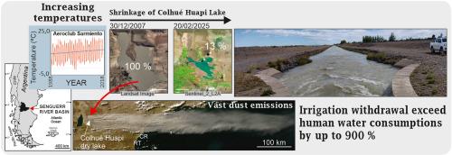
This study examines the multi-annual evolution of the Senguerr River Basin in central Patagonia (Argentina), focusing on fluvial dynamics and long-term hydrological changes. The analysis of climatic and hydrological data since 1950 identified eight distinct hydrological stages, with runoff trends strongly correlated to ENSO phases. During the La Niña phases, discharge in downstream areas decreases by 33–36 % compared to the El Niño phases. Gradual increases in average temperatures and decreased winter precipitations lead to pronounced water deficits in summer, with changes in the snow-to-rain ratio. Hydrograph analysis in the basin's headwaters reveals three major periods: (i) 1950–1976, characterized by two flood peaks—one from winter precipitation, another from spring snowmelt; (ii) 1978–2000, marked by reduced discharge and smoother hydrographs; and (iii) 2001–2024, showing erratic precipitation and sharp-peaked hydrographs, indicative of a rain-dominated catchment. In recent decades and due to climate warming, the Lower Basin faces a seasonal hydrological deficit, with an annual precipitation of 154 mm and evaporation of 1738 mm. However, despite a 2.18 °C temperature increase (1989–2015), reduced summer wind velocity, likely due to a southward shift of the westerlies, has mitigated evaporation rates. Agricultural water use in the Upper Basin and Sarmiento Delta surpasses urban consumption by over 900 %, with irrigation in the Upper Basin using three times the combined domestic and industrial water supply and 6.23 times more in the Lower Basin. The desiccation of Colhué Huapi Lake is driven by reduced discharge through the Falso Senguerr course and increasing La Niña frequency, exacerbated by higher water consumption in the Lower Basin. These processes have intensified desertification, favoring the formation and migration of eolian dunes on the dry substrate and increasing dust transport during windstorms.
气候变化和人类活动对阿根廷森格尔河流域水文动态和环境退化的相互作用
本研究考察了巴塔哥尼亚中部(阿根廷)sengerr河流域的多年演变,重点关注河流动力学和长期水文变化。对1950年以来的气候和水文数据的分析确定了8个不同的水文阶段,径流趋势与ENSO阶段密切相关。在La Niña阶段,下游地区的流量比El Niño阶段减少了33 - 36%。平均气温的逐渐升高和冬季降水的减少导致夏季明显的水分亏缺,雪雨比发生变化。流域源头的水文曲线分析揭示了三个主要时期:(i) 1950-1976年,以两次洪峰为特征,一次来自冬季降水,另一次来自春季融雪;(ii) 1978-2000年,其特点是流量减少,水线平滑;(iii) 2001-2024年,降水不稳定,水文曲线尖峰,表明流域以雨为主。近几十年来,由于气候变暖,下游流域面临季节性水文亏缺,年降水量为154 mm,蒸发量为1738 mm。然而,尽管(1989-2015年)气温上升了2.18°C,夏季风速的降低(可能是由于西风带向南移动)减缓了蒸发速率。上游流域和萨米恩托三角洲的农业用水量超过城市用水量900%以上,上游流域的灌溉用水量是生活和工业用水总和的三倍,下游流域是6.23倍。花皮湖的干旱化是由Falso sengerr河道的流量减少和La Niña频率的增加驱动的,下游流域的高耗水量加剧了这种干旱化。这些过程加剧了沙漠化,有利于干燥基底上风成沙丘的形成和迁移,增加了沙尘暴期间的沙尘输送。
本文章由计算机程序翻译,如有差异,请以英文原文为准。
求助全文
约1分钟内获得全文
求助全文
来源期刊

Journal of South American Earth Sciences
地学-地球科学综合
CiteScore
3.70
自引率
22.20%
发文量
364
审稿时长
6-12 weeks
期刊介绍:
Papers must have a regional appeal and should present work of more than local significance. Research papers dealing with the regional geology of South American cratons and mobile belts, within the following research fields:
-Economic geology, metallogenesis and hydrocarbon genesis and reservoirs.
-Geophysics, geochemistry, volcanology, igneous and metamorphic petrology.
-Tectonics, neo- and seismotectonics and geodynamic modeling.
-Geomorphology, geological hazards, environmental geology, climate change in America and Antarctica, and soil research.
-Stratigraphy, sedimentology, structure and basin evolution.
-Paleontology, paleoecology, paleoclimatology and Quaternary geology.
New developments in already established regional projects and new initiatives dealing with the geology of the continent will be summarized and presented on a regular basis. Short notes, discussions, book reviews and conference and workshop reports will also be included when relevant.
 求助内容:
求助内容: 应助结果提醒方式:


