Marcel Iten, Shuyin Mao, Yuanxin Pan, Benedikt Soja
{"title":"Enhanced real-time global ionospheric maps using machine learning.","authors":"Marcel Iten, Shuyin Mao, Yuanxin Pan, Benedikt Soja","doi":"10.1007/s10291-025-01858-0","DOIUrl":null,"url":null,"abstract":"<p><p>Global ionospheric maps (GIM) are commonly used ionospheric products in high-precision Global Navigation Satellite System (GNSS) applications. To meet the increasing demand for real-time (RT) applications, the International GNSS Service (IGS) officially started a real-time service in 2013. One of the tasks of the real-time service is the calculation of real-time GIMs. However, the accuracy of current real-time GIMs is still significantly worse than that of the final GIMs, which are the most accurate ionospheric products but have a latency of several days. The IGS RT GIMs exhibit an RMSE of around 3.5-5.5 total electron content units (TECU) compared to the final GIMs. This study focuses on improving the accuracy of existing real-time GIMs through machine learning (ML) approaches, specifically convolutional neural networks (CNN) and conditional generative adversarial networks (cGAN). We apply our method to the IGS combined real-time GIMs and to Universitat Politècnica de Catalunya (UPC) GIMs. We consider over 130'000 pairs of real-time and final GIMs. Over a 3.5-month test period, the proposed approach shows promising results with a reduction of more than 30% in mean absolute error for the real-time GIMs. Especially for regions with high VTEC values, we find a significant improvement of nearly 50%. The ML-enhanced real-time GIMs also exhibit improved positioning performance for single-frequency GNSS positioning with reductions in the 3D error up to 21 cm. Overall, our proposed method demonstrates great potential in generating more accurate and refined real-time GIMs.</p>","PeriodicalId":12788,"journal":{"name":"GPS Solutions","volume":"29 3","pages":"108"},"PeriodicalIF":3.9000,"publicationDate":"2025-01-01","publicationTypes":"Journal Article","fieldsOfStudy":null,"isOpenAccess":false,"openAccessPdf":"https://www.ncbi.nlm.nih.gov/pmc/articles/PMC12069473/pdf/","citationCount":"0","resultStr":null,"platform":"Semanticscholar","paperid":null,"PeriodicalName":"GPS Solutions","FirstCategoryId":"5","ListUrlMain":"https://doi.org/10.1007/s10291-025-01858-0","RegionNum":1,"RegionCategory":"地球科学","ArticlePicture":[],"TitleCN":null,"AbstractTextCN":null,"PMCID":null,"EPubDate":"2025/5/12 0:00:00","PubModel":"Epub","JCR":"Q1","JCRName":"REMOTE SENSING","Score":null,"Total":0}
引用次数: 0
Abstract
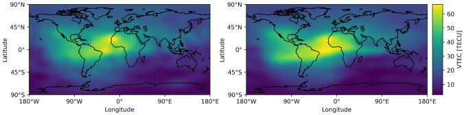
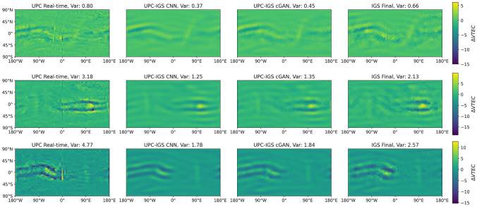
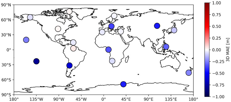
Global ionospheric maps (GIM) are commonly used ionospheric products in high-precision Global Navigation Satellite System (GNSS) applications. To meet the increasing demand for real-time (RT) applications, the International GNSS Service (IGS) officially started a real-time service in 2013. One of the tasks of the real-time service is the calculation of real-time GIMs. However, the accuracy of current real-time GIMs is still significantly worse than that of the final GIMs, which are the most accurate ionospheric products but have a latency of several days. The IGS RT GIMs exhibit an RMSE of around 3.5-5.5 total electron content units (TECU) compared to the final GIMs. This study focuses on improving the accuracy of existing real-time GIMs through machine learning (ML) approaches, specifically convolutional neural networks (CNN) and conditional generative adversarial networks (cGAN). We apply our method to the IGS combined real-time GIMs and to Universitat Politècnica de Catalunya (UPC) GIMs. We consider over 130'000 pairs of real-time and final GIMs. Over a 3.5-month test period, the proposed approach shows promising results with a reduction of more than 30% in mean absolute error for the real-time GIMs. Especially for regions with high VTEC values, we find a significant improvement of nearly 50%. The ML-enhanced real-time GIMs also exhibit improved positioning performance for single-frequency GNSS positioning with reductions in the 3D error up to 21 cm. Overall, our proposed method demonstrates great potential in generating more accurate and refined real-time GIMs.
期刊介绍:
GPS Solutions is a scientific journal. It is published quarterly and features system design issues and a full range of current and emerging applications of global navigation satellite systems (GNSS) such as GPS, GLONASS, Galileo, BeiDou, local systems, and augmentations. Novel, innovative, or highly demanding uses are of prime interest. Areas of application include: aviation, surveying and mapping, forestry and agriculture, maritime and waterway navigation, public transportation, time and frequency comparisons and dissemination, space and satellite operations, law enforcement and public safety, communications, meteorology and atmospheric science, geosciences, monitoring global change, technology and engineering, GIS, geodesy, and others.
GPS Solutions addresses the latest developments in GNSS infrastructure, mathematical modeling, algorithmic developments and data analysis, user hardware, and general issues that impact the user community. Contributions from the entire spectrum of GNSS professionals are represented, including university researchers, scientists from government laboratories, receiver industry and other commercial developers, public officials, and business leaders.
 求助内容:
求助内容: 应助结果提醒方式:


