SPATIAL and temporal dynamics of groundwater vulnerability to contaminants under climate and land use changes in the Pra and Ankobra basins
引用次数: 0
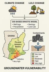
Abstract
Groundwater resources in Ghana’s Pra and Ankobra Basins face growing contamination risks due to the combined effects of climate change and land use/land cover (LULC) modifications, with existing studies often examining these drivers in isolation. This investigation addresses this gap by examining how groundwater recharge variability, influenced by these environmental changes, affects aquifer vulnerability to contaminants. An integrated GIS-based DRASTIC model approach incorporating well logs, precipitation records, geological maps, and land use data assessed and mapped climate-LULC interactions on vulnerability zones across the basins. Results demonstrate significant spatiotemporal variability, with 32 % of the area classified as moderately vulnerable, while high (23 %) and very high (17 %) vulnerability zones concentrate predominantly in the Ankobra Basin, particularly near mining towns like Prestea, Tarkwa, and Bibiani. Model validation confirmed high reliability (85 % accuracy, Kappa = 0.65), with projections indicating a transition toward lower vulnerability under future scenarios. Very low vulnerability areas may expand across all periods (near, mid, and far future), while high and very high zones could decline by 9.58 % and 11.93 % respectively by the far future. The findings highlight the need for targeted strategies in mining-affected areas, including stricter environmental regulations, groundwater protection zones, and sustainable land management. Integrating continuous monitoring with adaptive approaches, such as artificial recharge systems and climate-informed land use planning, can enhance groundwater resilience. This study provides policymakers and water managers with actionable insights to develop robust protection measures, offering a transferable framework for vulnerable basins facing similar climatic and anthropogenic stresses. Science-based monitoring and multi-stakeholder collaboration emerge as critical components for safeguarding groundwater resources under changing environmental conditions.
普拉和安科布拉流域气候和土地利用变化下地下水对污染物脆弱性的时空动态
由于气候变化和土地利用/土地覆盖(LULC)变化的综合影响,加纳Pra和Ankobra盆地的地下水资源面临越来越大的污染风险,而现有的研究往往是孤立地考察这些驱动因素。本研究通过研究受这些环境变化影响的地下水补给可变性如何影响含水层对污染物的脆弱性,解决了这一空白。基于gis的DRASTIC模型综合了测井、降水记录、地质图和土地利用数据,评估并绘制了整个盆地脆弱地带的气候- lulc相互作用。结果显示出显著的时空变异性,32%的区域被划分为中度脆弱区,而高(23%)和高(17%)脆弱区主要集中在Ankobra盆地,特别是在Prestea, Tarkwa和Bibiani等矿业城镇附近。模型验证证实了高可靠性(85%的准确率,Kappa = 0.65),预测表明在未来情景下向更低的脆弱性过渡。在近、中、远期各时期,极低脆弱性区均可能扩大,而高脆弱性区和极高脆弱性区在远期分别下降9.58%和11.93%。研究结果强调,在受采矿影响的地区需要有针对性的战略,包括更严格的环境法规、地下水保护区和可持续的土地管理。将持续监测与适应性方法(如人工补给系统和气候知情土地利用规划)相结合,可以增强地下水的复原力。这项研究为政策制定者和水资源管理者提供了可行的见解,以制定强有力的保护措施,为面临类似气候和人为压力的脆弱流域提供了一个可转移的框架。基于科学的监测和多方利益相关者合作成为在不断变化的环境条件下保护地下水资源的关键组成部分。
本文章由计算机程序翻译,如有差异,请以英文原文为准。
求助全文
约1分钟内获得全文
求助全文

 求助内容:
求助内容: 应助结果提醒方式:


