A. A. Nevzorov, A. V. Nevzorov, N. S. Kravtsova, O. V. Kharchenko, Ya. O. Romanovskii
{"title":"Comparison of MetOp Satellite and Mobile Lidar Ozone Profiles","authors":"A. A. Nevzorov, A. V. Nevzorov, N. S. Kravtsova, O. V. Kharchenko, Ya. O. Romanovskii","doi":"10.1134/S1024856024701379","DOIUrl":null,"url":null,"abstract":"<p>Atmospheric trace gases (ATGs) are optically active constituents of the atmosphere. ATGs have a great influence on atmospheric processes: transformation of solar radiation, weather formation, air pollution by industrial emissions, and propagation of optical waves. Ozone occupies a special place among ATGs. The ozone layer plays the role of natural protection of the planet from shortwave solar radiation. Therefore, monitoring of the ozonosphere by ground-based and satellite instruments allows us to obtain the most reliable data on the state of the atmosphere and, in particular, the ozone layer. The solution of this urgent problem is possible only with permanent improvement of the hardware base and perfection of methodological approaches to scientific research of the atmosphere. In this work, a number of measurements were carried out using a mobile ozone lidar at the sensing wavelengths of 299/341 nm in the altitude range 0.1–12 km at the Siberian lidar station (SLS). Vertical ozone profiles retrieved from lidar and meteorological satellite data of the European Space Agency (MetOp) obtained in 2023 were compared. The comparisons showed that the average relative difference between the profiles varies from −65.6% to 15.3% at altitudes from 0.1 km to 12 km. The comparison results confirm good prospects for using these ozone sensing wavelengths in the altitude range 0.1–5 km, previously uncovered by the SLS. The results will be used in modeling the vertical distribution of ozone concentration and in assessing the ecological state of the atmosphere in the Tomsk oblast.</p>","PeriodicalId":46751,"journal":{"name":"Atmospheric and Oceanic Optics","volume":"38 1","pages":"112 - 117"},"PeriodicalIF":0.9000,"publicationDate":"2025-04-29","publicationTypes":"Journal Article","fieldsOfStudy":null,"isOpenAccess":false,"openAccessPdf":"","citationCount":"0","resultStr":null,"platform":"Semanticscholar","paperid":null,"PeriodicalName":"Atmospheric and Oceanic Optics","FirstCategoryId":"1085","ListUrlMain":"https://link.springer.com/article/10.1134/S1024856024701379","RegionNum":0,"RegionCategory":null,"ArticlePicture":[],"TitleCN":null,"AbstractTextCN":null,"PMCID":null,"EPubDate":"","PubModel":"","JCR":"Q4","JCRName":"OPTICS","Score":null,"Total":0}
引用次数: 0
Abstract
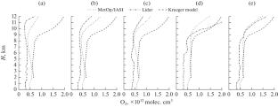
Atmospheric trace gases (ATGs) are optically active constituents of the atmosphere. ATGs have a great influence on atmospheric processes: transformation of solar radiation, weather formation, air pollution by industrial emissions, and propagation of optical waves. Ozone occupies a special place among ATGs. The ozone layer plays the role of natural protection of the planet from shortwave solar radiation. Therefore, monitoring of the ozonosphere by ground-based and satellite instruments allows us to obtain the most reliable data on the state of the atmosphere and, in particular, the ozone layer. The solution of this urgent problem is possible only with permanent improvement of the hardware base and perfection of methodological approaches to scientific research of the atmosphere. In this work, a number of measurements were carried out using a mobile ozone lidar at the sensing wavelengths of 299/341 nm in the altitude range 0.1–12 km at the Siberian lidar station (SLS). Vertical ozone profiles retrieved from lidar and meteorological satellite data of the European Space Agency (MetOp) obtained in 2023 were compared. The comparisons showed that the average relative difference between the profiles varies from −65.6% to 15.3% at altitudes from 0.1 km to 12 km. The comparison results confirm good prospects for using these ozone sensing wavelengths in the altitude range 0.1–5 km, previously uncovered by the SLS. The results will be used in modeling the vertical distribution of ozone concentration and in assessing the ecological state of the atmosphere in the Tomsk oblast.
期刊介绍:
Atmospheric and Oceanic Optics is an international peer reviewed journal that presents experimental and theoretical articles relevant to a wide range of problems of atmospheric and oceanic optics, ecology, and climate. The journal coverage includes: scattering and transfer of optical waves, spectroscopy of atmospheric gases, turbulent and nonlinear optical phenomena, adaptive optics, remote (ground-based, airborne, and spaceborne) sensing of the atmosphere and the surface, methods for solving of inverse problems, new equipment for optical investigations, development of computer programs and databases for optical studies. Thematic issues are devoted to the studies of atmospheric ozone, adaptive, nonlinear, and coherent optics, regional climate and environmental monitoring, and other subjects.
 求助内容:
求助内容: 应助结果提醒方式:


