{"title":"Integrating Airborne Geophysics Data for Geological Mapping and Porphyry Mineralization Prospectivity in the Shahr-e-Babak Area, Southeastern Iran","authors":"Moslem Jahantigh, Hamidreza Ramazi","doi":"10.1007/s00024-024-03627-5","DOIUrl":null,"url":null,"abstract":"<div><p>This paper is devoted to application of airborne geophysical data consisting of aeromagnetic and radiometric data to interpret the geology, lineament structures, high magnetic anomalies, and high favorability areas of porphyry mineralization in the Shahr-e-Babak study area. The maps of reduction to magnetic pole, potassium, thorium, uranium, ternary map of potassium, thorium, and uranium radioelements were used for geological interpretation in the study area. The ratio of K/Th, tilt angle, fractal and fuzzy logic methods were also applied to interpret geophysical data. To identify alteration zones in the area, arithmetic ratio of the K/Th map was used. The fractal method was used to delineate high magnetic anomalies and highly altered zones. The high magnetic anomalies could be coincident with heat sources of porphyry deposits. To identify linear structures tilt derivative method was applied. These linear structures are appropriate for hydrothermal fluid circulation and porphyry mineralization in the area. Some constrain magnetic anomalies were identified based on geological interpretation of aeromagnetic data. Cu indices were consistent with high magnetic anomalies. Based on geological interpretation of airborne radiometric data, volcanic and subvolcanic rocks reflect high radiometric anomalies while sedimentary rocks reflect low radiometric anomalies. Altered areas were extracted using airborne radiometric data and the fractal method. Lineaments were extracted from the tilt derivative map and this map was utilized for compiling density map of linear structures. The Cu indices showed an appropriate overlay with the line density map. In the final stage, three evidential layers including linear structures, high magnetic anomalies, and alteration zone resulting from the K/Th anomaly map were integrated to delineate high potential areas, by applying the fuzzy logic method.</p></div>","PeriodicalId":21078,"journal":{"name":"pure and applied geophysics","volume":"182 4","pages":"1637 - 1656"},"PeriodicalIF":1.9000,"publicationDate":"2025-02-11","publicationTypes":"Journal Article","fieldsOfStudy":null,"isOpenAccess":false,"openAccessPdf":"","citationCount":"0","resultStr":null,"platform":"Semanticscholar","paperid":null,"PeriodicalName":"pure and applied geophysics","FirstCategoryId":"89","ListUrlMain":"https://link.springer.com/article/10.1007/s00024-024-03627-5","RegionNum":4,"RegionCategory":"地球科学","ArticlePicture":[],"TitleCN":null,"AbstractTextCN":null,"PMCID":null,"EPubDate":"","PubModel":"","JCR":"Q2","JCRName":"GEOCHEMISTRY & GEOPHYSICS","Score":null,"Total":0}
引用次数: 0
Abstract
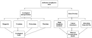
This paper is devoted to application of airborne geophysical data consisting of aeromagnetic and radiometric data to interpret the geology, lineament structures, high magnetic anomalies, and high favorability areas of porphyry mineralization in the Shahr-e-Babak study area. The maps of reduction to magnetic pole, potassium, thorium, uranium, ternary map of potassium, thorium, and uranium radioelements were used for geological interpretation in the study area. The ratio of K/Th, tilt angle, fractal and fuzzy logic methods were also applied to interpret geophysical data. To identify alteration zones in the area, arithmetic ratio of the K/Th map was used. The fractal method was used to delineate high magnetic anomalies and highly altered zones. The high magnetic anomalies could be coincident with heat sources of porphyry deposits. To identify linear structures tilt derivative method was applied. These linear structures are appropriate for hydrothermal fluid circulation and porphyry mineralization in the area. Some constrain magnetic anomalies were identified based on geological interpretation of aeromagnetic data. Cu indices were consistent with high magnetic anomalies. Based on geological interpretation of airborne radiometric data, volcanic and subvolcanic rocks reflect high radiometric anomalies while sedimentary rocks reflect low radiometric anomalies. Altered areas were extracted using airborne radiometric data and the fractal method. Lineaments were extracted from the tilt derivative map and this map was utilized for compiling density map of linear structures. The Cu indices showed an appropriate overlay with the line density map. In the final stage, three evidential layers including linear structures, high magnetic anomalies, and alteration zone resulting from the K/Th anomaly map were integrated to delineate high potential areas, by applying the fuzzy logic method.
期刊介绍:
pure and applied geophysics (pageoph), a continuation of the journal "Geofisica pura e applicata", publishes original scientific contributions in the fields of solid Earth, atmospheric and oceanic sciences. Regular and special issues feature thought-provoking reports on active areas of current research and state-of-the-art surveys.
Long running journal, founded in 1939 as Geofisica pura e applicata
Publishes peer-reviewed original scientific contributions and state-of-the-art surveys in solid earth and atmospheric sciences
Features thought-provoking reports on active areas of current research and is a major source for publications on tsunami research
Coverage extends to research topics in oceanic sciences
See Instructions for Authors on the right hand side.
 求助内容:
求助内容: 应助结果提醒方式:


