Geo-hydrological analysis and watershed delineation of the Sarayan River, Ganga Plain, India: integrating geospatial data for water resource management
{"title":"Geo-hydrological analysis and watershed delineation of the Sarayan River, Ganga Plain, India: integrating geospatial data for water resource management","authors":"Pawan Kumar Gautam, Narendra Kumar","doi":"10.1007/s12517-025-12255-9","DOIUrl":null,"url":null,"abstract":"<div><p>This study focuses on the drainage parameters and basin characteristics of the Sarayan basin using geospatial techniques. The Sarayan basin is situated in the interfluve region of the Gomati and Ghaghara River within the Middle Ganga Plain. It is the left tributary of the Gomati River that flows within the Ganga Plain of Uttar Pradesh, India. Various parameters, including linear, areal, relief, geometric, and morpho-tectonic, were calculated to assess the basin’s shape, drainage pattern, and topographical characteristics. It is classified as a fifth-order stream. It exhibits a dendritic type of drainage pattern that covers an area of 1695 km<sup>2</sup>. The analysis reveals the basin characteristics by a mature alluvial river system, dendritic drainage pattern, indicating homogeneity in texture and underlying geology and stable geomorphic conditions. Linear parameters indicate a gentle ground slope and minimal soil erosion within the basin. Areal parameters further emphasize smooth topography, low runoff potential, gentle slope, lower susceptibility to soil erosion, efficient infiltration, and enhanced permeability, resulting in prolonged flow paths that facilitate effective groundwater recharge processes. Morphtectonic parameters, including the sinuosity index (1.60), reveal diverse levels of channel sinuosity within the basin. Values ranging from 1.07 to 1.27 signify low sinuosity, while those between 1.31 and 1.44 suggest heightened sinuosity and lateral erosion. A SI of 1.50 and 1.82 indicates various degrees of river meandering and lateral erosion. Additionally, the asymmetry factor (59) indicates channel migration towards the east. The hypsometric integrals (0.50) suggest a mature landscape characterized by a low stage of incision and minimal sediment transport. In summary, the study presents a comprehensive analysis of the Sarayan River drainage and basin characteristics, shedding light on its hydrological dynamics and geomorphic evolution within the Ganga Plain.\n</p></div>","PeriodicalId":476,"journal":{"name":"Arabian Journal of Geosciences","volume":"18 5","pages":""},"PeriodicalIF":1.8270,"publicationDate":"2025-04-15","publicationTypes":"Journal Article","fieldsOfStudy":null,"isOpenAccess":false,"openAccessPdf":"","citationCount":"0","resultStr":null,"platform":"Semanticscholar","paperid":null,"PeriodicalName":"Arabian Journal of Geosciences","FirstCategoryId":"1085","ListUrlMain":"https://link.springer.com/article/10.1007/s12517-025-12255-9","RegionNum":0,"RegionCategory":null,"ArticlePicture":[],"TitleCN":null,"AbstractTextCN":null,"PMCID":null,"EPubDate":"","PubModel":"","JCR":"Q2","JCRName":"Earth and Planetary Sciences","Score":null,"Total":0}
引用次数: 0
Abstract
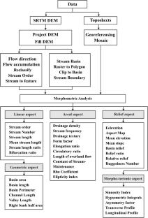
This study focuses on the drainage parameters and basin characteristics of the Sarayan basin using geospatial techniques. The Sarayan basin is situated in the interfluve region of the Gomati and Ghaghara River within the Middle Ganga Plain. It is the left tributary of the Gomati River that flows within the Ganga Plain of Uttar Pradesh, India. Various parameters, including linear, areal, relief, geometric, and morpho-tectonic, were calculated to assess the basin’s shape, drainage pattern, and topographical characteristics. It is classified as a fifth-order stream. It exhibits a dendritic type of drainage pattern that covers an area of 1695 km2. The analysis reveals the basin characteristics by a mature alluvial river system, dendritic drainage pattern, indicating homogeneity in texture and underlying geology and stable geomorphic conditions. Linear parameters indicate a gentle ground slope and minimal soil erosion within the basin. Areal parameters further emphasize smooth topography, low runoff potential, gentle slope, lower susceptibility to soil erosion, efficient infiltration, and enhanced permeability, resulting in prolonged flow paths that facilitate effective groundwater recharge processes. Morphtectonic parameters, including the sinuosity index (1.60), reveal diverse levels of channel sinuosity within the basin. Values ranging from 1.07 to 1.27 signify low sinuosity, while those between 1.31 and 1.44 suggest heightened sinuosity and lateral erosion. A SI of 1.50 and 1.82 indicates various degrees of river meandering and lateral erosion. Additionally, the asymmetry factor (59) indicates channel migration towards the east. The hypsometric integrals (0.50) suggest a mature landscape characterized by a low stage of incision and minimal sediment transport. In summary, the study presents a comprehensive analysis of the Sarayan River drainage and basin characteristics, shedding light on its hydrological dynamics and geomorphic evolution within the Ganga Plain.
期刊介绍:
The Arabian Journal of Geosciences is the official journal of the Saudi Society for Geosciences and publishes peer-reviewed original and review articles on the entire range of Earth Science themes, focused on, but not limited to, those that have regional significance to the Middle East and the Euro-Mediterranean Zone.
Key topics therefore include; geology, hydrogeology, earth system science, petroleum sciences, geophysics, seismology and crustal structures, tectonics, sedimentology, palaeontology, metamorphic and igneous petrology, natural hazards, environmental sciences and sustainable development, geoarchaeology, geomorphology, paleo-environment studies, oceanography, atmospheric sciences, GIS and remote sensing, geodesy, mineralogy, volcanology, geochemistry and metallogenesis.

 求助内容:
求助内容: 应助结果提醒方式:


