Catherine E. Lovelock, Marilyn C. Ball, Nigel Brothers, Alex Pearse, Ruth Reef
{"title":"Dynamics of surface accretion and surface elevation differ between river and tide dominated settings in tropical mangroves","authors":"Catherine E. Lovelock, Marilyn C. Ball, Nigel Brothers, Alex Pearse, Ruth Reef","doi":"10.1002/lno.70024","DOIUrl":null,"url":null,"abstract":"<p>The maintenance of soil surface elevation in mangroves supports the persistence of mangroves with sea level rise. The processes contributing to soil surface elevation have rarely been assessed in the humid tropics, despite most mangroves occurring in river deltas and tidal estuaries within this climate zone. Using surface elevation table (SET) with marker horizon methods over sites that occurred on either the main river channel or a tidal channel, we assessed the role of rainfall and associated river discharge in moderating surface elevation in mangroves of the Daintree River, Queensland, Australia. In the sites in the main river channel close to the river mouth, increases in soil surface elevation were episodic, with river flooding leading to greater accretion of sediment and increases in surface elevation in years with high river discharge, while in the tidal channel further from the mouth, sediment accretion and surface elevation increments were variable among years and not linked to river discharge. Our study finds that the 32.7 km<sup>2</sup> of mangroves of the Daintree River estuary have surface elevation gains that are variable but similar to current rates of sea level rise through trapping of around 40,000 t of sediment annually, mainly within the downstream mangroves and those in the main river channel. Extreme rainfall and river flows have spatially variable influences on surface elevation in mangroves of the Daintree River, which may lead to similarly variable responses to accelerating sea level rise.</p>","PeriodicalId":18143,"journal":{"name":"Limnology and Oceanography","volume":"70 5","pages":"1424-1437"},"PeriodicalIF":3.7000,"publicationDate":"2025-03-26","publicationTypes":"Journal Article","fieldsOfStudy":null,"isOpenAccess":false,"openAccessPdf":"https://onlinelibrary.wiley.com/doi/epdf/10.1002/lno.70024","citationCount":"0","resultStr":null,"platform":"Semanticscholar","paperid":null,"PeriodicalName":"Limnology and Oceanography","FirstCategoryId":"89","ListUrlMain":"https://onlinelibrary.wiley.com/doi/10.1002/lno.70024","RegionNum":1,"RegionCategory":"地球科学","ArticlePicture":[],"TitleCN":null,"AbstractTextCN":null,"PMCID":null,"EPubDate":"","PubModel":"","JCR":"Q1","JCRName":"LIMNOLOGY","Score":null,"Total":0}
引用次数: 0
Abstract
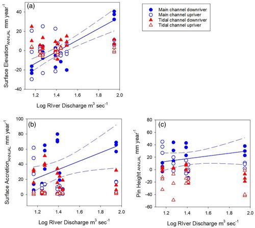
The maintenance of soil surface elevation in mangroves supports the persistence of mangroves with sea level rise. The processes contributing to soil surface elevation have rarely been assessed in the humid tropics, despite most mangroves occurring in river deltas and tidal estuaries within this climate zone. Using surface elevation table (SET) with marker horizon methods over sites that occurred on either the main river channel or a tidal channel, we assessed the role of rainfall and associated river discharge in moderating surface elevation in mangroves of the Daintree River, Queensland, Australia. In the sites in the main river channel close to the river mouth, increases in soil surface elevation were episodic, with river flooding leading to greater accretion of sediment and increases in surface elevation in years with high river discharge, while in the tidal channel further from the mouth, sediment accretion and surface elevation increments were variable among years and not linked to river discharge. Our study finds that the 32.7 km2 of mangroves of the Daintree River estuary have surface elevation gains that are variable but similar to current rates of sea level rise through trapping of around 40,000 t of sediment annually, mainly within the downstream mangroves and those in the main river channel. Extreme rainfall and river flows have spatially variable influences on surface elevation in mangroves of the Daintree River, which may lead to similarly variable responses to accelerating sea level rise.
期刊介绍:
Limnology and Oceanography (L&O; print ISSN 0024-3590, online ISSN 1939-5590) publishes original articles, including scholarly reviews, about all aspects of limnology and oceanography. The journal''s unifying theme is the understanding of aquatic systems. Submissions are judged on the originality of their data, interpretations, and ideas, and on the degree to which they can be generalized beyond the particular aquatic system examined. Laboratory and modeling studies must demonstrate relevance to field environments; typically this means that they are bolstered by substantial "real-world" data. Few purely theoretical or purely empirical papers are accepted for review.
 求助内容:
求助内容: 应助结果提醒方式:


