Hyperspectral remote sensing for air pollutants: Stereoscopic monitoring, source localization & warning, and a dynamic emission inventory concept
IF 9.7
1区 环境科学与生态学
Q1 ENVIRONMENTAL SCIENCES
引用次数: 0
Abstract
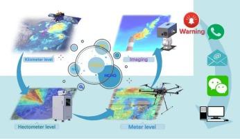
With the continuous improvement of air quality in China, the characteristics of emission sources of pollutants have changed significantly, from their distribution to emitted atmospheric species and the corresponding emission concentrations and source localization has become increasingly challenging. The localization uncertainties of in situ observations are further amplified when combined with model simulations, which seriously restricts the realization of China’s strategic goal of “reducing pollution and carbon.” In this study, we established a localization and emission warning scheme for emission sources based on various hyperspectral remote sensing techniques with different observation spatial resolutions. These include satellite remote sensing, horizontal remote sensing, Unmanned Aerial Vehicle (UAV) remote sensing, and imaging. Based on this study, we aimed to locate high-concentration emission sources of NO2 (coal-fired power plants), HCHO (chemical and coking industries), and CH2CCH3CHO (metallurgical and material synthesis industries) and provide excess emission warnings for these species. Moreover, hyperspectral imaging remote sensing technology provides a possible method to obtain a dynamic emission inventory of pollutants, and the emission concentrations of NO2, SO2, HCHO, CHOCHO, and CH2CCH3CHO emitted from the coking industry at different timescales were obtained. The localization and emission warning scheme of pollutants established based on stereoscopic remote sensing, as well as the dynamic emission inventory established based on hyperspectral imaging remote sensing, provides technical and data support for air pollution control efforts.

空气污染物的高光谱遥感:立体监测,源定位和预警,以及动态排放清单概念
随着中国空气质量的不断改善,污染物的排放源特征发生了显著变化,从其分布到排放的大气种类以及相应的排放浓度和源定位越来越具有挑战性。结合模式模拟,现场观测的局域化不确定性进一步放大,严重制约了中国“减污减碳”战略目标的实现。在本研究中,我们建立了基于不同观测空间分辨率的各种高光谱遥感技术的发射源定位和发射预警方案。这些包括卫星遥感、水平遥感、无人机(UAV)遥感和成像。本研究旨在定位NO2(燃煤电厂)、HCHO(化工和焦化行业)和CH2CCH3CHO(冶金和材料合成行业)的高浓度排放源,并对这些物种提供过量排放预警。此外,高光谱成像遥感技术为获取污染物的动态排放清查提供了可能的方法,获得了焦化工业不同时间尺度下的NO2、SO2、HCHO、CHOCHO和CH2CCH3CHO的排放浓度。基于立体遥感建立的污染物定位与排放预警方案,以及基于高光谱成像遥感建立的污染物动态排放清查,为大气污染治理工作提供了技术和数据支持。
本文章由计算机程序翻译,如有差异,请以英文原文为准。
求助全文
约1分钟内获得全文
求助全文
来源期刊
Environment International
环境科学-环境科学
CiteScore
21.90
自引率
3.40%
发文量
734
审稿时长
2.8 months
期刊介绍:
Environmental Health publishes manuscripts focusing on critical aspects of environmental and occupational medicine, including studies in toxicology and epidemiology, to illuminate the human health implications of exposure to environmental hazards. The journal adopts an open-access model and practices open peer review.
It caters to scientists and practitioners across all environmental science domains, directly or indirectly impacting human health and well-being. With a commitment to enhancing the prevention of environmentally-related health risks, Environmental Health serves as a public health journal for the community and scientists engaged in matters of public health significance concerning the environment.
 求助内容:
求助内容: 应助结果提醒方式:


