Time-lapse resistivity imaging and self-potential monitoring of experimentally induced saline intrusion in coastal aquifer sands
IF 8
1区 环境科学与生态学
Q1 ENVIRONMENTAL SCIENCES
引用次数: 0
Abstract
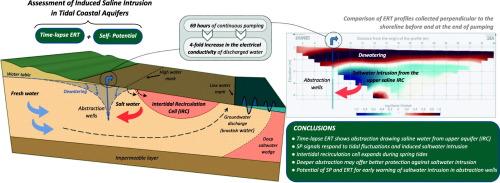
Excessive groundwater abstraction in coastal areas exacerbates saltwater intrusion (SWI), a widespread global issue. Characterization of mechanisms delivering saltwater to wells can assist in developing suitable SWI mitigation strategies for reducing the risk of groundwater degradation. This paper presents findings from hydrogeological monitoring, time-lapse electrical resistivity tomography (ERT) and self-potential (SP) measurements to investigate SWI under natural and artificially perturbed conditions in a quasi-homogeneous pristine coastal sand aquifer, affected by large tidal ranges (>2 m). Time-lapse ERT surveys conducted under undisturbed conditions identified an upper saline recirculation cell (IRC) beneath the intertidal zone, arising due to seawater infiltrating into an underlying ∼20 m thick sand sequence containing fresher groundwater, with resistivity variations noted between spring and neap tides. Measurements taken during a 69-h constant-rate pumping test, discharging at 10.2 L/s, revealed that pumping drew saline water from the IRC towards abstraction wells. This resulted in saltwater contributions to discharge increasing from 1.4 to 4.1 %, consistent with the decrease in resistivity detected in ERT profiles between 3 m and 7 m below surface. Over the same period, SP signals fell by between 20 and 30 mV with greater declines occurring at locations nearer to the high-water mark. Monitoring data suggest that these changes in SP are primarily due to saline water intrusion from the IRC, rather than pressure changes resulting from pumping. Research findings provide further evidence that SP monitoring could act as a key geophysical early warning parameter for SWI, while ERT data further highlight the potential for monitoring SWI in shallow coastal aquifers. This study also demonstrates that optimal groundwater abstraction strategies in tidal-influenced coastal aquifers can be achieved by targeting deeper zones.
沿海含水层砂实验诱导盐水侵入的时移电阻率成像与自电位监测
沿海地区过度抽取地下水加剧了海水入侵(SWI),这是一个普遍存在的全球性问题。描述向井中输送盐水的机制有助于制定适当的SWI缓解战略,以减少地下水退化的风险。本文介绍了水文地质监测、时移电阻率层析成像(ERT)和自电位(SP)测量的结果,以研究受大潮汐差(>2 m)影响的准均匀原始沿海砂含水层在自然和人为干扰条件下的SWI。在未受干扰的条件下进行的时移电阻率层析成像(ERT)调查发现了潮间带下方的上层盐水再循环单元(IRC)。由于海水渗透到含有较新鲜地下水的下伏~ 20 m厚砂层序中,在春潮和小潮之间有电阻率变化。在69小时的恒速泵送测试中,以10.2 L/s的排量进行了测量,结果表明,泵送将IRC中的盐水抽到抽水井中。这导致海水对排放量的贡献从1.4%增加到4.1%,这与ERT剖面在地表以下3 m至7 m之间检测到的电阻率下降一致。在同一时期,SP信号下降了20到30毫伏,更大的下降发生在接近高水位线的地方。监测数据表明,这些SP的变化主要是由于IRC的盐水侵入,而不是泵送引起的压力变化。研究结果进一步证明SP监测可以作为SWI的关键地球物理预警参数,而ERT数据进一步强调了在浅海含水层监测SWI的潜力。该研究还表明,在受潮汐影响的沿海含水层中,可以通过瞄准更深的区域来实现最佳的地下水抽取策略。
本文章由计算机程序翻译,如有差异,请以英文原文为准。
求助全文
约1分钟内获得全文
求助全文
来源期刊

Science of the Total Environment
环境科学-环境科学
CiteScore
17.60
自引率
10.20%
发文量
8726
审稿时长
2.4 months
期刊介绍:
The Science of the Total Environment is an international journal dedicated to scientific research on the environment and its interaction with humanity. It covers a wide range of disciplines and seeks to publish innovative, hypothesis-driven, and impactful research that explores the entire environment, including the atmosphere, lithosphere, hydrosphere, biosphere, and anthroposphere.
The journal's updated Aims & Scope emphasizes the importance of interdisciplinary environmental research with broad impact. Priority is given to studies that advance fundamental understanding and explore the interconnectedness of multiple environmental spheres. Field studies are preferred, while laboratory experiments must demonstrate significant methodological advancements or mechanistic insights with direct relevance to the environment.
 求助内容:
求助内容: 应助结果提醒方式:


