{"title":"Machine learning-guided integration of fixed and mobile sensors for high resolution urban PM2.5 mapping","authors":"Tianshuai Li, Xin Huang, Qingzhu Zhang, Xinfeng Wang, Xianfeng Wang, Anbao Zhu, Zhaolin Wei, Xinyan Wang, Haolin Wang, Jiaqi Chen, Min Li, Qiao Wang, Wenxing Wang","doi":"10.1038/s41612-025-00984-3","DOIUrl":null,"url":null,"abstract":"<p>Urban areas exhibit significant gradients in Fine Particulate Matter (PM<sub>2.5</sub>) concentration variability. Understanding the spatiotemporal distribution and formation mechanisms of PM<sub>2.5</sub> is crucial for public health, environmental justice, and air pollution mitigation strategies. Here, we utilized machine learning and integrated air quality sensor monitoring networks consisting of 200 mobile cruising vehicles and 614 fixed micro–stations to reconstruct PM<sub>2.5</sub> pollution maps for Jinan’s urban area with a high spatiotemporal resolution of 500 m and 1 h. Our study demonstrated that pollution mapping can effectively capture spatiotemporal variations at the urban microscale. By optimizing the spatial design of monitoring networks, we developed a cost-effective air quality monitoring strategy that reduces expenses by nearly 70% while maintaining high precision. The results of multi-model coupling indicated that secondary inorganic aerosols were the primary driving factors for PM2.5 pollution in Jinan. Our work offers a unique perspective on urban air quality monitoring and pollution attribution.</p>","PeriodicalId":19438,"journal":{"name":"npj Climate and Atmospheric Science","volume":"71 1","pages":""},"PeriodicalIF":8.5000,"publicationDate":"2025-03-10","publicationTypes":"Journal Article","fieldsOfStudy":null,"isOpenAccess":false,"openAccessPdf":"","citationCount":"0","resultStr":null,"platform":"Semanticscholar","paperid":null,"PeriodicalName":"npj Climate and Atmospheric Science","FirstCategoryId":"89","ListUrlMain":"https://doi.org/10.1038/s41612-025-00984-3","RegionNum":1,"RegionCategory":"地球科学","ArticlePicture":[],"TitleCN":null,"AbstractTextCN":null,"PMCID":null,"EPubDate":"","PubModel":"","JCR":"Q1","JCRName":"METEOROLOGY & ATMOSPHERIC SCIENCES","Score":null,"Total":0}
引用次数: 0
Abstract
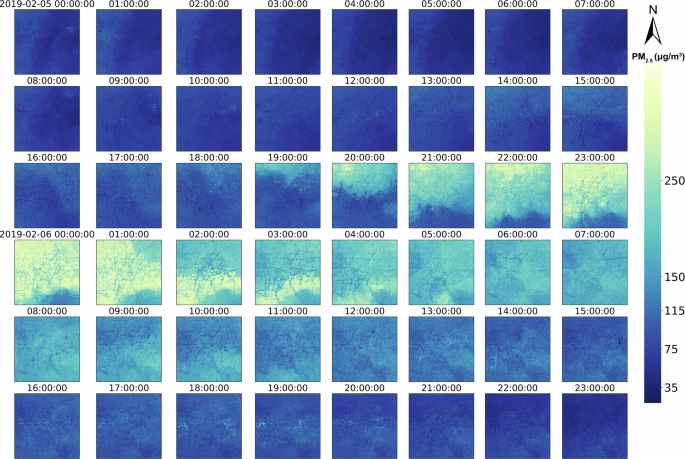
Urban areas exhibit significant gradients in Fine Particulate Matter (PM2.5) concentration variability. Understanding the spatiotemporal distribution and formation mechanisms of PM2.5 is crucial for public health, environmental justice, and air pollution mitigation strategies. Here, we utilized machine learning and integrated air quality sensor monitoring networks consisting of 200 mobile cruising vehicles and 614 fixed micro–stations to reconstruct PM2.5 pollution maps for Jinan’s urban area with a high spatiotemporal resolution of 500 m and 1 h. Our study demonstrated that pollution mapping can effectively capture spatiotemporal variations at the urban microscale. By optimizing the spatial design of monitoring networks, we developed a cost-effective air quality monitoring strategy that reduces expenses by nearly 70% while maintaining high precision. The results of multi-model coupling indicated that secondary inorganic aerosols were the primary driving factors for PM2.5 pollution in Jinan. Our work offers a unique perspective on urban air quality monitoring and pollution attribution.
期刊介绍:
npj Climate and Atmospheric Science is an open-access journal encompassing the relevant physical, chemical, and biological aspects of atmospheric and climate science. The journal places particular emphasis on regional studies that unveil new insights into specific localities, including examinations of local atmospheric composition, such as aerosols.
The range of topics covered by the journal includes climate dynamics, climate variability, weather and climate prediction, climate change, ocean dynamics, weather extremes, air pollution, atmospheric chemistry (including aerosols), the hydrological cycle, and atmosphere–ocean and atmosphere–land interactions. The journal welcomes studies employing a diverse array of methods, including numerical and statistical modeling, the development and application of in situ observational techniques, remote sensing, and the development or evaluation of new reanalyses.
 求助内容:
求助内容: 应助结果提醒方式:


