Forecasting deforestation and carbon loss across New Guinea using machine learning and cellular automata
IF 8
1区 环境科学与生态学
Q1 ENVIRONMENTAL SCIENCES
引用次数: 0
Abstract
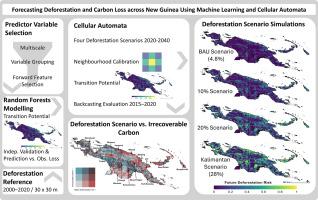
The island of New Guinea harbors some of the world's most biologically diverse and highly endemic tropical ecosystems. Nevertheless, progressing land-use change in the region threatens their integrity, which will adversely affect their biodiversity as well as carbon stocks and fluxes. Our objectives were to (1) compare deforestation drivers between Indonesian New Guinea and Papua New Guinea, (2) identify areas with a high risk of future deforestation under different development scenarios, and (3) evaluate the effects of potential deforestation scenarios on carbon pools. We integrated machine learning and cellular automata to model and forecast deforestation across New Guinea. We assessed the potential loss of irrecoverable carbon stocks for four deforestation scenarios ranging from 4.8 % (business-as-usual) to 28 % (high development scenario) forest loss between 2020 and 2040. Areas of high deforestation risk were consistently forecasted in lowland regions across the four deforestation scenarios. In Indonesian New Guinea, 75 % of deforestation was forecasted below ~380 m a.s.l., but ranged higher in Papua New Guinea (<750 m a.s.l.). Land change-induced carbon loss varied largely across the four scenarios and ranged between 156 and 918 Mt in Indonesian New Guinea and between 223 and 1082 Mt in Papua New Guinea, respectively. Our analysis reveals promising potential for integrating random forests and cellular automata models to forecast high-resolution deforestation over large spatial extents. Our models reveal the vulnerability of New Guinea's lowlands to future deforestation, emphasizing the need to protect key areas where deforestation conflicts with the conservation of carbon stocks, ecosystem functions, and biodiversity.
Abstract in Bahasa Indonesia
Pulau New Guinea merupakan rumah bagi beberapa ekosistem tropis yang paling beragam secara biologis dan sangat endemik di dunia. Namun demikian, perubahan penggunaan lahan yang terus terjadi di kawasan ini mengancam integritas kawasan tersebut, yang akan berdampak buruk terhadap keanekaragaman hayati serta persdiaan dan fluks karbon. Tujuan penelitian ini adalah (1) membandingkan penyebab deforestasi antara New Guinea dan Papua Nugini, (2) mengidentifikasi kawasan dengan risiko tinggi deforestasi di masa depan berdasarkan skenario pembangunan yang berbeda, dan (3) mengevaluasi dampak skenario deforestasi potensial terhadap sumber karbon. . Kami mengintegrasikan pembelajaran mesin dan automata seluler untuk memodelkan dan memperkirakan deforestasi di seluruh New Guinea. Kami menilai potensi hilangnya cadangan karbon yang tidak dapat dipulihkan untuk empat skenario deforestasi yang berkisar antara 4,8 % (skenario pembangunan biasa) hingga 28 % (skenario pembangunan tinggi) antara tahun 2020 dan 2040. Wilayah dengan risiko deforestasi tinggi secara konsisten diperkirakan berada di wilayah dataran rendah dalam empat skenario deforestasi. Di Papua Nugini, 75 % deforestasi diperkirakan berada di bawah ~380 m dpl, namun berkisar lebih tinggi di Papua Nugini (<750 m dpl). Hilangnya karbon yang disebabkan oleh perubahan lahan sangat bervariasi di keempat skenario dan berkisar antara 156 dan 918 Mt di Nugini, dan masing-masing antara 223 dan 1.082 Mt di Papua Nugini. Analisis kami mengungkapkan potensi yang menjanjikan untuk mengintegrasikan hutan acak dan model automata seluler untuk memperkirakan deforestasi resolusi tinggi pada wilayah spasial yang luas. Model kami mengungkap bahwa kerentanan dataran rendah New Guinea terhadap deforestasi di masa depan, menekankan perlunya melindungi wilayah-wilayah utama di mana deforestasi bertentangan dengan konservasi persediaan karbon, fungsi ekosistem, dan keanekaragaman hayati.
利用机器学习和细胞自动机预测新几内亚的森林砍伐和碳损失
新几内亚岛拥有世界上生物多样性最丰富、最具地方特色的热带生态系统。然而,该地区土地使用的不断变化威胁着它们的完整性,这将对其生物多样性以及碳储量和碳通量产生不利影响。我们的目标是:(1) 比较印度尼西亚新几内亚和巴布亚新几内亚的森林砍伐驱动因素;(2) 识别在不同发展情景下未来森林砍伐风险较高的地区;(3) 评估潜在森林砍伐情景对碳库的影响。我们整合了机器学习和细胞自动机,对整个新几内亚的森林砍伐情况进行建模和预测。我们评估了 2020 年至 2040 年间四种森林砍伐情景下不可恢复碳储量的潜在损失,森林损失率从 4.8%(一切照旧)到 28%(高度发展情景)不等。在四种森林砍伐情景下,预测的高森林砍伐风险地区均位于低地地区。在印度尼西亚新几内亚,预计 75% 的森林砍伐发生在海拔约 380 米以下的地区,但在巴布亚新几内亚,这一比例更高(海拔<750 米)。土地变化引起的碳损失在四种情景中差别很大,在印度尼西亚新几内亚分别为 1.56 亿吨和 9.18 亿吨,在巴布亚新几内亚分别为 2.23 亿吨和 1.082 亿吨。我们的分析揭示了集成随机森林和细胞自动机模型预测大空间范围内高分辨率森林砍伐的巨大潜力。我们的模型揭示了新几内亚低地在未来森林砍伐面前的脆弱性,强调了保护森林砍伐与碳储量、生态系统功能和生物多样性保护相冲突的关键区域的必要性。然而,该地区持续的土地利用变化威胁着生态系统的完整性,对生物多样性、碳储量和碳通量产生了不利影响。本研究的目标是:(1)比较新几内亚和巴布亚新几内亚森林砍伐的驱动因素;(2)确定在不同发展情景下未来森林砍伐的高风险地区;(3)评估潜在森林砍伐情景对碳储量的影响。.我们整合了机器学习和细胞自动机,对整个新几内亚的森林砍伐情况进行建模和预测。我们评估了 2020 年至 2040 年间四种森林砍伐情景下碳储量的潜在不可逆损失,其范围从 4.8%(典型发展情景)到 28%(高度发展情景)不等。据估计,在四种森林砍伐情景下,森林砍伐风险一直较高的地区均位于低洼地区。在巴布亚新几内亚,估计 75% 的毁林发生在海拔约 380 米以下的地区,但巴布亚新几内亚的范围更大(海拔<750 米)。土地变化造成的碳损失在四种情景中差别很大,在新几内亚分别为 1.56 亿吨到 9.18 亿吨,在巴布亚新几内亚分别为 2.23 亿吨到 10.82 亿吨。我们的分析揭示了整合随机森林模型和细胞自动机模型以估算大面积高分辨率森林砍伐的巨大潜力。我们的模型揭示了新几内亚低地在未来森林砍伐面前的脆弱性,强调有必要保护森林砍伐与碳储量、生态系统功能和生物多样性保护相冲突的关键地区。
本文章由计算机程序翻译,如有差异,请以英文原文为准。
求助全文
约1分钟内获得全文
求助全文
来源期刊

Science of the Total Environment
环境科学-环境科学
CiteScore
17.60
自引率
10.20%
发文量
8726
审稿时长
2.4 months
期刊介绍:
The Science of the Total Environment is an international journal dedicated to scientific research on the environment and its interaction with humanity. It covers a wide range of disciplines and seeks to publish innovative, hypothesis-driven, and impactful research that explores the entire environment, including the atmosphere, lithosphere, hydrosphere, biosphere, and anthroposphere.
The journal's updated Aims & Scope emphasizes the importance of interdisciplinary environmental research with broad impact. Priority is given to studies that advance fundamental understanding and explore the interconnectedness of multiple environmental spheres. Field studies are preferred, while laboratory experiments must demonstrate significant methodological advancements or mechanistic insights with direct relevance to the environment.
 求助内容:
求助内容: 应助结果提醒方式:


