Multi-sensor missile-borne LiDAR point cloud data augmentation based on Monte Carlo distortion simulation
Abstract
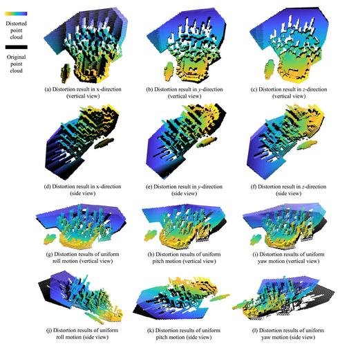
Large-scale point cloud datasets form the basis for training various deep learning networks and achieving high-quality network processing tasks. Due to the diversity and robustness constraints of the data, data augmentation (DA) methods are utilised to expand dataset diversity and scale. However, due to the complex and distinct characteristics of LiDAR point cloud data from different platforms (such as missile-borne and vehicular LiDAR data), directly applying traditional 2D visual domain DA methods to 3D data can lead to networks trained using this approach not robustly achieving the corresponding tasks. To address this issue, the present study explores DA for missile-borne LiDAR point cloud using a Monte Carlo (MC) simulation method that closely resembles practical application. Firstly, the model of multi-sensor imaging system is established, taking into account the joint errors arising from the platform itself and the relative motion during the imaging process. A distortion simulation method based on MC simulation for augmenting missile-borne LiDAR point cloud data is proposed, underpinned by an analysis of combined errors between different modal sensors, achieving high-quality augmentation of point cloud data. The effectiveness of the proposed method in addressing imaging system errors and distortion simulation is validated using the imaging scene dataset constructed in this paper. Comparative experiments between the proposed point cloud DA algorithm and the current state-of-the-art algorithms in point cloud detection and single object tracking tasks demonstrate that the proposed method can improve the network performance obtained from unaugmented datasets by over 17.3% and 17.9%, surpassing SOTA performance of current point cloud DA algorithms.


 求助内容:
求助内容: 应助结果提醒方式:


