Land subsidence in coastal reclamation with impact on metro operation under rapid urbanization: A case study of Shenzhen
IF 8
1区 环境科学与生态学
Q1 ENVIRONMENTAL SCIENCES
引用次数: 0
Abstract
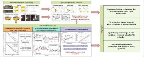
With rapid urbanization in coastal cities, the sharp increase in coastal reclamation due to human activity has caused serious land subsidence problems and threatened the safety of urban traffic in reclamation areas, especially in fast developing cities, such as Shenzhen. However, the spatio-temporal distribution of reclamation evolution and land subsidence to assist in metro operations on a regional scale remain under-explored. To fill-in this research gap, an attempt was made to monitor the coastal reclamation dynamics of Shenzhen from 1979 to 2020.The spatial-temporal changes in the reclamation were discussed based on the Landsat 5, 7 and 8 datasets along with urban growth for a 40-year period. Accordingly, the fill height distribution was employed using available global DEM datasets to perform land fill height effect of metro system in the reclamation area. After understanding the spatial-temporal patterns of land reclamation changes, we focused on monitoring the land subsidence in reclamation area using time-series Sentinel-1 Interferometric SAR (InSAR) datasets by SVD and Stacking techniques. 48 scenes were acquired during ascending and descending passes respectively between 8/3/2015 to 8/8/2023 for the study area. The field measurements of metro deformation in reclamation area acquired from investigation data reflects the risk level of metro operational risk of urban traffic. In-depth analysis of reclamation characteristics revealed a direct relationship between urban expansion, land subsidence and metro deformation. A high correlation coefficient of 0.89 was observed between land subsidence variation and the metro deformation measured along metro line 2 and line 11 in reclamation area. Understanding the impact of land subsidence on metro operation is key to refining sustainable urban development in reclamation areas.
快速城市化条件下海岸带填海造地沉降对地铁运行的影响——以深圳为例
随着沿海城市城市化的快速发展,人类活动导致的沿海填海工程急剧增加,造成了严重的地面沉降问题,威胁着填海地区的城市交通安全,特别是在深圳等快速发展的城市。然而,在区域尺度上,填海演变和地面沉降的时空分布对地铁运营的帮助仍未得到充分探索。为了填补这一研究空白,本文尝试对1979 - 2020年深圳沿海填海动态进行监测。基于Landsat 5、7和8卫星数据,分析了40年城市发展过程中填海造地的时空变化特征。利用现有全球DEM数据集,利用填土高度分布对填海区内地铁系统进行填土高度效应分析。在了解土地复垦变化时空格局的基础上,利用Sentinel-1干涉SAR (InSAR)时间序列数据,采用SVD和叠加技术对复垦区地面沉降进行了监测。研究区在2015年8月3日至2023年8月8日期间,分别在上升通道和下降通道获取了48个场景。根据调查资料获得的围垦区地铁变形的现场测量值反映了城市交通地铁运营风险的风险程度。通过对填海特征的深入分析,揭示了城市扩张、地面沉降与地铁变形之间的直接关系。填海区地铁2号线、11号线沿线地面沉降变化与地铁变形的相关系数为0.89。了解地面沉降对地铁运营的影响是完善填海地区城市可持续发展的关键。
本文章由计算机程序翻译,如有差异,请以英文原文为准。
求助全文
约1分钟内获得全文
求助全文
来源期刊

Science of the Total Environment
环境科学-环境科学
CiteScore
17.60
自引率
10.20%
发文量
8726
审稿时长
2.4 months
期刊介绍:
The Science of the Total Environment is an international journal dedicated to scientific research on the environment and its interaction with humanity. It covers a wide range of disciplines and seeks to publish innovative, hypothesis-driven, and impactful research that explores the entire environment, including the atmosphere, lithosphere, hydrosphere, biosphere, and anthroposphere.
The journal's updated Aims & Scope emphasizes the importance of interdisciplinary environmental research with broad impact. Priority is given to studies that advance fundamental understanding and explore the interconnectedness of multiple environmental spheres. Field studies are preferred, while laboratory experiments must demonstrate significant methodological advancements or mechanistic insights with direct relevance to the environment.
 求助内容:
求助内容: 应助结果提醒方式:


