Anabelle W Cardoso, Erin L Hestir, Jasper A Slingsby, Cherie J Forbes, Glenn R Moncrieff, Woody Turner, Andrew L Skowno, Jacob Nesslage, Philip G Brodrick, Keith D Gaddis, Adam M Wilson
{"title":"The biodiversity survey of the Cape (BioSCape), integrating remote sensing with biodiversity science.","authors":"Anabelle W Cardoso, Erin L Hestir, Jasper A Slingsby, Cherie J Forbes, Glenn R Moncrieff, Woody Turner, Andrew L Skowno, Jacob Nesslage, Philip G Brodrick, Keith D Gaddis, Adam M Wilson","doi":"10.1038/s44185-024-00071-5","DOIUrl":null,"url":null,"abstract":"<p><p>There are repeated calls for remote sensing observations to produce accessible data products that improve our understanding and conservation of biodiversity. The Biodiversity Survey of the Cape (BioSCape) addresses this need by integrating field, airborne, satellite, and modeling datasets to advance the limits of global remote sensing of biodiversity. Over six weeks, an international team of ~150 scientists collected data across terrestrial, marine, and freshwater ecosystems in South Africa. In situ biodiversity observations of plant and animal communities, estuaries, kelp, and plankton were made using traditional field methods as well as novel approaches like environmental DNA and acoustic surveys. Biodiversity observations were accompanied by an unprecedented combination of airborne imaging spectroscopy and lidar measurements acquired across 45,000 km<sup>2</sup>. Here, we review how the approaches applied in BioSCape will help us measure and monitor biodiversity at scale and the role of remote sensing in accomplishing this.</p>","PeriodicalId":520249,"journal":{"name":"npj biodiversity","volume":"4 1","pages":"2"},"PeriodicalIF":0.0000,"publicationDate":"2025-02-03","publicationTypes":"Journal Article","fieldsOfStudy":null,"isOpenAccess":false,"openAccessPdf":"https://www.ncbi.nlm.nih.gov/pmc/articles/PMC11790483/pdf/","citationCount":"0","resultStr":null,"platform":"Semanticscholar","paperid":null,"PeriodicalName":"npj biodiversity","FirstCategoryId":"1085","ListUrlMain":"https://doi.org/10.1038/s44185-024-00071-5","RegionNum":0,"RegionCategory":null,"ArticlePicture":[],"TitleCN":null,"AbstractTextCN":null,"PMCID":null,"EPubDate":"","PubModel":"","JCR":"","JCRName":"","Score":null,"Total":0}
引用次数: 0
Abstract
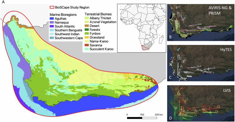
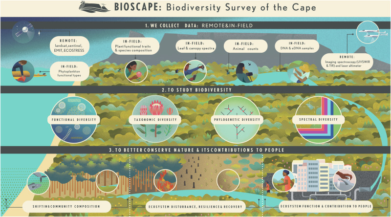
There are repeated calls for remote sensing observations to produce accessible data products that improve our understanding and conservation of biodiversity. The Biodiversity Survey of the Cape (BioSCape) addresses this need by integrating field, airborne, satellite, and modeling datasets to advance the limits of global remote sensing of biodiversity. Over six weeks, an international team of ~150 scientists collected data across terrestrial, marine, and freshwater ecosystems in South Africa. In situ biodiversity observations of plant and animal communities, estuaries, kelp, and plankton were made using traditional field methods as well as novel approaches like environmental DNA and acoustic surveys. Biodiversity observations were accompanied by an unprecedented combination of airborne imaging spectroscopy and lidar measurements acquired across 45,000 km2. Here, we review how the approaches applied in BioSCape will help us measure and monitor biodiversity at scale and the role of remote sensing in accomplishing this.

 求助内容:
求助内容: 应助结果提醒方式:


