Airborne geophysical analysis to decipher salinization for coastal Louisiana
IF 12.4
1区 环境科学与生态学
Q1 ENGINEERING, ENVIRONMENTAL
引用次数: 0
Abstract
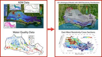
Coastal Louisiana is known for saltwater intrusion that threatens wetlands, aquifers, and rivers. However, the extent of saltwater intrusion is not well understood. This study develops an innovative framework with airborne electromagnetic (AEM) data to map chloride concentration distributions for wetlands in the Mississippi River deltaic plain and Chenier plain as well as for the Mississippi River Valley alluvial aquifer (MRVA) and Chicot aquifer. Moreover, the framework maps chloride concentrations along the Mississippi River and Atchafalaya River. Key components in the framework include the establishment of resistivity-to-chloride concentration transformation, 3D resistivity architecture building through geostatistics, and the employment of a lithologic model. The transformation functions correlate AEM resistivity data with porewater salinity measurements and groundwater and river chloride samples. The results show that AEM data reliably infers soil water chloride concentrations and correlates well with the distribution of various marsh types. AEM data reveals extensive saltwater presence at depth and near the coast, originating from salt domes and the Gulf of Mexico, respectively. The saltwater upconing pattern in the Chicot aquifer is likely due to excessive groundwater withdrawals. The AEM data also confirms a distinct tongue of saltwater intruding into the Atchafalaya Basin from the Gulf. The AEM data helps to identify faults that are obscured or eroded at the surface, which appear as leaky barriers in the subsurface where dramatic changes in chloride concentration are apparent. Finally, this study uses the AEM data to infer the presence of an extensive seawater wedge in the Mississippi River and Atchafalaya River.

航空地球物理分析破译路易斯安那沿海盐碱化
路易斯安那州沿海地区因咸水入侵而闻名,这些咸水威胁着湿地、含水层和河流。然而,海水入侵的程度尚不清楚。本研究利用机载电磁(AEM)数据开发了一个创新的框架,用于绘制密西西比河三角洲平原和切尼尔平原湿地以及密西西比河流域冲积含水层(MRVA)和奇科特含水层的氯化物浓度分布。此外,该框架还绘制了密西西比河和阿查法拉亚河沿岸的氯化物浓度图。该框架的关键组成部分包括建立电阻率-氯离子浓度转换,通过地质统计学建立三维电阻率结构,以及采用岩性模型。转换函数将AEM电阻率数据与孔隙水盐度测量以及地下水和河流氯化物样品相关联。结果表明,AEM数据可靠地推断了土壤水氯浓度,并与各种沼泽类型的分布具有良好的相关性。AEM数据显示,深海和海岸附近存在大量盐水,分别来自盐丘和墨西哥湾。Chicot含水层的盐水上涌模式可能是由于地下水过度抽取造成的。AEM数据还证实了一个明显的盐水舌从海湾侵入Atchafalaya盆地。AEM数据有助于识别地表被遮蔽或侵蚀的断层,这些断层在地下表现为泄漏屏障,氯离子浓度变化明显。最后,本研究使用AEM数据来推断密西西比河和阿查法拉亚河中存在广泛的海水楔。
本文章由计算机程序翻译,如有差异,请以英文原文为准。
求助全文
约1分钟内获得全文
求助全文
来源期刊
Water Research
环境科学-工程:环境
CiteScore
20.80
自引率
9.40%
发文量
1307
审稿时长
38 days
期刊介绍:
Water Research, along with its open access companion journal Water Research X, serves as a platform for publishing original research papers covering various aspects of the science and technology related to the anthropogenic water cycle, water quality, and its management worldwide. The audience targeted by the journal comprises biologists, chemical engineers, chemists, civil engineers, environmental engineers, limnologists, and microbiologists. The scope of the journal include:
•Treatment processes for water and wastewaters (municipal, agricultural, industrial, and on-site treatment), including resource recovery and residuals management;
•Urban hydrology including sewer systems, stormwater management, and green infrastructure;
•Drinking water treatment and distribution;
•Potable and non-potable water reuse;
•Sanitation, public health, and risk assessment;
•Anaerobic digestion, solid and hazardous waste management, including source characterization and the effects and control of leachates and gaseous emissions;
•Contaminants (chemical, microbial, anthropogenic particles such as nanoparticles or microplastics) and related water quality sensing, monitoring, fate, and assessment;
•Anthropogenic impacts on inland, tidal, coastal and urban waters, focusing on surface and ground waters, and point and non-point sources of pollution;
•Environmental restoration, linked to surface water, groundwater and groundwater remediation;
•Analysis of the interfaces between sediments and water, and between water and atmosphere, focusing specifically on anthropogenic impacts;
•Mathematical modelling, systems analysis, machine learning, and beneficial use of big data related to the anthropogenic water cycle;
•Socio-economic, policy, and regulations studies.
 求助内容:
求助内容: 应助结果提醒方式:


