Monitoring phycocyanin in global inland waters by remote sensing: Progress and future developments
IF 12.4
1区 环境科学与生态学
Q1 ENGINEERING, ENVIRONMENTAL
引用次数: 0
Abstract
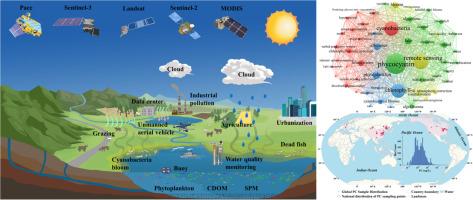
Cyanobacterial blooms are increasingly becoming major threats to global inland aquatic ecosystems. Phycocyanin (PC), a pigment unique to cyanobacteria, can provide important reference for the study of cyanobacterial blooms warning. New satellite technology and cloud computing platforms have greatly improved research on PC, with the average number of studies examining it having increased from 5 per year before 2018 to 17 per year thereafter. Many empirical, semi-empirical, semi-analytical, quasi-analytical algorithm (QAA) and machine learning (ML) algorithms have been developed based on unique absorption characteristics of PC at approximately 620 nm. However, most models have been developed for individual lakes or clusters of them in specific regions, and their applicability at greater spatial scales requires evaluation. A review of optical mechanisms, principles and advantages and disadvantages of different model types, performance advantages and disadvantages of mainstream sensors in PC remote sensing inversion, and an evaluation of global lacustrine PC datasets is needed. We examine 230 articles from the Web of Science citation database between 1900 and 2024, summarize 57 of them that deal with construction of PC inversion models, and compile a list of 6526 PC sampling sites worldwide. This review proposed the key to achieving global lacustrine PC remote sensing inversion and spatiotemporal evolution analysis is to fully use existing multi-source remote sensing big data platforms, and a deep combination of ML and optical mechanisms, to classify the object lakes in advance based on lake optical characteristics, eutrophication level, water depth, climate type, altitude, population density within the watershed. Additionally, integrating data from multi-source satellite sensors, ground-based observations, and unmanned aerial vehicles, will enable future development of global lacustrine PC remote estimation, and contribute to achieving United Nations Sustainable Development Goals inland water goals.


遥感监测全球内陆水域藻蓝蛋白:进展和未来发展
蓝藻华日益成为全球内陆水生生态系统的主要威胁。藻蓝蛋白(PC)是一种蓝藻特有的色素,可为蓝藻华预警研究提供重要参考。新的卫星技术和云计算平台大大提高了对个人电脑的研究,研究个人电脑的平均研究数量从2018年之前的每年5项增加到2018年之后的每年17项。许多经验、半经验、半解析、准解析算法(QAA)和机器学习(ML)算法基于PC在约620nm的独特吸收特性被开发出来。然而,大多数模式都是针对特定区域的单个湖泊或湖泊群开发的,它们在更大空间尺度上的适用性有待评估。综述了不同模型类型的光学机理、原理和优缺点,主流传感器在PC遥感反演中的性能优缺点,并对全球湖泊PC数据集进行了评价。本文分析了Web of Science数据库1900年至2024年间的230篇论文,总结了57篇涉及PC反演模型构建的论文,并列出了全球6526个PC采样点。本文提出,充分利用现有多源遥感大数据平台,深度结合ML与光学机制,根据湖泊光学特征、富营养化程度、水深、气候类型、海拔高度、流域内人口密度等因素,对目标湖泊进行预先分类,是实现全球湖泊PC遥感反演与时空演变分析的关键。此外,整合来自多源卫星传感器、地面观测和无人机的数据,将使全球湖泊PC遥感估算的未来发展成为可能,并有助于实现联合国内陆水可持续发展目标。
本文章由计算机程序翻译,如有差异,请以英文原文为准。
求助全文
约1分钟内获得全文
求助全文
来源期刊

Water Research
环境科学-工程:环境
CiteScore
20.80
自引率
9.40%
发文量
1307
审稿时长
38 days
期刊介绍:
Water Research, along with its open access companion journal Water Research X, serves as a platform for publishing original research papers covering various aspects of the science and technology related to the anthropogenic water cycle, water quality, and its management worldwide. The audience targeted by the journal comprises biologists, chemical engineers, chemists, civil engineers, environmental engineers, limnologists, and microbiologists. The scope of the journal include:
•Treatment processes for water and wastewaters (municipal, agricultural, industrial, and on-site treatment), including resource recovery and residuals management;
•Urban hydrology including sewer systems, stormwater management, and green infrastructure;
•Drinking water treatment and distribution;
•Potable and non-potable water reuse;
•Sanitation, public health, and risk assessment;
•Anaerobic digestion, solid and hazardous waste management, including source characterization and the effects and control of leachates and gaseous emissions;
•Contaminants (chemical, microbial, anthropogenic particles such as nanoparticles or microplastics) and related water quality sensing, monitoring, fate, and assessment;
•Anthropogenic impacts on inland, tidal, coastal and urban waters, focusing on surface and ground waters, and point and non-point sources of pollution;
•Environmental restoration, linked to surface water, groundwater and groundwater remediation;
•Analysis of the interfaces between sediments and water, and between water and atmosphere, focusing specifically on anthropogenic impacts;
•Mathematical modelling, systems analysis, machine learning, and beneficial use of big data related to the anthropogenic water cycle;
•Socio-economic, policy, and regulations studies.
 求助内容:
求助内容: 应助结果提醒方式:


