Frank Dickmann, Julian Keil, Annika Korte, Dennis Edler, Denise O Meara, Martin Bordewieck, Nikolai Axmacher
{"title":"Improved Navigation Performance Through Memory Triggering Maps: A <i>Neurocartographic</i> Approach.","authors":"Frank Dickmann, Julian Keil, Annika Korte, Dennis Edler, Denise O Meara, Martin Bordewieck, Nikolai Axmacher","doi":"10.1007/s42489-024-00181-x","DOIUrl":null,"url":null,"abstract":"<p><p>When using navigation devices the \"cognitive map\" created in the user's mind is much more fragmented, incomplete and inaccurate, compared to the mental model of space created when reading a conventional printed map. As users become more dependent on digital devices that reduce orientation skills, there is an urgent need to develop more efficient navigation systems that promote orientation skills. This paper proposes to consider brain processes for creating more efficient maps that use a network of optimally located cardinal lines and landmarks organized to support and stabilize the neurocognitive structures in the brain that promote spatial orientation. This new approach combines neurocognitive insights with classical research on the efficiency of cartographic visualizations. Recent neuroscientific findings show that spatially tuned neurons could be linked to navigation processes. In particular, the activity of grid cells, which appear to be used to process metric information about space, can be influenced by environmental stimuli such as walls or boundaries. Grid cell activity could be used to create a new framework for map-based interfaces that primarily considers the brain structures associated with the encoding and retrieval of spatial information. The new framework proposed in this paper suggests to arrange map symbols in a specific way that the map design helps to stabilize grid cell firing in the brain and by this improve spatial orientation and navigational performance. Spatially oriented cells are active in humans not only when moving in space, but also when imagining moving through an area-such as when reading a map. It seems likely that the activity of grid cells can be stabilized simply by map symbols that are perceived when reading a map.</p>","PeriodicalId":36860,"journal":{"name":"KN - Journal of Cartography and Geographic Information","volume":"74 3-4","pages":"251-266"},"PeriodicalIF":0.0000,"publicationDate":"2024-01-01","publicationTypes":"Journal Article","fieldsOfStudy":null,"isOpenAccess":false,"openAccessPdf":"https://www.ncbi.nlm.nih.gov/pmc/articles/PMC11659358/pdf/","citationCount":"0","resultStr":null,"platform":"Semanticscholar","paperid":null,"PeriodicalName":"KN - Journal of Cartography and Geographic Information","FirstCategoryId":"1085","ListUrlMain":"https://doi.org/10.1007/s42489-024-00181-x","RegionNum":0,"RegionCategory":null,"ArticlePicture":[],"TitleCN":null,"AbstractTextCN":null,"PMCID":null,"EPubDate":"2024/12/3 0:00:00","PubModel":"Epub","JCR":"Q1","JCRName":"Earth and Planetary Sciences","Score":null,"Total":0}
引用次数: 0
Abstract
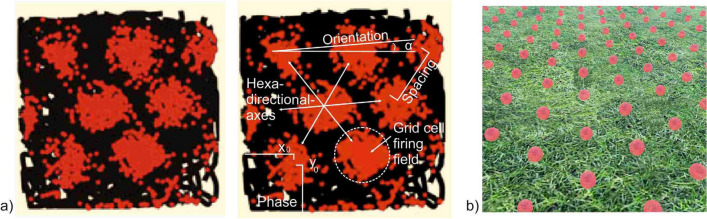
When using navigation devices the "cognitive map" created in the user's mind is much more fragmented, incomplete and inaccurate, compared to the mental model of space created when reading a conventional printed map. As users become more dependent on digital devices that reduce orientation skills, there is an urgent need to develop more efficient navigation systems that promote orientation skills. This paper proposes to consider brain processes for creating more efficient maps that use a network of optimally located cardinal lines and landmarks organized to support and stabilize the neurocognitive structures in the brain that promote spatial orientation. This new approach combines neurocognitive insights with classical research on the efficiency of cartographic visualizations. Recent neuroscientific findings show that spatially tuned neurons could be linked to navigation processes. In particular, the activity of grid cells, which appear to be used to process metric information about space, can be influenced by environmental stimuli such as walls or boundaries. Grid cell activity could be used to create a new framework for map-based interfaces that primarily considers the brain structures associated with the encoding and retrieval of spatial information. The new framework proposed in this paper suggests to arrange map symbols in a specific way that the map design helps to stabilize grid cell firing in the brain and by this improve spatial orientation and navigational performance. Spatially oriented cells are active in humans not only when moving in space, but also when imagining moving through an area-such as when reading a map. It seems likely that the activity of grid cells can be stabilized simply by map symbols that are perceived when reading a map.
期刊介绍:
KN - Journal of Cartography and Geographic Information is dedicated to theoretical, applied and empirical approaches of cartography and geovisualization. We understand cartography as a science and technique to analyze, visualize and communicate spatial information. Cartography is the cross-over discipline in the field of spatial and geo sciences, including geoinformation science. Cartography addresses spatial questions from a variety of disciplines, including geography, environmental sciences and social sciences, using methods and tools developed at the interface with neighboring domains such as geodesy, GI Science, and spatial cognition.These questions can put different emphasis on theoretical fundamentals, methods, techniques and applications.KN - Journal of Cartography and Geographic Information is the only cartographic journal of the German language area. The journal is among the oldest cartographic periodicals worldwide. It was established in 1951 as the journal of the German Society of Cartography (DGfK). In 1976, the journal has become the joint periodical publication of DGfK, the Cartographic Commission of the Austrian Geographical Society (ÖKK), and the Swiss Cartographic Society (SGK).The journal publishes four issues per year. All articles are peer-reviewed. Furthermore, there are short articles on recent technical developments in practical applications with geodata. The journal reports on national as well as international conferences and other events concerning the above-mentioned fields. Supplementary sections comprise regular accounts of the activities in the German, Austrian and Swiss cartographic societies and business news from private-sector-companies, government agencies and academia. In addition, there are book reviews and a calendar of cartographically relevant events. Since 2009, the journal is indexed in Scopus.
 求助内容:
求助内容: 应助结果提醒方式:


