Satellite-Based Monitoring of Methane Emissions from China’s Rice Hub
IF 10.8
1区 环境科学与生态学
Q1 ENGINEERING, ENVIRONMENTAL
引用次数: 0
Abstract
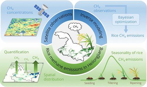
Rice cultivation is one of the major anthropogenic methane sources in China and globally. However, accurately quantifying regional rice methane emissions is often challenging due to highly heterogeneous emission fluxes and limited measurement data. This study attempts to address this issue by quantifying regional methane emissions from rice cultivation with a high-resolution inversion of satellite methane observations from the Tropospheric Monitoring Instrument (TROPOMI). We apply the method to the largest rice-producing province (Heilongjiang) in China for 2021. Our satellite-based estimation finds a rice methane emission of 0.85 (0.69–1.03) Tg a–1 from the province or an average emission factor of 22.0 (17.8–26.6) g m–2 a–1 when normalized by rice paddy areas. The satellite-based analysis reveals a 2 to 4 times lower bias in widely used global and national inventories, which lack up-to-date regional information. The inversion reduces the uncertainty of regional rice emissions by 73% relative to bottom-up estimates based on field flux measurements. The satellite inversion also shows that the highest rice methane emissions occur in June during the tillering stage of rice, decreasing toward ripening, indicating that the predominant water management practice in the region involves drainage and intermittent flooding after initial flooding. Process-based modeling further suggests that this practice can lead to a reduction of methane emissions by more than 50% compared to continuous flooding of rice paddies and natural wetlands.
基于卫星的中国水稻中心甲烷排放监测
水稻种植是中国乃至全球主要的人为甲烷源之一。然而,由于排放通量高度不均匀和测量数据有限,准确量化区域稻米甲烷排放量往往具有挑战性。本研究试图通过对流层监测仪器(TROPOMI)卫星甲烷观测数据的高分辨率反演来量化水稻种植的区域甲烷排放,从而解决这一问题。我们将该方法应用于2021年中国最大的水稻生产省(黑龙江)。我们基于卫星的估算发现,该省水稻甲烷排放量为0.85 (0.69-1.03)Tg a - 1,按稻田面积归一化后的平均排放因子为22.0 (17.8-26.6)g m-2 a - 1。基于卫星的分析显示,在广泛使用的缺乏最新区域信息的全球和国家清单中,偏差降低了2至4倍。与基于田间通量测量的自下而上估算相比,反演将区域水稻排放的不确定性降低了73%。卫星反演还显示,水稻分蘖期的6月甲烷排放量最高,随着水稻成熟逐渐减少,表明该地区主要的水资源管理方式是排水和初次淹水后的间歇性淹水。基于过程的模型进一步表明,与稻田和天然湿地的持续淹水相比,这种做法可使甲烷排放量减少50%以上。
本文章由计算机程序翻译,如有差异,请以英文原文为准。
求助全文
约1分钟内获得全文
求助全文
来源期刊
环境科学与技术
环境科学-工程:环境
CiteScore
17.50
自引率
9.60%
发文量
12359
审稿时长
2.8 months
期刊介绍:
Environmental Science & Technology (ES&T) is a co-sponsored academic and technical magazine by the Hubei Provincial Environmental Protection Bureau and the Hubei Provincial Academy of Environmental Sciences.
Environmental Science & Technology (ES&T) holds the status of Chinese core journals, scientific papers source journals of China, Chinese Science Citation Database source journals, and Chinese Academic Journal Comprehensive Evaluation Database source journals. This publication focuses on the academic field of environmental protection, featuring articles related to environmental protection and technical advancements.
 求助内容:
求助内容: 应助结果提醒方式:


