Budi Handoyo, Hadi Soekamto, Alfyananda K Putra, Puspita A Kamil, Fajar Wulandari
{"title":"Disaster preparedness: The role of spatial disaster learning using geospatial technology.","authors":"Budi Handoyo, Hadi Soekamto, Alfyananda K Putra, Puspita A Kamil, Fajar Wulandari","doi":"10.4102/jamba.v16i1.1576","DOIUrl":null,"url":null,"abstract":"<p><p>Preparedness for natural disasters is crucial for people living in high-risk areas along the Ring of Fire, such as people in Indonesia. Although Spatial Disaster Learning using Geospatial Technology (SDL-GeoTech) has been developed, its effectiveness in enhancing students' preparedness remains unproven. This study examines the impact of SDL-GeoTech on junior high school students' readiness using a quasi-experimental, time-series, single-group pre-post-test design. The research involved students from three schools: SMA 1 Grati Pasuruan (flood-prone), SMA 1 Puncu Kediri (volcanic eruption-prone), and SMA 3 Mataram Lombok (earthquake-prone). Data were collected through tests on knowledge, skills, and attitudes, followed by <i>t</i>-test analysis at a 0.05 significance level. The results of this study show SDL-GeoTech was significantly able to improve students' preparedness, including their knowledge, skills, and attitudes. These findings highlight SDL-GeoTech as an innovative tool for disaster education, with the potential to enhance curricula and teaching strategies, especially in vulnerable areas.</p><p><strong>Contribution: </strong>This research teaches students to use techno-geospatial learning through SDL-GeoTech, equipping those in the Ring of Fire region to be better prepared for potential natural disasters such as earthquakes and floods. The proven analysis of SDL-GeoTech has shown that it enhances students' knowledge, skills and attitude in preparedness in dealing with disasters.</p>","PeriodicalId":51823,"journal":{"name":"Jamba-Journal of Disaster Risk Studies","volume":"16 1","pages":"1576"},"PeriodicalIF":1.7000,"publicationDate":"2024-11-08","publicationTypes":"Journal Article","fieldsOfStudy":null,"isOpenAccess":false,"openAccessPdf":"https://www.ncbi.nlm.nih.gov/pmc/articles/PMC11621869/pdf/","citationCount":"0","resultStr":null,"platform":"Semanticscholar","paperid":null,"PeriodicalName":"Jamba-Journal of Disaster Risk Studies","FirstCategoryId":"1085","ListUrlMain":"https://doi.org/10.4102/jamba.v16i1.1576","RegionNum":0,"RegionCategory":null,"ArticlePicture":[],"TitleCN":null,"AbstractTextCN":null,"PMCID":null,"EPubDate":"2024/1/1 0:00:00","PubModel":"eCollection","JCR":"Q2","JCRName":"SOCIAL SCIENCES, INTERDISCIPLINARY","Score":null,"Total":0}
引用次数: 0
Abstract
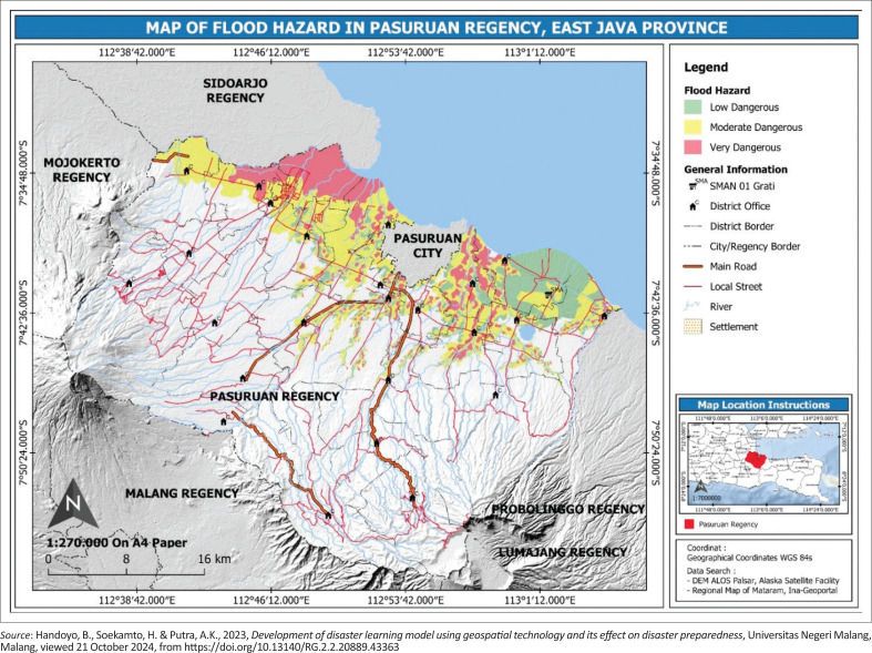
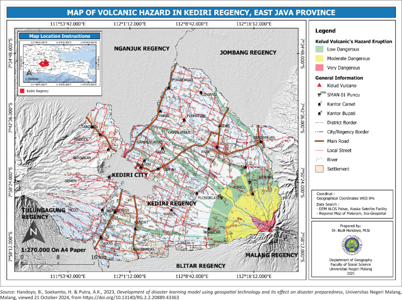
Preparedness for natural disasters is crucial for people living in high-risk areas along the Ring of Fire, such as people in Indonesia. Although Spatial Disaster Learning using Geospatial Technology (SDL-GeoTech) has been developed, its effectiveness in enhancing students' preparedness remains unproven. This study examines the impact of SDL-GeoTech on junior high school students' readiness using a quasi-experimental, time-series, single-group pre-post-test design. The research involved students from three schools: SMA 1 Grati Pasuruan (flood-prone), SMA 1 Puncu Kediri (volcanic eruption-prone), and SMA 3 Mataram Lombok (earthquake-prone). Data were collected through tests on knowledge, skills, and attitudes, followed by t-test analysis at a 0.05 significance level. The results of this study show SDL-GeoTech was significantly able to improve students' preparedness, including their knowledge, skills, and attitudes. These findings highlight SDL-GeoTech as an innovative tool for disaster education, with the potential to enhance curricula and teaching strategies, especially in vulnerable areas.
Contribution: This research teaches students to use techno-geospatial learning through SDL-GeoTech, equipping those in the Ring of Fire region to be better prepared for potential natural disasters such as earthquakes and floods. The proven analysis of SDL-GeoTech has shown that it enhances students' knowledge, skills and attitude in preparedness in dealing with disasters.


 求助内容:
求助内容: 应助结果提醒方式:


