Identifying TSM dynamics in arid inland lakes combining satellite imagery and wind speed
IF 5.9
1区 地球科学
Q1 ENGINEERING, CIVIL
引用次数: 0
Abstract
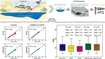
The Chah Nimeh Reservoirs (CNRs), located in Iran’s Sistan region, are critical arid inland lakes that support agriculture and supply drinking water to the region. A major concern regarding water quality in these reservoirs is the concentration of Total Suspended Matter (TSM), which has significant implications for both the local communities and the aquatic ecosystem. This study demonstrates the complicated connection between wind speed and TSM values, indicating that wind speed is an essential variable influencing TSM concentrations. By combining in-situ wind measurements with satellite imagery, we mapped TSM distributions using empirically derived models. Our investigation identified the Long Short-Term Memory (LSTM) and Attention-Mechanism-Based Dynamic Inner Partial Least Squares Long Short-Term Memory (ADiPLS-LSTM) models as effective predictors of TSM levels. Specifically, two distinct machine learning models were utilized: Rrs2TSM, which relies solely on Remote Sensing Reflectance (Rrs(λ)), and the more advanced Rrs&Wind2TSM, which incorporates both Rrs(λ) and wind data. The ADiPLS-LSTM model generated results with minimal variance, showing exceptional consistency. The Root Mean Square Error (RMSE) remains low at 0.617, while the R2 value maintained continually elevated at 0.997. It’s interesting to note that modest variations in TSM concentrations occurred when wind speed data was incorporated into the algorithm, especially during times of greater wind speeds. This study emphasizes the significant impact of wind speed on TSM dynamics in arid inland lakes, showcasing the value of satellite imagery in conducting such analyses. The findings provide essential insights for developing strategies that promote sustainable water resource management.

结合卫星影像和风速识别干旱内陆湖的TSM动态
Chah Nimeh水库(CNRs)位于伊朗的锡斯坦地区,是重要的干旱内陆湖泊,为该地区提供农业支持和饮用水。这些水库中水质的一个主要问题是总悬浮物(TSM)的浓度,这对当地社区和水生生态系统都有重大影响。研究表明,风速与TSM值之间存在复杂的联系,表明风速是影响TSM浓度的重要变量。通过将现场风测量与卫星图像相结合,我们利用经验推导的模型绘制了TSM分布。本研究发现长短期记忆(LSTM)和基于注意机制的动态内偏最小二乘长短期记忆(ADiPLS-LSTM)模型是TSM水平的有效预测因子。具体来说,使用了两种不同的机器学习模型:Rrs2TSM,它只依赖于遥感反射率(Rrs(λ)),以及更先进的Rrs&;Wind2TSM,它结合了Rrs(λ)和风数据。ADiPLS-LSTM模型生成的结果方差最小,具有优异的一致性。均方根误差(RMSE)保持在0.617的低位,而R2值保持在0.997的高位。有趣的是,当风速数据被纳入算法时,TSM浓度会发生适度的变化,尤其是在风速较大的时候。本研究强调了风速对干旱内陆湖泊TSM动态的显著影响,展示了卫星图像在进行此类分析中的价值。研究结果为制定促进可持续水资源管理的战略提供了重要见解。
本文章由计算机程序翻译,如有差异,请以英文原文为准。
求助全文
约1分钟内获得全文
求助全文
来源期刊

Journal of Hydrology
地学-地球科学综合
CiteScore
11.00
自引率
12.50%
发文量
1309
审稿时长
7.5 months
期刊介绍:
The Journal of Hydrology publishes original research papers and comprehensive reviews in all the subfields of the hydrological sciences including water based management and policy issues that impact on economics and society. These comprise, but are not limited to the physical, chemical, biogeochemical, stochastic and systems aspects of surface and groundwater hydrology, hydrometeorology and hydrogeology. Relevant topics incorporating the insights and methodologies of disciplines such as climatology, water resource systems, hydraulics, agrohydrology, geomorphology, soil science, instrumentation and remote sensing, civil and environmental engineering are included. Social science perspectives on hydrological problems such as resource and ecological economics, environmental sociology, psychology and behavioural science, management and policy analysis are also invited. Multi-and interdisciplinary analyses of hydrological problems are within scope. The science published in the Journal of Hydrology is relevant to catchment scales rather than exclusively to a local scale or site.
 求助内容:
求助内容: 应助结果提醒方式:


