Sedimentary and geomorphological evolution of a young tidal flat in the northern part of the Po delta (Italy)
IF 2.6
3区 地球科学
Q1 MARINE & FRESHWATER BIOLOGY
引用次数: 0
Abstract
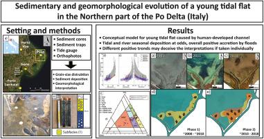
Due to anthropic activities of the last centuries, coastal wetlands worldwide lost wide portions of salt marshes. Since these ecosystems provide fundamental services and benefits to both natural and anthropic components, the natural restoration of these habitats is becoming one of the main objectives of these days, and the opening of new connections between land and sea is becoming a highly used technique to restore portions of intertidal areas. According to recent studies based on analysis of long-term satellite imagery datasets and bathymetric surveys, the Po River Delta (Northern Italy) is currently subjected to a positive sedimentation trend and a constructive process is ongoing at the main river branches. Following an evolution similar to restoration projects, new tidal flats are building up around the tip of the delta, where agricultural fields were inundated by strong floods in the 1950s and the 1960s. This study focuses on a young tidal flat of about 8 ha, located in the Southernmost part of the Barbamarco lagoon. Sediment granulometric distribution and sedimentary pattern were investigated between May 2019 and March 2021 through coring, sediment traps, and orthophotos. The results show that the system is undergoing a progradation and an extended crevasse splay is developing. This covers the central part of the flat and it has developed from the early 2000s, due to human intervention on levees as well as river floods. The levees of the eastern channel stabilized between 2008 and 2012 thanks to vegetation growth, allowing the floods to focus in the NW direction, leading to the development of this recent feature. The presence of the crevasse splay confirms the importance of the river floods on the tidal flat formation. The calculated depositional rates suggest that sedimentation is higher during summer (average 66.89 g/m2 per submersion event) and lower during winter (18.86–20.65 g/m2 per submersion event). These trends are opposite to the seasonal trends observed in the literature, showing that the deposition controlled by the tide is lower compared to the river influence and suggesting that the river is the dominant factor.

波河三角洲北部年轻潮滩的沉积和地貌演变(意大利)
由于过去几个世纪的人类活动,世界各地的沿海湿地失去了大片盐沼。由于这些生态系统为自然和人类提供了基本服务和利益,自然恢复这些栖息地正成为当今的主要目标之一,而打通陆地和海洋之间的新联系正成为恢复部分潮间带的常用技术。根据最近基于长期卫星图像数据集分析和水深测量调查的研究,波河三角洲(意大利北部)目前正处于积极的沉积趋势,主要河流支流的建设过程正在进行中。在经历了与修复项目类似的演变之后,三角洲顶端周围正在形成新的滩涂,在 20 世纪 50 年代和 60 年代,这里的农田曾被强大的洪水淹没。本研究的重点是位于巴巴马科泻湖最南端的一片约 8 公顷的年轻滩涂。在 2019 年 5 月至 2021 年 3 月期间,通过取芯、沉积物捕集器和正射影像对沉积物颗粒分布和沉积模式进行了调查。研究结果表明,该系统正在经历一个渐进过程,并且正在形成一个延伸的裂缝斜面。它覆盖了平地的中部,从 2000 年代初开始形成,原因是人为干预堤坝以及河水泛滥。由于植被的生长,东部河道的堤坝在 2008 年至 2012 年期间趋于稳定,洪水得以向西北方向集中,从而形成了这一最新地貌。裂缝飞溅的存在证实了河水对潮汐平地形成的重要性。计算得出的沉积速率表明,夏季沉积量较高(平均 66.89 克/平方米/次),冬季沉积量较低(18.86-20.65 克/平方米/次)。这些趋势与文献中观察到的季节性趋势相反,表明潮汐控制的沉积作用低于河流的影响,并表明河流是主导因素。
本文章由计算机程序翻译,如有差异,请以英文原文为准。
求助全文
约1分钟内获得全文
求助全文
来源期刊
CiteScore
5.60
自引率
7.10%
发文量
374
审稿时长
9 months
期刊介绍:
Estuarine, Coastal and Shelf Science is an international multidisciplinary journal devoted to the analysis of saline water phenomena ranging from the outer edge of the continental shelf to the upper limits of the tidal zone. The journal provides a unique forum, unifying the multidisciplinary approaches to the study of the oceanography of estuaries, coastal zones, and continental shelf seas. It features original research papers, review papers and short communications treating such disciplines as zoology, botany, geology, sedimentology, physical oceanography.

 求助内容:
求助内容: 应助结果提醒方式:


