Landslide risk assessment by integrating hazards and vulnerability indices in Southeast Bangladesh
IF 4.2
1区 地球科学
Q1 GEOSCIENCES, MULTIDISCIPLINARY
International journal of disaster risk reduction
Pub Date : 2024-11-01
DOI:10.1016/j.ijdrr.2024.104991
引用次数: 0
Abstract
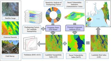
Landslide risk assessment (LRA) is crucial to develop sustainable risk reduction and response measures. Although Southeast Bangladesh is prone to landslides, there is insufficient comprehensive investigation that incorporates susceptibility and vulnerability assessments with LRA. This study first calculated the Landslide Susceptibility Index (LSI) using the frequency ratio (FR), verified it using the ROC-AUC curve, and then measured the Social Vulnerability Index (SoVI) using Principal Component Analysis (PCA). Finally, the research integrated the LSI and SoVI map by normalizing and weighting to compute a Landslide Risk Index (LRI) map. The region's LSI reveals 10.19 % very high, 28.10 % moderate, and 13.41 % very low landslide susceptibility. According to the FR model, slope, elevation NDVI, and rainfall predispose to landslides. However, the SoVI revealed 39.3 % of Upazilas experienced medium landslide social vulnerability, which is hazard independent. The LRI statistics classify landslide risk as very high (23 %), high (12 %), moderate (28 %), low (20 %), or very low (17 %) for a total area of 19163.53 km2. A district-wise risk analysis ranks landslide risk as Chattogram > Cox's Bazar > Rangamati > Khagrachhari > Bandarban due to short-term or prolonged rainfall, natural drainage changes, unplanned development, deforestation, hydroelectric plant effects, and population growth. The landslide risk is highest in Teknaf, Ukhia, and Ramu Upazilas and lowest in Thanchi, Rowangchhari, Juraichhari, and Langadu. LSI performed satisfactorily with an AUC-based prediction rate of 81.8 % and success rate curve of 87.0 %. Finally, decision-makers can implement this macro-scale regional landslide risk analysis for southeast hilly Bangladesh for developing sustainable risk reduction schemes.

通过综合灾害和脆弱性指数评估孟加拉国东南部的山体滑坡风险
滑坡风险评估(LRA)对于制定可持续的风险降低和应对措施至关重要。虽然孟加拉国东南部容易发生山体滑坡,但将易感性和脆弱性评估与山体滑坡风险评估相结合的综合调查还不够充分。本研究首先使用频率比(FR)计算了滑坡易感性指数(LSI),并使用 ROC-AUC 曲线进行了验证,然后使用主成分分析法(PCA)测量了社会脆弱性指数(SoVI)。最后,研究通过归一化和加权将 LSI 和 SoVI 地图进行整合,计算出滑坡风险指数(LRI)地图。该地区的 LSI 显示出 10.19% 的极高滑坡易发性、28.10% 的中等滑坡易发性和 13.41% 的极低滑坡易发性。根据 FR 模型,坡度、海拔 NDVI 和降雨容易导致滑坡。然而,SoVI 显示 39.3% 的乡具有中等滑坡社会脆弱性,与灾害无关。在总面积为 19163.53 平方公里的土地上,山体滑坡风险统计将山体滑坡风险分为极高(23%)、高(12%)、中等(28%)、低(20%)或极低(17%)。根据地区风险分析,由于短期或长期降雨、自然排水系统变化、无规划开发、森林砍伐、水电站影响和人口增长等原因,山体滑坡风险被列为恰特格勒、考克斯巴扎尔、兰加马蒂、卡格拉奇哈里和班达尔班。特克纳夫(Teknaf)、乌希亚(Ukhia)和拉姆(Ramu)乡的滑坡风险最高,而坦奇(Thanchi)、罗旺奇哈里(Rowangchhari)、朱莱奇哈里(Juraichhari)和兰加都(Langadu)的滑坡风险最低。LSI 的性能令人满意,基于 AUC 的预测率为 81.8%,成功率曲线为 87.0%。最后,决策者可以对孟加拉国东南部丘陵地区进行宏观区域滑坡风险分析,以制定可持续的风险降低计划。
本文章由计算机程序翻译,如有差异,请以英文原文为准。
求助全文
约1分钟内获得全文
求助全文
来源期刊

International journal of disaster risk reduction
GEOSCIENCES, MULTIDISCIPLINARYMETEOROLOGY-METEOROLOGY & ATMOSPHERIC SCIENCES
CiteScore
8.70
自引率
18.00%
发文量
688
审稿时长
79 days
期刊介绍:
The International Journal of Disaster Risk Reduction (IJDRR) is the journal for researchers, policymakers and practitioners across diverse disciplines: earth sciences and their implications; environmental sciences; engineering; urban studies; geography; and the social sciences. IJDRR publishes fundamental and applied research, critical reviews, policy papers and case studies with a particular focus on multi-disciplinary research that aims to reduce the impact of natural, technological, social and intentional disasters. IJDRR stimulates exchange of ideas and knowledge transfer on disaster research, mitigation, adaptation, prevention and risk reduction at all geographical scales: local, national and international.
Key topics:-
-multifaceted disaster and cascading disasters
-the development of disaster risk reduction strategies and techniques
-discussion and development of effective warning and educational systems for risk management at all levels
-disasters associated with climate change
-vulnerability analysis and vulnerability trends
-emerging risks
-resilience against disasters.
The journal particularly encourages papers that approach risk from a multi-disciplinary perspective.
 求助内容:
求助内容: 应助结果提醒方式:


