Error analysis and visualization of 3D geological models of mineral deposits

IF 3.2 2区 地球科学 Q1 GEOLOGY
Yingxian Chen, Huiru Ma, Zhe Zhu, Jiepeng Fu
{"title":"Error analysis and visualization of 3D geological models of mineral deposits","authors":"Yingxian Chen,&nbsp;Huiru Ma,&nbsp;Zhe Zhu,&nbsp;Jiepeng Fu","doi":"10.1016/j.oregeorev.2024.106366","DOIUrl":null,"url":null,"abstract":"<div><div>The accuracy of 3D geological models of mineral deposits has a significant impact on the precision and reliability of mining production decisions. High-precision 3D geological models can provide more accurate geological information of mineral deposits. A scientific error analysis method is proposed to quantify the errors in geological models and visualize these errors by assigning them to geological model entities. The errors in 3D geological models of mineral deposits mainly originate from modeling data and interpolation methods. By analyzing the generation and processing of modeling data, an error model for the modeling data is established. The Kriging interpolation method is used to quantitatively describe the errors in the modeling methods, and these errors are integrated into the 3D geological model. By using Boolean operations, the 3D geological model is combined with the open-pit mine entity model to generate an error-containing mining site model and mined rock model, and to calculate their mining and stripping volumes and errors, achieving error visualization. Using an open-pit coal mine in Inner Mongolia as a case study, the construction of its 3D mineral deposit and mining field models demonstrates the effectiveness and superiority of the proposed method in practical applications, highlighting its importance in improving the accuracy and reliability of mining production decisions.</div></div>","PeriodicalId":19644,"journal":{"name":"Ore Geology Reviews","volume":"175 ","pages":"Article 106366"},"PeriodicalIF":3.2000,"publicationDate":"2024-11-22","publicationTypes":"Journal Article","fieldsOfStudy":null,"isOpenAccess":false,"openAccessPdf":"","citationCount":"0","resultStr":null,"platform":"Semanticscholar","paperid":null,"PeriodicalName":"Ore Geology Reviews","FirstCategoryId":"89","ListUrlMain":"https://www.sciencedirect.com/science/article/pii/S0169136824004992","RegionNum":2,"RegionCategory":"地球科学","ArticlePicture":[],"TitleCN":null,"AbstractTextCN":null,"PMCID":null,"EPubDate":"","PubModel":"","JCR":"Q1","JCRName":"GEOLOGY","Score":null,"Total":0}
引用次数: 0

Abstract

The accuracy of 3D geological models of mineral deposits has a significant impact on the precision and reliability of mining production decisions. High-precision 3D geological models can provide more accurate geological information of mineral deposits. A scientific error analysis method is proposed to quantify the errors in geological models and visualize these errors by assigning them to geological model entities. The errors in 3D geological models of mineral deposits mainly originate from modeling data and interpolation methods. By analyzing the generation and processing of modeling data, an error model for the modeling data is established. The Kriging interpolation method is used to quantitatively describe the errors in the modeling methods, and these errors are integrated into the 3D geological model. By using Boolean operations, the 3D geological model is combined with the open-pit mine entity model to generate an error-containing mining site model and mined rock model, and to calculate their mining and stripping volumes and errors, achieving error visualization. Using an open-pit coal mine in Inner Mongolia as a case study, the construction of its 3D mineral deposit and mining field models demonstrates the effectiveness and superiority of the proposed method in practical applications, highlighting its importance in improving the accuracy and reliability of mining production decisions.
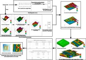
Abstract Image

矿床三维地质模型的误差分析和可视化
矿床三维地质模型的准确性对采矿生产决策的精确性和可靠性有重大影响。高精度三维地质模型可提供更准确的矿床地质信息。本文提出了一种科学的误差分析方法来量化地质模型中的误差,并通过将这些误差分配到地质模型实体中来实现这些误差的可视化。矿床三维地质模型的误差主要来源于建模数据和插值方法。通过分析建模数据的生成和处理过程,建立了建模数据的误差模型。利用克里金插值法对建模方法的误差进行定量描述,并将这些误差整合到三维地质模型中。通过布尔运算,将三维地质模型与露天煤矿实体模型相结合,生成含误差的采场模型和采岩模型,并计算其开采量和剥离量及误差,实现误差可视化。以内蒙古某露天煤矿为例,其三维矿床和采场模型的构建证明了所提方法在实际应用中的有效性和优越性,凸显了其在提高采矿生产决策的准确性和可靠性方面的重要性。
本文章由计算机程序翻译,如有差异,请以英文原文为准。
求助全文
约1分钟内获得全文 求助全文
来源期刊
Ore Geology Reviews
Ore Geology Reviews 地学-地质学
CiteScore
6.50
自引率
27.30%
发文量
546
审稿时长
22.9 weeks
期刊介绍: Ore Geology Reviews aims to familiarize all earth scientists with recent advances in a number of interconnected disciplines related to the study of, and search for, ore deposits. The reviews range from brief to longer contributions, but the journal preferentially publishes manuscripts that fill the niche between the commonly shorter journal articles and the comprehensive book coverages, and thus has a special appeal to many authors and readers.
×
引用
GB/T 7714-2015
复制
MLA
复制
APA
复制
导出至
BibTeX EndNote RefMan NoteFirst NoteExpress
×
提示
您的信息不完整,为了账户安全,请先补充。
现在去补充
×
提示
您因"违规操作"
具体请查看互助需知
我知道了
×
提示
确定
请完成安全验证×
copy
已复制链接
快去分享给好友吧!
我知道了
右上角分享
点击右上角分享
0
联系我们:info@booksci.cn Book学术提供免费学术资源搜索服务,方便国内外学者检索中英文文献。致力于提供最便捷和优质的服务体验。 Copyright © 2023 布克学术 All rights reserved.
京ICP备2023020795号-1
ghs 京公网安备 11010802042870号
Book学术文献互助
Book学术文献互助群
群 号:481959085
Book学术官方微信