Quantification of record-breaking subsidence in California’s San Joaquin Valley
IF 8.1
1区 地球科学
Q1 ENVIRONMENTAL SCIENCES
引用次数: 0
Abstract
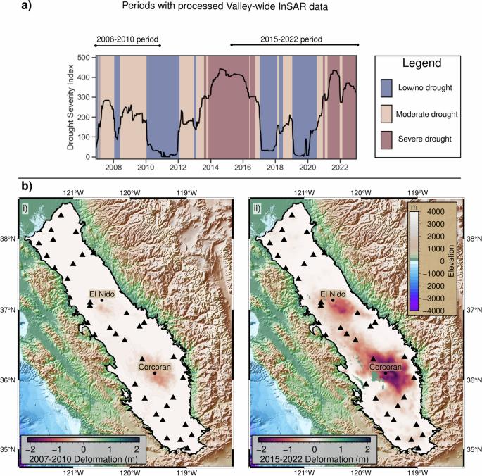
In California’s San Joaquin Valley, groundwater overdraft has caused dramatic and continued land subsidence during two main periods, 1925–1970 (“the historic period”) and post-2006. The impacts of the subsidence are severe, with modified flood risks, damaged aqueducts, and permanently altered aquifer dynamics. However, we do not have a complete record of the post-2006 subsidence due to a 2011–2015 gap in Valley-wide observations, and this makes it difficult to develop an appropriate management response. Here, we used satellite geodetic subsidence measurements to quantify the Valley-wide subsidence volume during 2006–2022. We found a total subsidence volume of 14 km3 over the 16 years, the same as was measured during 24 years of monitoring in the historic period. Considering the extraordinary 2006–2022 Valley-wide subsidence, we make high-level recommendations for subsidence mitigation, highlighting the importance of focusing groundwater overdraft reductions on the deeper aquifers where subsidence originates, and on localities where subsidence impacts are greatest. A remote-sensing based quantification of land subsidence in the San Joaquin Valley, California, finds that recent land subsidence has matched the totals recorded historically, and suggests limiting groundwater withdrawal from deeper parts of the aquifer system.

加州圣华金河谷破纪录的沉降量化
在加利福尼亚州的圣华金河谷,地下水超采造成了 1925-1970 年("历史时期")和 2006 年后两个主要时期持续的急剧地面沉降。地面沉降的影响非常严重,洪水风险增加,输水管道受损,含水层动态永久性改变。然而,由于 2011-2015 年全流域观测的空白,我们没有 2006 年后沉降的完整记录,因此很难制定适当的管理对策。在此,我们利用卫星大地测量沉降测量来量化 2006-2022 年间整个流域的沉降量。我们发现,在这 16 年中,沉降总量为 14 立方公里,与历史时期 24 年的监测结果相同。考虑到 2006-2022 年全流域的异常沉降,我们提出了缓解沉降的高层次建议,强调了将减少地下水超采的重点放在沉降起源的深层含水层和沉降影响最大的地方的重要性。基于遥感技术对加利福尼亚州圣华金河谷的土地沉降进行量化后发现,近期的土地沉降与历史上记录的沉降总量相当,因此建议限制从含水层系统较深的部分抽取地下水。
本文章由计算机程序翻译,如有差异,请以英文原文为准。
求助全文
约1分钟内获得全文
求助全文
来源期刊

Communications Earth & Environment
Earth and Planetary Sciences-General Earth and Planetary Sciences
CiteScore
8.60
自引率
2.50%
发文量
269
审稿时长
26 weeks
期刊介绍:
Communications Earth & Environment is an open access journal from Nature Portfolio publishing high-quality research, reviews and commentary in all areas of the Earth, environmental and planetary sciences. Research papers published by the journal represent significant advances that bring new insight to a specialized area in Earth science, planetary science or environmental science.
Communications Earth & Environment has a 2-year impact factor of 7.9 (2022 Journal Citation Reports®). Articles published in the journal in 2022 were downloaded 1,412,858 times. Median time from submission to the first editorial decision is 8 days.
 求助内容:
求助内容: 应助结果提醒方式:


