Analyzing the structural elements, ecological characteristics, and impact assessment of local green infrastructure in the coastal zone of Estonia
IF 7
2区 环境科学与生态学
Q1 ENVIRONMENTAL SCIENCES
引用次数: 0
Abstract
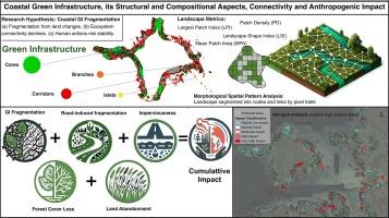
The aim of this study was to address the gaps in understanding and managing the resilience and connectivity of coastal Green Infrastructure (GI) in Estonia, particularly in response to increasing human-related pressures and natural changes.
By using the GUIDOS Toolbox for morphological spatial pattern analysis, the study offers a detailed mapping of the structural patterns of GI across the Estonian coast. The findings highlight significant variations in forest cover, land abandonment, and the spread of impervious surfaces, showing how these changes contribute to the fragmentation of GI.
Our analysis revealed that the Northeast region suffers from severe fragmentation due to extensive industrial activities, whereas the Southwest is predominantly impacted by intensive agriculture, leading to reduced habitat connectivity. Despite having extensive protected areas, the Western Coast displayed large levels of fragmentation, primarily driven by unmanaged land abandonment and encroachment expansion. Specifically, the fragmentation index was highest in the industrialized Northeast and lowest in less developed areas, albeit still significant due to localized human activities. These findings highlight the importance of targeted GI planning that integrates ecological, socio-economic, and spatial dimensions to minimize fragmentation, enhance ecological corridors, and promote sustainable land-use practices. Strategic planning must also account for potential climate change impacts to ensure the resilience and adaptability of GI networks, securing ecosystem services and supporting both ecological and human communities.

分析爱沙尼亚沿海地区地方绿色基础设施的结构要素、生态特征和影响评估
这项研究的目的是解决在了解和管理爱沙尼亚沿海绿色基础设施(GI)的恢复力和连通性方面存在的差距,尤其是在应对日益增加的人为压力和自然变化方面。通过使用 GUIDOS 工具箱进行形态空间模式分析,这项研究提供了爱沙尼亚沿海绿色基础设施结构模式的详细图谱。我们的分析表明,东北部地区由于广泛的工业活动而遭受严重的破碎化,而西南部则主要受到集约农业的影响,导致栖息地的连通性降低。尽管西部沿海地区拥有广阔的保护区,但其破碎化程度却很高,主要原因是无人管理的土地撂荒和侵占扩张。具体而言,工业化东北部的破碎化指数最高,欠发达地区的破碎化指数最低,但由于局部地区的人类活动,破碎化指数仍然很高。这些发现凸显了综合生态、社会经济和空间维度进行有针对性的地理信息系统规划的重要性,以最大限度地减少破碎化、加强生态走廊并促进可持续的土地利用方式。战略规划还必须考虑到潜在的气候变化影响,以确保 GI 网络的复原力和适应性,确保生态系统服务并支持生态和人类社区。
本文章由计算机程序翻译,如有差异,请以英文原文为准。
求助全文
约1分钟内获得全文
求助全文
来源期刊

Ecological Indicators
环境科学-环境科学
CiteScore
11.80
自引率
8.70%
发文量
1163
审稿时长
78 days
期刊介绍:
The ultimate aim of Ecological Indicators is to integrate the monitoring and assessment of ecological and environmental indicators with management practices. The journal provides a forum for the discussion of the applied scientific development and review of traditional indicator approaches as well as for theoretical, modelling and quantitative applications such as index development. Research into the following areas will be published.
• All aspects of ecological and environmental indicators and indices.
• New indicators, and new approaches and methods for indicator development, testing and use.
• Development and modelling of indices, e.g. application of indicator suites across multiple scales and resources.
• Analysis and research of resource, system- and scale-specific indicators.
• Methods for integration of social and other valuation metrics for the production of scientifically rigorous and politically-relevant assessments using indicator-based monitoring and assessment programs.
• How research indicators can be transformed into direct application for management purposes.
• Broader assessment objectives and methods, e.g. biodiversity, biological integrity, and sustainability, through the use of indicators.
• Resource-specific indicators such as landscape, agroecosystems, forests, wetlands, etc.
 求助内容:
求助内容: 应助结果提醒方式:


