Constraining the extent of Greater India: New late Paleocene paleomagnetic data from the Tethyan Himalaya, Tibetan Plateau
IF 7.2
1区 地球科学
Q1 GEOSCIENCES, MULTIDISCIPLINARY
引用次数: 0
Abstract
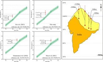
The collision of India and Asia formed the Himalayas and caused the uplift of the Tibetan Plateau. Greater India comprises the part of the Indian plate that was subducted beneath Asia and the Tethyan Himalaya. Quantitative constraints on the extent of Greater India are needed to study the process of the India-Asia collision. However, such constraints are lacking and the topic remains debated. We present paleomagnetic data from late Paleocene (∼58 Ma) mafic rocks from the western Tethyan Himalaya. The mean paleomagnetic direction is Ds/Is = 348.5°/+6.5° with k = 38.7 and a95 = 5.2°, which passed the fold, reversals, and paleosecular variation tests. The results define the paleolatitude of the Tethyan Himalaya as 3.3 ± 4.5°N at ∼ 58 Ma for the reference site of 29.9°N/83.3°E. A comparison of the Paleogene paleolatitudes of the Tethyan Himalaya shows that the terrane moved northward by 1540 ± 290 km between ∼ 60 Ma and ∼ 50 Ma, with a rate of movement of 15.4 ± 2 cm/yr. The new paleomagnetic result confirms that the extent of Greater India was 1130 ± 400 km and was essentially uniform from east to west. This finding implies that the collision between India and Asia was nearly be quasi-synchronous from the middle-eastern to western segments along the Indus-Tsangpo suture zone.

制约大印度的范围:来自青藏高原哲罗喜马拉雅山脉的新的古新世晚期古地磁数据
印度和亚洲的碰撞形成了喜马拉雅山脉,并造成了青藏高原的隆起。大印度板块包括俯冲到亚洲和四叠纪喜马拉雅山之下的印度板块部分。研究印度-亚洲碰撞过程需要对大印度地区的范围进行定量限制。然而,目前还缺乏这样的约束条件,对这一问题仍存在争议。我们展示了来自泰西喜马拉雅西部晚古新世(∼58 Ma)岩浆岩的古地磁数据。平均古地磁方向为Ds/Is = 348.5°/+6.5°,k = 38.7,a95 = 5.2°,通过了褶皱、逆转和古地理变异检验。结果确定了以 29.9°N/83.3°E 为参照地点的哲罗喜马拉雅古纬度为 3.3 ± 4.5°N,时间为 ∼ 58 Ma。通过对比古近纪泰西喜马拉雅山的古纬度,发现该地层在60Ma∼50Ma之间向北移动了1540±290千米,移动速度为15.4±2厘米/年。新的古地磁结果证实,大印度的范围为 1130 ± 400 千米,从东到西基本一致。这一发现意味着印度和亚洲之间的碰撞从印度河-赞普河缝合带的中东部到西部几乎是近乎同步的。
本文章由计算机程序翻译,如有差异,请以英文原文为准。
求助全文
约1分钟内获得全文
求助全文
来源期刊

Gondwana Research
地学-地球科学综合
CiteScore
12.90
自引率
6.60%
发文量
298
审稿时长
65 days
期刊介绍:
Gondwana Research (GR) is an International Journal aimed to promote high quality research publications on all topics related to solid Earth, particularly with reference to the origin and evolution of continents, continental assemblies and their resources. GR is an "all earth science" journal with no restrictions on geological time, terrane or theme and covers a wide spectrum of topics in geosciences such as geology, geomorphology, palaeontology, structure, petrology, geochemistry, stable isotopes, geochronology, economic geology, exploration geology, engineering geology, geophysics, and environmental geology among other themes, and provides an appropriate forum to integrate studies from different disciplines and different terrains. In addition to regular articles and thematic issues, the journal invites high profile state-of-the-art reviews on thrust area topics for its column, ''GR FOCUS''. Focus articles include short biographies and photographs of the authors. Short articles (within ten printed pages) for rapid publication reporting important discoveries or innovative models of global interest will be considered under the category ''GR LETTERS''.
 求助内容:
求助内容: 应助结果提醒方式:


