Rock-ice avalanche-generated erosion behaviors at the Sedongpu gully, Tibet, China: New insights from the geomorphologic perspective
IF 2.7
3区 地球科学
Q2 GEOSCIENCES, MULTIDISCIPLINARY
引用次数: 0
Abstract
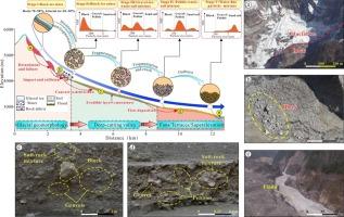
In recent years, massive rock-ice avalanches frequently occur in the Sedongpu gully, forming an extensive dammed lake. Rock-ice avalanches not only threaten residents living in upstream and downstream areas, but also significantly change geomorphology. The gully geomorphology also experienced complicated alterations, due to distal motion distance and strong entrainment of debris flows, coming from the conversion of rock-ice avalanches. This study aims to determine the relation between dynamics erosion of rock-ice avalanches and geomorphology evolution during rock-ice avalanche events at the Sedongpu gully, where a large amount of moraine was distributed with five branch ditches. Field investigations, digital elevation models (DEMs), unmanned aerial vehicles (UAVs), multiphase remote-sensing images, topographic profiling, and InSAR monitoring are carried out to characterise the material changes, including composition, structure, transition, and deposits. Materials were entrained and scraped by debris flows and transported into the Yarlung Zangbo River. The total erosion volume of materials on the valley floor reached 980 million m3 from 2010 to 2021. Topographical profiling suggests that the most severe erosion also occurred in the midstream Sedongpu gully, with the maximum width of above 500 m. The overall elevation of the downstream valley increased by 50 m due to continuous deposits, and formed a large debris fans. The results might be helpful in further studies to reveal dynamic erosion geomorphology of rock-ice avalanches.

中国西藏色季拉沟岩冰雪崩引发的侵蚀行为:地貌学视角的新见解
近年来,色东普沟经常发生大规模的岩冰崩塌,形成了一个大面积的堰塞湖。岩冰崩塌不仅威胁着上游和下游地区的居民,也极大地改变了地貌。由于岩冰崩塌转换产生的远距离运动和泥石流的强烈夹带,沟谷地貌也发生了复杂的变化。本研究旨在确定岩冰崩塌动态侵蚀与岩冰崩塌事件期间四洞铺沟谷地貌演变之间的关系,该沟谷分布着大量冰碛物和五条支沟。通过实地调查、数字高程模型(DEMs)、无人机(UAVs)、多相遥感图像、地形剖面和 InSAR 监测来描述物质变化的特征,包括成分、结构、过渡和沉积。物质被泥石流夹带和刮擦,并被输送到雅鲁藏布江。从 2010 年到 2021 年,谷底物质的侵蚀总量达到 9.8 亿立方米。地形剖面图显示,侵蚀最严重的地方也发生在中游的色东普沟,最大宽度超过 500 米,下游河谷的整体海拔因持续沉积而上升了 50 米,并形成了一个巨大的泥石流扇。这些结果可能有助于进一步研究揭示岩冰崩塌的动态侵蚀地貌。
本文章由计算机程序翻译,如有差异,请以英文原文为准。
求助全文
约1分钟内获得全文
求助全文
来源期刊

Journal of Asian Earth Sciences
地学-地球科学综合
CiteScore
5.90
自引率
10.00%
发文量
324
审稿时长
71 days
期刊介绍:
Journal of Asian Earth Sciences has an open access mirror journal Journal of Asian Earth Sciences: X, sharing the same aims and scope, editorial team, submission system and rigorous peer review.
The Journal of Asian Earth Sciences is an international interdisciplinary journal devoted to all aspects of research related to the solid Earth Sciences of Asia. The Journal publishes high quality, peer-reviewed scientific papers on the regional geology, tectonics, geochemistry and geophysics of Asia. It will be devoted primarily to research papers but short communications relating to new developments of broad interest, reviews and book reviews will also be included. Papers must have international appeal and should present work of more than local significance.
The scope includes deep processes of the Asian continent and its adjacent oceans; seismology and earthquakes; orogeny, magmatism, metamorphism and volcanism; growth, deformation and destruction of the Asian crust; crust-mantle interaction; evolution of life (early life, biostratigraphy, biogeography and mass-extinction); fluids, fluxes and reservoirs of mineral and energy resources; surface processes (weathering, erosion, transport and deposition of sediments) and resulting geomorphology; and the response of the Earth to global climate change as viewed within the Asian continent and surrounding oceans.
 求助内容:
求助内容: 应助结果提醒方式:


