Production viability index for annual agricultural crops
IF 6.1
1区 农林科学
Q1 AGRICULTURE, MULTIDISCIPLINARY
引用次数: 0
Abstract
CONTEXT
In the face of intensifying challenges for sustainable food production, well-planned agricultural development is crucial to mitigate climate impacts and manage blue water demands. Tools and methodologies that support public policy for sustainable regional growth are essential, especially in regions lacking hydroclimatic data, which complicates the use of simulation models for efficient water management. An effective tool should identify areas most suitable for rainfed and irrigated agriculture, optimizing planting dates, crop types, and rotations.
OBJECTIVE
To develop an index to assess the most suitable areas, inside regions, for developing rainfed and irrigated annual crops.
METHODS
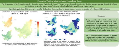
The proposed Production Viability Index (PVI) combines ISDIA (Irrigated Agriculture Suitability Indicator) and ISDRA (Rainfed Agriculture Suitability Indicator) to represent suitability for irrigated and rainfed agriculture. Each indicator comprises five sub-indicators reflecting plant characteristics, soil, climate, and water availability in crop production. A Python routine was developed to calculate the PVI, which was then used to assess soybean production suitability across 204 million hectares in Brazil's Cerrado (Brazilian savannah), the country's second-largest biome. Three planting dates (September 15, October 15, and November 15) were simulated, evaluating the Cerrado's suitability and identifying the best planting date per area.
RESULTS AND CONCLUSIONS
The PVI for Annual Crops proves to be a valuable tool for agricultural planning, enabling the identification of areas with varying suitability for sustainable agricultural development. Based on factors such as climate, soil, plant characteristics, and water availability, the PVI is not intended to determine if a crop can be produced in a specific area but rather to identify locations with greater cultivation potential across different periods and crop types. Results highlight suitability variations throughout the months, underscoring the need for dynamic planning that accounts for seasonality and regional characteristics. Consequently, the PVI significantly supports managers and agricultural planners in developing adaptive strategies, maximizing agricultural productivity and resilience across diverse agro-ecological contexts.
SIGNIFICANCE
This work's primary contribution is the development of an index to classify areas within regions based on rainfed and irrigated agriculture potential, relying on basic, accessible data sets for soil, climate, water, and plant information. These findings aid planners in identifying the most suitable areas for sustainable agricultural expansion, enhancing annual crop production while mitigating water use conflicts.

年度农作物生产可行性指数
内容提要 面对可持续粮食生产日益严峻的挑战,规划合理的农业发展对于减轻气候影响和管理蓝色水需求至关重要。支持区域可持续增长公共政策的工具和方法至关重要,尤其是在缺乏水文气候数据的地区,这使得使用模拟模型进行高效水资源管理变得更加复杂。一个有效的工具应能确定最适合发展雨养和灌溉农业的地区,优化种植日期、作物类型和轮作。每个指标由五个子指标组成,分别反映作物生产中的植物特性、土壤、气候和水供应情况。我们开发了一套 Python 程序来计算 PVI,然后用它来评估巴西第二大生物群落塞拉多(巴西热带草原)2.04 亿公顷土地的大豆生产适宜性。模拟了三个种植日期(9 月 15 日、10 月 15 日和 11 月 15 日),评估了 Cerrado 的适宜性,并确定了每个地区的最佳种植日期。根据气候、土壤、植物特性和水供应等因素,PVI 并不是为了确定特定地区是否可以生产某种作物,而是为了确定不同时期和不同作物类型中种植潜力较大的地区。结果凸显了各个月份的适宜性差异,强调了根据季节性和地区特点进行动态规划的必要性。因此,PVI 可为管理者和农业规划者制定适应性战略提供重要支持,从而在不同的农业生态环境下最大限度地提高农业生产率和抗灾能力。 意义这项工作的主要贡献在于开发了一种指数,可根据雨水灌溉和灌溉农业的潜力对区域内的地区进行分类,该指数依赖于土壤、气候、水和植物信息等基本的、可访问的数据集。这些发现有助于规划者确定最适合可持续农业发展的地区,在提高作物年产量的同时缓解用水冲突。
本文章由计算机程序翻译,如有差异,请以英文原文为准。
求助全文
约1分钟内获得全文
求助全文
来源期刊

Agricultural Systems
农林科学-农业综合
CiteScore
13.30
自引率
7.60%
发文量
174
审稿时长
30 days
期刊介绍:
Agricultural Systems is an international journal that deals with interactions - among the components of agricultural systems, among hierarchical levels of agricultural systems, between agricultural and other land use systems, and between agricultural systems and their natural, social and economic environments.
The scope includes the development and application of systems analysis methodologies in the following areas:
Systems approaches in the sustainable intensification of agriculture; pathways for sustainable intensification; crop-livestock integration; farm-level resource allocation; quantification of benefits and trade-offs at farm to landscape levels; integrative, participatory and dynamic modelling approaches for qualitative and quantitative assessments of agricultural systems and decision making;
The interactions between agricultural and non-agricultural landscapes; the multiple services of agricultural systems; food security and the environment;
Global change and adaptation science; transformational adaptations as driven by changes in climate, policy, values and attitudes influencing the design of farming systems;
Development and application of farming systems design tools and methods for impact, scenario and case study analysis; managing the complexities of dynamic agricultural systems; innovation systems and multi stakeholder arrangements that support or promote change and (or) inform policy decisions.
 求助内容:
求助内容: 应助结果提醒方式:


