Quantifying the influence of topographic amplification on the landslides triggered by the 2015 Gorkha earthquake

IF 8.1 1区 地球科学 Q1 ENVIRONMENTAL SCIENCES
Ashok Dahal, Hakan Tanyas, P. Martin Mai, Mark van der Meijde, Cees van Westen, Luigi Lombardo
{"title":"Quantifying the influence of topographic amplification on the landslides triggered by the 2015 Gorkha earthquake","authors":"Ashok Dahal, Hakan Tanyas, P. Martin Mai, Mark van der Meijde, Cees van Westen, Luigi Lombardo","doi":"10.1038/s43247-024-01822-9","DOIUrl":null,"url":null,"abstract":"Topographic amplification is caused by the interaction between seismic waves and rough terrains. It increases shaking levels on hilltops and could lead stable slopes to the brink of failure. However, its contribution to coseismic landslide occurrence is yet to be quantified over landscapes shaken by strong earthquakes. Here, we examine how topographic amplification controls the spatial distribution of landslides triggered by the 2015 Gorkha earthquake. We find that 6–17% of coseismic failures initiate due to topographic amplification. Among these, only 13% occurred in the vicinity of the rupture zone (<40 km), presumably because proximal slopes fail due to the strong motion, irrespective of topographic amplification. Conversely, the majority of landslides (~60%) due to topographic amplification occur away from the epicentre. Our findings imply that the contribution of topographic amplification is generally overestimated in the case of strong earthquakes, an interpretation that rather holds only far from the rupture zone. The role of topographic amplification of seismic waves on the genesis of co-seismic landslides is overestimated near the rupture zone of large earthquakes where ground motion is high, according to numerical simulations and field observations of the 2015 Mw 7.8 Gorhka earthquake, Nepal.","PeriodicalId":10530,"journal":{"name":"Communications Earth & Environment","volume":" ","pages":"1-10"},"PeriodicalIF":8.1000,"publicationDate":"2024-11-11","publicationTypes":"Journal Article","fieldsOfStudy":null,"isOpenAccess":false,"openAccessPdf":"https://www.nature.com/articles/s43247-024-01822-9.pdf","citationCount":"0","resultStr":null,"platform":"Semanticscholar","paperid":null,"PeriodicalName":"Communications Earth & Environment","FirstCategoryId":"93","ListUrlMain":"https://www.nature.com/articles/s43247-024-01822-9","RegionNum":1,"RegionCategory":"地球科学","ArticlePicture":[],"TitleCN":null,"AbstractTextCN":null,"PMCID":null,"EPubDate":"","PubModel":"","JCR":"Q1","JCRName":"ENVIRONMENTAL SCIENCES","Score":null,"Total":0}
引用次数: 0

Abstract

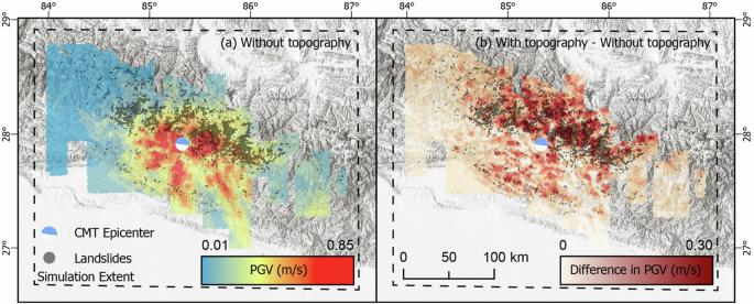
Topographic amplification is caused by the interaction between seismic waves and rough terrains. It increases shaking levels on hilltops and could lead stable slopes to the brink of failure. However, its contribution to coseismic landslide occurrence is yet to be quantified over landscapes shaken by strong earthquakes. Here, we examine how topographic amplification controls the spatial distribution of landslides triggered by the 2015 Gorkha earthquake. We find that 6–17% of coseismic failures initiate due to topographic amplification. Among these, only 13% occurred in the vicinity of the rupture zone (<40 km), presumably because proximal slopes fail due to the strong motion, irrespective of topographic amplification. Conversely, the majority of landslides (~60%) due to topographic amplification occur away from the epicentre. Our findings imply that the contribution of topographic amplification is generally overestimated in the case of strong earthquakes, an interpretation that rather holds only far from the rupture zone. The role of topographic amplification of seismic waves on the genesis of co-seismic landslides is overestimated near the rupture zone of large earthquakes where ground motion is high, according to numerical simulations and field observations of the 2015 Mw 7.8 Gorhka earthquake, Nepal.
Abstract Image

量化地形放大对 2015 年廓尔喀地震引发的山体滑坡的影响
地震波与崎岖地形之间的相互作用会造成地形放大。它增加了山顶的震级,可能导致稳定的斜坡濒临崩塌。然而,在受到强震摇晃的地形中,地形放大对共震滑坡发生的影响还有待量化。在此,我们研究了地形放大如何控制 2015 年廓尔喀地震引发的滑坡的空间分布。我们发现,6%-17% 的共震崩塌是由于地形放大引起的。其中,只有 13% 发生在断裂带附近(<40 km),这可能是因为近端斜坡因强烈运动而崩塌,与地形放大无关。相反,大部分(约 60%)山体滑坡都是在震中以外的地方发生的。我们的研究结果表明,在强震情况下,地形放大的作用通常被高估,这种解释只适用于远离断裂带的地区。根据对尼泊尔 2015 年 7.8 级高尔卡地震的数值模拟和实地观测,地震波的地形放大作用在地面运动较强的大地震破裂带附近被高估,从而导致了共震滑坡的发生。
本文章由计算机程序翻译,如有差异,请以英文原文为准。
求助全文
约1分钟内获得全文 求助全文
来源期刊

Communications Earth & Environment
Communications Earth & Environment Earth and Planetary Sciences-General Earth and Planetary Sciences
CiteScore
8.60
自引率
2.50%
发文量
269
审稿时长
26 weeks
期刊介绍: Communications Earth & Environment is an open access journal from Nature Portfolio publishing high-quality research, reviews and commentary in all areas of the Earth, environmental and planetary sciences. Research papers published by the journal represent significant advances that bring new insight to a specialized area in Earth science, planetary science or environmental science. Communications Earth & Environment has a 2-year impact factor of 7.9 (2022 Journal Citation Reports®). Articles published in the journal in 2022 were downloaded 1,412,858 times. Median time from submission to the first editorial decision is 8 days.
×
引用
GB/T 7714-2015
复制
MLA
复制
APA
复制
导出至
BibTeX EndNote RefMan NoteFirst NoteExpress
×
提示
您的信息不完整,为了账户安全,请先补充。
现在去补充
×
提示
您因"违规操作"
具体请查看互助需知
我知道了
×
提示
确定
请完成安全验证×
copy
已复制链接
快去分享给好友吧!
我知道了
右上角分享
点击右上角分享
0
联系我们:info@booksci.cn Book学术提供免费学术资源搜索服务,方便国内外学者检索中英文文献。致力于提供最便捷和优质的服务体验。 Copyright © 2023 布克学术 All rights reserved.
京ICP备2023020795号-1
ghs 京公网安备 11010802042870号
Book学术文献互助
Book学术文献互助群
群 号:481959085
Book学术官方微信