The delineation of management zones using soil quality indices for the cultivation of irrigated rice (Oryza sativa L.) in Huila, Colombia

IF 3.1 2区 农林科学 Q2 SOIL SCIENCE
John J. Arévalo-Hernández , Eduardo Medeiros de Oliveira , Gabriel Araújo e Silva Ferraz , Diana C. Polanía-Montiel , Anggy L. Liscano Solano , Marx Leandro Naves Silva
{"title":"The delineation of management zones using soil quality indices for the cultivation of irrigated rice (Oryza sativa L.) in Huila, Colombia","authors":"John J. Arévalo-Hernández ,&nbsp;Eduardo Medeiros de Oliveira ,&nbsp;Gabriel Araújo e Silva Ferraz ,&nbsp;Diana C. Polanía-Montiel ,&nbsp;Anggy L. Liscano Solano ,&nbsp;Marx Leandro Naves Silva","doi":"10.1016/j.geodrs.2024.e00886","DOIUrl":null,"url":null,"abstract":"<div><div>Conventional intensive farming systems can result in degraded soil. It is therefore important to monitor this effect periodically by delineating management zones (MZ) based on soil quality indices (SQI) in order to maintain and improve the soil characteristics in a precision farming environment and obtain homogeneous rice yields. The aim of this study was to determine and spatialise SQI and delineate MZ for cultivating flooded rice in an area of Fluvisols in Huila, Colombia. Forty-one georeferenced soil samples were collected from the 0 to 20 cm layer, and the physical, chemical and biological attributes of the soil were analysed to calculate the Integrated Quality Index (IQI) and the Nemoro Quality Index (NQI) using linear scoring functions. Geostatistical tools were then used to fit semivariogram models of the SQI, and interpolated using ordinary kriging to map the MZ using the QGIS software. The IQI and NQI showed a moderate spatial correlation, which allowed three distinct MZ to be identified and delineated. Attributes, such as bulk density (Bd), total porosity (TP), soil respiration (SR), available water (AW) and soil organic matter (SOM) were significant and can be used as a guide by farmers for restoring the quality of the soil in rice production. The method proved to be effective, and provided an information base to be used in the local management of areas of rice cultivation in the study region.</div></div>","PeriodicalId":56001,"journal":{"name":"Geoderma Regional","volume":"39 ","pages":"Article e00886"},"PeriodicalIF":3.1000,"publicationDate":"2024-10-20","publicationTypes":"Journal Article","fieldsOfStudy":null,"isOpenAccess":false,"openAccessPdf":"","citationCount":"0","resultStr":null,"platform":"Semanticscholar","paperid":null,"PeriodicalName":"Geoderma Regional","FirstCategoryId":"97","ListUrlMain":"https://www.sciencedirect.com/science/article/pii/S2352009424001330","RegionNum":2,"RegionCategory":"农林科学","ArticlePicture":[],"TitleCN":null,"AbstractTextCN":null,"PMCID":null,"EPubDate":"","PubModel":"","JCR":"Q2","JCRName":"SOIL SCIENCE","Score":null,"Total":0}
引用次数: 0

Abstract

Conventional intensive farming systems can result in degraded soil. It is therefore important to monitor this effect periodically by delineating management zones (MZ) based on soil quality indices (SQI) in order to maintain and improve the soil characteristics in a precision farming environment and obtain homogeneous rice yields. The aim of this study was to determine and spatialise SQI and delineate MZ for cultivating flooded rice in an area of Fluvisols in Huila, Colombia. Forty-one georeferenced soil samples were collected from the 0 to 20 cm layer, and the physical, chemical and biological attributes of the soil were analysed to calculate the Integrated Quality Index (IQI) and the Nemoro Quality Index (NQI) using linear scoring functions. Geostatistical tools were then used to fit semivariogram models of the SQI, and interpolated using ordinary kriging to map the MZ using the QGIS software. The IQI and NQI showed a moderate spatial correlation, which allowed three distinct MZ to be identified and delineated. Attributes, such as bulk density (Bd), total porosity (TP), soil respiration (SR), available water (AW) and soil organic matter (SOM) were significant and can be used as a guide by farmers for restoring the quality of the soil in rice production. The method proved to be effective, and provided an information base to be used in the local management of areas of rice cultivation in the study region.
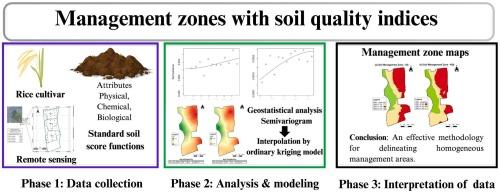
Abstract Image

利用土壤质量指数划分哥伦比亚威拉灌溉水稻(Oryza sativa L.)种植管理区
传统的集约化耕作制度会导致土壤退化。因此,必须根据土壤质量指数(SQI)划定管理区(MZ),定期监测这种影响,以便在精准农业环境中保持和改善土壤特性,获得均匀的水稻产量。本研究的目的是确定 SQI 并将其空间化,为在哥伦比亚威拉的 Fluvisols 地区种植水稻划定管理区。研究人员从 0 至 20 厘米层收集了 41 个地理坐标土壤样本,分析了土壤的物理、化学和生物属性,并使用线性评分函数计算了综合质量指数(IQI)和 Nemoro 质量指数(NQI)。然后使用地质统计工具拟合 SQI 的半变量图模型,并使用普通克里金法进行内插,利用 QGIS 软件绘制 MZ 图。IQI 和 NQI 显示出适度的空间相关性,从而确定并划分出三个不同的 MZ。容重(Bd)、总孔隙度(TP)、土壤呼吸(SR)、可利用水量(AW)和土壤有机质(SOM)等属性都很重要,可作为农民在水稻生产中恢复土壤质量的指导。该方法证明是有效的,并为研究地区水稻种植区的地方管理提供了信息基础。
本文章由计算机程序翻译,如有差异,请以英文原文为准。
求助全文
约1分钟内获得全文 求助全文
来源期刊
Geoderma Regional
Geoderma Regional Agricultural and Biological Sciences-Soil Science
CiteScore
6.10
自引率
7.30%
发文量
122
审稿时长
76 days
期刊介绍: Global issues require studies and solutions on national and regional levels. Geoderma Regional focuses on studies that increase understanding and advance our scientific knowledge of soils in all regions of the world. The journal embraces every aspect of soil science and welcomes reviews of regional progress.
×
引用
GB/T 7714-2015
复制
MLA
复制
APA
复制
导出至
BibTeX EndNote RefMan NoteFirst NoteExpress
×
提示
您的信息不完整,为了账户安全,请先补充。
现在去补充
×
提示
您因"违规操作"
具体请查看互助需知
我知道了
×
提示
确定
请完成安全验证×
copy
已复制链接
快去分享给好友吧!
我知道了
右上角分享
点击右上角分享
0
联系我们:info@booksci.cn Book学术提供免费学术资源搜索服务,方便国内外学者检索中英文文献。致力于提供最便捷和优质的服务体验。 Copyright © 2023 布克学术 All rights reserved.
京ICP备2023020795号-1
ghs 京公网安备 11010802042870号
Book学术文献互助
Book学术文献互助群
群 号:481959085
Book学术官方微信