Hydrogeological modelling of a coastal karst aquifer using an integrated SWAT-MODFLOW approach

IF 4.8 2区 环境科学与生态学 Q1 COMPUTER SCIENCE, INTERDISCIPLINARY APPLICATIONS
Gaetano Daniele Fiorese , Gabriella Balacco , Giovanni Bruno , Nikolaos Nikolaidis
{"title":"Hydrogeological modelling of a coastal karst aquifer using an integrated SWAT-MODFLOW approach","authors":"Gaetano Daniele Fiorese ,&nbsp;Gabriella Balacco ,&nbsp;Giovanni Bruno ,&nbsp;Nikolaos Nikolaidis","doi":"10.1016/j.envsoft.2024.106249","DOIUrl":null,"url":null,"abstract":"<div><div>The complexity of modelling in karst environments necessitates substantial adjustments to existing hydrogeological models, with particular emphasis on accurately representing surface and deep processes.</div><div>This study proposes an advanced methodology for modelling regional coastal karst aquifers using an integrated SWAT-MODFLOW approach. The focus is on the regional coastal karst aquifer of Salento (Italy), which is characterised by significant heterogeneity, anisotropy and data scarcity, such as limited discharge measurements and water levels over time.</div><div>The integrated SWAT - MODFLOW approach allows an accurate description of both surface and subsurface hydrological processes specific to karst environments and demonstrates the adaptability of the models to karst-specific features such as sinkholes, dolines and fault permeability. The study successfully addresses the challenges posed by the distinctive characteristics of karst systems through the integration of SWAT-MODFLOW. Additionally, incorporating of satellite data enhances the precision and dependability of the model by augmenting the traditional datasets.</div><div>The entire simulation period, which included both the calibration and validation phases, extended from 2008 to 2018. The calibration phase occurred between 2008 and 2011, followed by the validation phase between 2015 and 2018. The temporal choices were exclusively based on the availability of meteorological and hydrogeological data. During calibration, satellite data, previous study results, and groundwater level measurements were used to optimize the SWAT and MODFLOW models. Validation subsequently confirmed model accuracy by comparing simulated groundwater levels with observed data, demonstrating a satisfactory root mean square error (RMSE) of 0.22 m. Modelling results indicate that evapotranspiration is the predominant hydrological process, and excessive withdrawals could lead to a water deficit. Simulated piezometric maps provide crucial information on recharge areas and hydraulic compartments delineated by faults. The study not only advances the understanding of the hydrogeology of the specific case study but also provides a valuable reference for future modelling of karst aquifers. Additionally, it highlights the crucial need for ongoing enhancement in the management and monitoring of coastal karst aquifers.</div></div>","PeriodicalId":310,"journal":{"name":"Environmental Modelling & Software","volume":"183 ","pages":"Article 106249"},"PeriodicalIF":4.8000,"publicationDate":"2024-10-17","publicationTypes":"Journal Article","fieldsOfStudy":null,"isOpenAccess":false,"openAccessPdf":"","citationCount":"0","resultStr":null,"platform":"Semanticscholar","paperid":null,"PeriodicalName":"Environmental Modelling & Software","FirstCategoryId":"93","ListUrlMain":"https://www.sciencedirect.com/science/article/pii/S1364815224003104","RegionNum":2,"RegionCategory":"环境科学与生态学","ArticlePicture":[],"TitleCN":null,"AbstractTextCN":null,"PMCID":null,"EPubDate":"","PubModel":"","JCR":"Q1","JCRName":"COMPUTER SCIENCE, INTERDISCIPLINARY APPLICATIONS","Score":null,"Total":0}
引用次数: 0

Abstract

The complexity of modelling in karst environments necessitates substantial adjustments to existing hydrogeological models, with particular emphasis on accurately representing surface and deep processes.
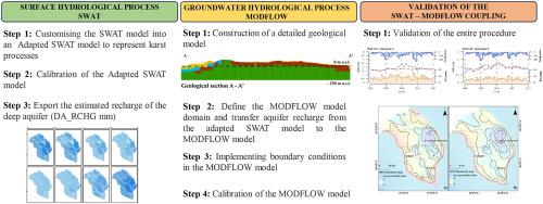
This study proposes an advanced methodology for modelling regional coastal karst aquifers using an integrated SWAT-MODFLOW approach. The focus is on the regional coastal karst aquifer of Salento (Italy), which is characterised by significant heterogeneity, anisotropy and data scarcity, such as limited discharge measurements and water levels over time.
The integrated SWAT - MODFLOW approach allows an accurate description of both surface and subsurface hydrological processes specific to karst environments and demonstrates the adaptability of the models to karst-specific features such as sinkholes, dolines and fault permeability. The study successfully addresses the challenges posed by the distinctive characteristics of karst systems through the integration of SWAT-MODFLOW. Additionally, incorporating of satellite data enhances the precision and dependability of the model by augmenting the traditional datasets.
The entire simulation period, which included both the calibration and validation phases, extended from 2008 to 2018. The calibration phase occurred between 2008 and 2011, followed by the validation phase between 2015 and 2018. The temporal choices were exclusively based on the availability of meteorological and hydrogeological data. During calibration, satellite data, previous study results, and groundwater level measurements were used to optimize the SWAT and MODFLOW models. Validation subsequently confirmed model accuracy by comparing simulated groundwater levels with observed data, demonstrating a satisfactory root mean square error (RMSE) of 0.22 m. Modelling results indicate that evapotranspiration is the predominant hydrological process, and excessive withdrawals could lead to a water deficit. Simulated piezometric maps provide crucial information on recharge areas and hydraulic compartments delineated by faults. The study not only advances the understanding of the hydrogeology of the specific case study but also provides a valuable reference for future modelling of karst aquifers. Additionally, it highlights the crucial need for ongoing enhancement in the management and monitoring of coastal karst aquifers.
Abstract Image

利用 SWAT-MODFLOW 综合方法建立沿海岩溶含水层水文地质模型
岩溶环境建模的复杂性要求对现有的水文地质模型进行重大调整,尤其要强调准确表 现地表和深层过程。本研究提出了一种先进的方法,利用 SWAT-MODFLOW 综合方法对区域性 沿海岩溶含水层进行建模。该研究的重点是意大利萨兰托的区域沿海岩溶含水层,该含水层具有显著的异质性、各向异性和数据稀缺性,如有限的排泄测量数据和随时间变化的水位。SWAT-MODFLOW 集成方法可准确描述岩溶环境特有的地表和地下水文过程,并证明模型可适应岩溶特有的特征,如天坑、溶洞和断层渗透性。这项研究通过集成 SWAT-MODFLOW 成功地应对了岩溶系统的独特特征所带来的挑战。此外,卫星数据的加入还增强了传统数据集,从而提高了模型的精确度和可靠性。校准阶段发生在 2008 年至 2011 年,验证阶段发生在 2015 年至 2018 年。时间选择完全基于气象和水文地质数据的可用性。在校准过程中,利用卫星数据、先前的研究结果和地下水位测量结果来优化 SWAT 和 MODFLOW 模型。随后,通过比较模拟地下水位与观测数据,验证了模型的准确性,结果表明均方根误差 (RMSE) 为 0.22 米,令人满意。模拟压强图提供了有关断层所划定的补给区和水力分区的重要信息。这项研究不仅加深了人们对具体案例研究的水文地质的理解,还为今后岩溶含水层建模提供了宝贵的参考。此外,它还强调了不断加强沿海岩溶含水层管理和监测的重要必要性。
本文章由计算机程序翻译,如有差异,请以英文原文为准。
求助全文
约1分钟内获得全文 求助全文
来源期刊
Environmental Modelling & Software
Environmental Modelling & Software 工程技术-工程:环境
CiteScore
9.30
自引率
8.20%
发文量
241
审稿时长
60 days
期刊介绍: Environmental Modelling & Software publishes contributions, in the form of research articles, reviews and short communications, on recent advances in environmental modelling and/or software. The aim is to improve our capacity to represent, understand, predict or manage the behaviour of environmental systems at all practical scales, and to communicate those improvements to a wide scientific and professional audience.
×
引用
GB/T 7714-2015
复制
MLA
复制
APA
复制
导出至
BibTeX EndNote RefMan NoteFirst NoteExpress
×
提示
您的信息不完整,为了账户安全,请先补充。
现在去补充
×
提示
您因"违规操作"
具体请查看互助需知
我知道了
×
提示
确定
请完成安全验证×
copy
已复制链接
快去分享给好友吧!
我知道了
右上角分享
点击右上角分享
0
联系我们:info@booksci.cn Book学术提供免费学术资源搜索服务,方便国内外学者检索中英文文献。致力于提供最便捷和优质的服务体验。 Copyright © 2023 布克学术 All rights reserved.
京ICP备2023020795号-1
ghs 京公网安备 11010802042870号
Book学术文献互助
Book学术文献互助群
群 号:481959085
Book学术官方微信