Nighttime Street View Imagery: A new perspective for sensing urban lighting landscape
IF 12
1区 工程技术
Q1 CONSTRUCTION & BUILDING TECHNOLOGY
引用次数: 0
Abstract
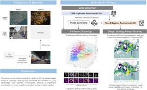
Urban lighting reflects nocturnal activities and it is traditionally observed using Nighttime Lights (NTL) satellite imagery. Few studies systematically measure the nightscape from a human perspective. This study brings a new paradigm — urban lighting sensing via Nighttime Street View Imagery (SVI). The paradigm draws on the accomplishments of (daytime) SVI and gives attention to its ignored nighttime counterpart. We put forward this idea by manually collecting 2,831 nighttime SVIs across various urban functional areas in Singapore. We investigated their values by developing a use case for clustering nighttime lighting patterns. To mitigate the scarcity of nighttime SVI, deep learning regression models were trained to predict nighttime brightness based on corresponding daytime SVIs obtained from widely available sources. The results were compared with brightness data derived from satellite imagery, to affirm the novelty and uniqueness of nighttime SVI. As a result, there are 7 lighting patterns within the collected nighttime SVI, distinct in lighted spot features and total brightness. The identified patterns effectively characterize different urban function scenarios. The best trained brightness prediction model performs well in revealing the city-scale lighting landscape. The SVI-predicted brightness shows a distribution similar to the brightness from satellite imagery and complements it in urban areas with complex vertical lighting structures. This study demonstrates the potential of nighttime SVI as a valuable data source for mapping urban lighting and activities, offering advantages over satellite data. The proposed paradigm contributes significantly to cross-modal information mining in urban studies and has potential applications in scenarios such as light pollution mitigation and crime prevention.
夜间街景图像:感知城市照明景观的新视角
城市照明反映了夜间活动,传统上使用夜间照明(NTL)卫星图像进行观测。很少有研究从人类的角度系统地测量夜景。这项研究带来了一种新模式--通过夜景街景图像(SVI)感知城市照明。该范例借鉴了(白天)SVI 的成就,并关注其被忽视的夜景。我们通过手动收集新加坡各城市功能区的 2,831 幅夜间 SVI 图像,提出了这一想法。我们通过开发夜间照明模式聚类用例来研究其价值。为了减少夜间 SVI 的稀缺性,我们训练了深度学习回归模型,根据从广泛来源获得的相应白天 SVI 预测夜间亮度。预测结果与卫星图像中的亮度数据进行了比较,以确认夜间 SVI 的新颖性和独特性。结果发现,在收集到的夜间 SVI 中有 7 种照明模式,它们在光斑特征和总亮度方面各不相同。这些模式有效地描述了不同的城市功能场景。训练有素的最佳亮度预测模型在揭示城市照明景观方面表现出色。SVI 预测的亮度分布与卫星图像的亮度分布相似,并在具有复杂垂直照明结构的城市地区起到补充作用。这项研究证明了夜间 SVI 作为绘制城市照明和活动地图的宝贵数据源的潜力,与卫星数据相比更具优势。所提出的范例极大地促进了城市研究中的跨模式信息挖掘,并有可能应用于减轻光污染和预防犯罪等场景。
本文章由计算机程序翻译,如有差异,请以英文原文为准。
求助全文
约1分钟内获得全文
求助全文
来源期刊

Sustainable Cities and Society
Social Sciences-Geography, Planning and Development
CiteScore
22.00
自引率
13.70%
发文量
810
审稿时长
27 days
期刊介绍:
Sustainable Cities and Society (SCS) is an international journal that focuses on fundamental and applied research to promote environmentally sustainable and socially resilient cities. The journal welcomes cross-cutting, multi-disciplinary research in various areas, including:
1. Smart cities and resilient environments;
2. Alternative/clean energy sources, energy distribution, distributed energy generation, and energy demand reduction/management;
3. Monitoring and improving air quality in built environment and cities (e.g., healthy built environment and air quality management);
4. Energy efficient, low/zero carbon, and green buildings/communities;
5. Climate change mitigation and adaptation in urban environments;
6. Green infrastructure and BMPs;
7. Environmental Footprint accounting and management;
8. Urban agriculture and forestry;
9. ICT, smart grid and intelligent infrastructure;
10. Urban design/planning, regulations, legislation, certification, economics, and policy;
11. Social aspects, impacts and resiliency of cities;
12. Behavior monitoring, analysis and change within urban communities;
13. Health monitoring and improvement;
14. Nexus issues related to sustainable cities and societies;
15. Smart city governance;
16. Decision Support Systems for trade-off and uncertainty analysis for improved management of cities and society;
17. Big data, machine learning, and artificial intelligence applications and case studies;
18. Critical infrastructure protection, including security, privacy, forensics, and reliability issues of cyber-physical systems.
19. Water footprint reduction and urban water distribution, harvesting, treatment, reuse and management;
20. Waste reduction and recycling;
21. Wastewater collection, treatment and recycling;
22. Smart, clean and healthy transportation systems and infrastructure;
 求助内容:
求助内容: 应助结果提醒方式:


