Quantification of construction and demolition waste disposal behaviors during COVID-19 using satellite imagery

IF 5.4 Q1 ENVIRONMENTAL SCIENCES
Sagar Ray, Kelvin Tsun Wai Ng, Tanvir Shahrier Mahmud, Amy Richter, Farzin Naghibalsadati
{"title":"Quantification of construction and demolition waste disposal behaviors during COVID-19 using satellite imagery","authors":"Sagar Ray,&nbsp;Kelvin Tsun Wai Ng,&nbsp;Tanvir Shahrier Mahmud,&nbsp;Amy Richter,&nbsp;Farzin Naghibalsadati","doi":"10.1016/j.indic.2024.100502","DOIUrl":null,"url":null,"abstract":"<div><div>The COVID-19 pandemic disrupted conventional municipal solid waste (MSW) management practices and affected waste generation rates. While MSW streams have been extensively studied and reported, the impact on construction and demolition (C&amp;D) waste remains overlooked. This research develops an innovative analytical framework utilizing satellite imagery to quantify C&amp;D waste disposal rates during COVID-19 restrictions in a mid-sized Canadian city. Supervised classification of Landsat-8 images is conducted to derive the settlement area over a period of 8.8 years (2014–2022). The C&amp;D disposal rates and settlement area relationship is evaluated using regression analysis. Results reveal a 73.4% reduction in mean weekly C&amp;D disposal in 2020 compared to pre-pandemic years, reflecting diminished construction activity. The settlement area exhibits a strong positive correlation (R<sup>2</sup> = 0.812) with per capita C&amp;D disposal rate, providing spatial evidence of urbanization patterns affecting C&amp;D waste generation. Among socioeconomic factors examined, the value of building permits issued most influences C&amp;D quantities (R<sup>2</sup> = 0.934). The satellite imagery-based approach allows indirect estimation of disrupted C&amp;D waste streams when on-site auditing is restricted during pandemics. The framework offers municipal authorities spatial decision support to formulate data-driven C&amp;D waste management policies that are essential to smart cities and resilient to future public health emergencies.</div></div>","PeriodicalId":36171,"journal":{"name":"Environmental and Sustainability Indicators","volume":"24 ","pages":"Article 100502"},"PeriodicalIF":5.4000,"publicationDate":"2024-10-09","publicationTypes":"Journal Article","fieldsOfStudy":null,"isOpenAccess":false,"openAccessPdf":"","citationCount":"0","resultStr":null,"platform":"Semanticscholar","paperid":null,"PeriodicalName":"Environmental and Sustainability Indicators","FirstCategoryId":"1085","ListUrlMain":"https://www.sciencedirect.com/science/article/pii/S2665972724001703","RegionNum":0,"RegionCategory":null,"ArticlePicture":[],"TitleCN":null,"AbstractTextCN":null,"PMCID":null,"EPubDate":"","PubModel":"","JCR":"Q1","JCRName":"ENVIRONMENTAL SCIENCES","Score":null,"Total":0}
引用次数: 0

Abstract

The COVID-19 pandemic disrupted conventional municipal solid waste (MSW) management practices and affected waste generation rates. While MSW streams have been extensively studied and reported, the impact on construction and demolition (C&D) waste remains overlooked. This research develops an innovative analytical framework utilizing satellite imagery to quantify C&D waste disposal rates during COVID-19 restrictions in a mid-sized Canadian city. Supervised classification of Landsat-8 images is conducted to derive the settlement area over a period of 8.8 years (2014–2022). The C&D disposal rates and settlement area relationship is evaluated using regression analysis. Results reveal a 73.4% reduction in mean weekly C&D disposal in 2020 compared to pre-pandemic years, reflecting diminished construction activity. The settlement area exhibits a strong positive correlation (R2 = 0.812) with per capita C&D disposal rate, providing spatial evidence of urbanization patterns affecting C&D waste generation. Among socioeconomic factors examined, the value of building permits issued most influences C&D quantities (R2 = 0.934). The satellite imagery-based approach allows indirect estimation of disrupted C&D waste streams when on-site auditing is restricted during pandemics. The framework offers municipal authorities spatial decision support to formulate data-driven C&D waste management policies that are essential to smart cities and resilient to future public health emergencies.
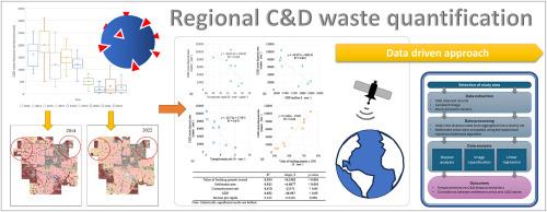
Abstract Image

利用卫星图像量化 COVID-19 期间的建筑和拆除废物处置行为
COVID-19 大流行扰乱了传统的城市固体废物 (MSW) 管理方法,影响了废物产生率。虽然对城市固体废物流进行了广泛的研究和报告,但对建筑和拆除(C&D)废物的影响仍被忽视。这项研究开发了一个创新的分析框架,利用卫星图像来量化加拿大一个中等城市在 COVID-19 限制期间的建筑和拆除废物处置率。通过对 Landsat-8 图像进行监督分类,得出 8.8 年内(2014-2022 年)的沉降区域。利用回归分析评估了 C&D 处置率与沉降区的关系。结果显示,与疫情发生前相比,2020 年的平均每周 C&D 处置量减少了 73.4%,这反映了建筑活动的减少。居住区面积与人均垃圾处理量呈很强的正相关性(R2 = 0.812),为影响垃圾处理量的城市化模式提供了空间证据。在所考察的社会经济因素中,建筑许可证的发放价值对垃圾和废弃物数量的影响最大(R2 = 0.934)。在大流行病期间现场审计受到限制时,基于卫星图像的方法可间接估算中断的 C&D 废物流。该框架为市政当局提供了空间决策支持,以制定数据驱动的 C&D 废物管理政策,这些政策对于智能城市和应对未来的公共卫生突发事件至关重要。
本文章由计算机程序翻译,如有差异,请以英文原文为准。
求助全文
约1分钟内获得全文 求助全文
来源期刊
Environmental and Sustainability Indicators
Environmental and Sustainability Indicators Environmental Science-Environmental Science (miscellaneous)
CiteScore
7.80
自引率
2.30%
发文量
49
审稿时长
57 days
×
引用
GB/T 7714-2015
复制
MLA
复制
APA
复制
导出至
BibTeX EndNote RefMan NoteFirst NoteExpress
×
提示
您的信息不完整,为了账户安全,请先补充。
现在去补充
×
提示
您因"违规操作"
具体请查看互助需知
我知道了
×
提示
确定
请完成安全验证×
copy
已复制链接
快去分享给好友吧!
我知道了
右上角分享
点击右上角分享
0
联系我们:info@booksci.cn Book学术提供免费学术资源搜索服务,方便国内外学者检索中英文文献。致力于提供最便捷和优质的服务体验。 Copyright © 2023 布克学术 All rights reserved.
京ICP备2023020795号-1
ghs 京公网安备 11010802042870号
Book学术文献互助
Book学术文献互助群
群 号:481959085
Book学术官方微信