3-D P-wave velocity structure of the upper mantle beneath eastern Indonesia from body wave tomography
IF 1.9
3区 地球科学
Q2 GEOCHEMISTRY & GEOPHYSICS
引用次数: 0
Abstract
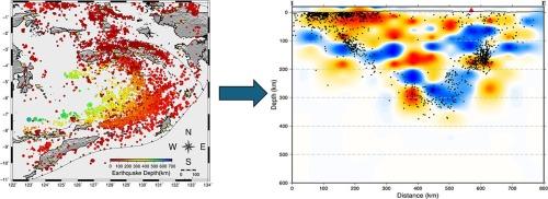
Eastern Indonesia's tectonic setting is well known for its complexity and intense seismic activity. Controlled by several major and minor plates, including the Eurasian, Australian, and Pacific plates, this region is famous for its U-shaped subduction system beneath the Banda Arc. To better understand the architecture of the underlying structure in this region, we performed body-wave travel time tomography using ten years of catalog data provided by the Indonesian Agency for Meteorology, Climatology, and Geophysics. We utilize 9729 events in total, from which 46,446 P-wave arrival times were extracted. We used a double difference method to relocate the initial event catalog, which produced a pattern of seismicity consistent with a curved subduction system. Our tomographic model reveals a high velocity band between 90 and 240 km depth in the upper mantle, which is interpreted to be a concave dipping lithospheric slab that is parallel to the present-day Banda arc. Our results also show that lithosphere subducting from the north and south starts to collide at a depth of 300–350 km and becomes shallower further east. Apparent discontinuities in the high velocity band and a corresponding lack of seismicity supports the presence of a slab tear to the west of Seram. A dipping high velocity structure that is present from south to north beneath the island of Timor represents a subducting slab that dips more steeply beyond a depth of 150–200 km, which appears consistent with slab roll-back. Our tomographic model also shows evidence of back arc thrusting to the north of Sumbawa and Flores Islands in the form of a south-dipping higher velocity band at shallow depth. Furthermore, our tomographic models also reveal the possible presence of underthrust continental forearc in the form of a thin higher velocity anomaly that connects the backarc thrust and northward dipping lithosphere slab in the Timor area. Finally, a zone of low velocity above the higher velocity slab is clearly seen beneath Seram Island at a depth of ∼100 km and may represent a partial melting zone.
通过体波层析成像研究印度尼西亚东部地下上地幔的三维 P 波速度结构
印度尼西亚东部的构造环境以其复杂性和强烈的地震活动而闻名。该地区受欧亚板块、澳大利亚板块和太平洋板块等几大板块和次板块的控制,以班达弧下的 U 型俯冲系统而闻名。为了更好地了解该地区的底层结构,我们利用印度尼西亚气象、气候和地球物理局提供的十年目录数据进行了体波走时层析成像。我们总共利用了 9729 个事件,从中提取了 46446 个 P 波到达时间。我们使用双差分法重新定位初始事件目录,从而得出与弯曲俯冲系统相一致的地震模式。我们的层析成像模型揭示了上地幔 90 至 240 千米深处的高速带,该高速带被解释为与现今班达弧平行的凹倾岩石圈板块。我们的研究结果还表明,从北面和南面俯冲而来的岩石圈在 300-350 千米深处开始碰撞,越往东越浅。高速带的明显不连续性和相应的地震活动的缺失,支持了塞拉姆以西板块撕裂的存在。帝汶岛下方自南向北存在一个倾斜的高速结构,它代表了俯冲板块,在深度超过 150-200 千米后,倾斜度更大,这似乎与板块回滚一致。我们的层析成像模型还显示,在松巴哇岛和弗洛勒斯岛以北,有背弧推力的迹象,其形式是在浅层有一个向南倾斜的较高速度带。此外,我们的层析成像模型还揭示了可能存在的大陆前弧下推,其形式为一条较细的高速异常带,连接着帝汶地区的后弧推力和北倾岩石圈板块。最后,在塞拉姆岛下方 100 千米深处,可以清楚地看到高速板块上方的低速区,可能代表部分熔化区。
本文章由计算机程序翻译,如有差异,请以英文原文为准。
求助全文
约1分钟内获得全文
求助全文
来源期刊

Physics of the Earth and Planetary Interiors
地学天文-地球化学与地球物理
CiteScore
5.00
自引率
4.30%
发文量
78
审稿时长
18.5 weeks
期刊介绍:
Launched in 1968 to fill the need for an international journal in the field of planetary physics, geodesy and geophysics, Physics of the Earth and Planetary Interiors has now grown to become important reading matter for all geophysicists. It is the only journal to be entirely devoted to the physical and chemical processes of planetary interiors.
Original research papers, review articles, short communications and book reviews are all published on a regular basis; and from time to time special issues of the journal are devoted to the publication of the proceedings of symposia and congresses which the editors feel will be of particular interest to the reader.
 求助内容:
求助内容: 应助结果提醒方式:


