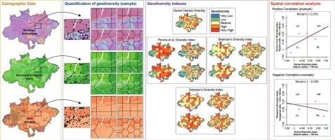
Evaluation of geodiversity in the Brazilian Amazon using different quantification methodologies
IF 3.1
2区 地球科学
Q2 GEOGRAPHY, PHYSICAL
引用次数: 0
Abstract
When one considers geodiversity as the variability of abiotic elements distributed on the earth's surface in an unequal and complex manner, and that the configuration of these elements plays an important role in ecosystem dynamics, it becomes necessary and important to evaluate the different forms by which its spatial organization can be quantified and mapped. A recent academic effort in different countries, scales, and territories aims to evaluate and quantify geodiversity and its spatial variation. Thus, this work aims to apply and compare the spatial distribution of the geodiversity indices derived from four methodologies in the Brazilian Amazon. From this analysis, we seek to understand the distribution of the geodiversity indices in the Brazilian Amazon and organize a cartographic base for future correlations with spatial data representative of biodiversity and human appropriation of the territory. When one considers the tendencies of spatial similarity for each methodology, regardless of the size and shape of the quantification cells, the indices generated with the second methodology have a higher correlation with the basic index. In general, since they consider the same diversity measure (richness), the tendencies of direct spatial similarity are highlighted by the basic index and the products of the second methodology. The Shannon's index in the 250 × 250 km hexagonal grids, besides the high value of positive correlation, is also equivalent to the basic index, regaining the spatial proportion of each class, above all other indices. The indices generated from Shannon's and Simpson's indices tend to differ from the other indices because, besides class richness, they also measure evenness. The comparison between the quantitative indices shows some tendencies in the spatial patterns of geodiversity of the Brazilian Amazon but also presents indications of the limitations imposed by the different measurement criteria of the abiotic variables used.

使用不同的量化方法评估巴西亚马逊地区的地质多样性
当我们认为地质多样性是以不平等和复杂的方式分布在地球表面的非生物元素的变异性,并且这些元素的配置在生态系统动态中发挥着重要作用时,对其空间组织进行量化和绘图的不同形式进行评估就变得非常必要和重要。最近,不同国家、不同规模和不同地区的学术界都在努力评估和量化地质多样性及其空间变化。因此,这项工作旨在应用和比较巴西亚马逊地区由四种方法得出的地质多样性指数的空间分布情况。通过分析,我们试图了解巴西亚马逊地区的地质多样性指数分布情况,并为今后与代表生物多样性和人类对该地区的占用的空间数据相关联建立一个制图基础。如果考虑到每种方法的空间相似性趋势,无论量化单元的大小和形状如何,第二种方法生成的指数与基本指数的相关性更高。一般来说,由于它们考虑的是相同的多样性度量(丰富度),基本指数和第二种方法的产品都突出了直接空间相似性的趋势。在 250 × 250 千米的六边形网格中,香农指数除了具有较高的正相关值外,还与基本指数相当,重新获得了每一类的空间比例,高于所有其他指数。由香农指数和辛普森指数生成的指数往往与其他指数不同,因为除了类别丰富度外,它们还测量均匀度。定量指数之间的比较显示了巴西亚马逊地区地质多样性空间模式的一些趋势,但也表明了所使用的非生物变量的不同测量标准所带来的局限性。
本文章由计算机程序翻译,如有差异,请以英文原文为准。
求助全文
约1分钟内获得全文
求助全文
来源期刊

Geomorphology
地学-地球科学综合
CiteScore
8.00
自引率
10.30%
发文量
309
审稿时长
3.4 months
期刊介绍:
Our journal''s scope includes geomorphic themes of: tectonics and regional structure; glacial processes and landforms; fluvial sequences, Quaternary environmental change and dating; fluvial processes and landforms; mass movement, slopes and periglacial processes; hillslopes and soil erosion; weathering, karst and soils; aeolian processes and landforms, coastal dunes and arid environments; coastal and marine processes, estuaries and lakes; modelling, theoretical and quantitative geomorphology; DEM, GIS and remote sensing methods and applications; hazards, applied and planetary geomorphology; and volcanics.
 求助内容:
求助内容: 应助结果提醒方式:


