Giant landslide, hidden caldera structure, magnetic anomalies and tectonics in southern Tyrrhenian Sea (Italy)
IF 3.1
2区 地球科学
Q2 GEOGRAPHY, PHYSICAL
引用次数: 0
Abstract
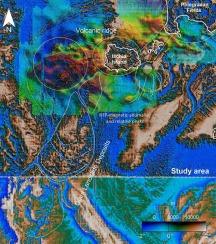
Phlegraean Fields and Ischia Island are large, densely populated, active volcanic structures located in the Campanian Tyrrhenian margin between the onshore and offshore sectors. While the emerged landforms provide significant insights into a series of intense volcano-tectonic events of the last 60 ka, our understanding of the sub-marine portion of these volcanoes remains limited due to its inaccessibility to direct exploration. In the last decades, the use of magnetic methods has proven to be useful in volcanic context, given the presence of large magnetization contrasts, whereas the implementation of a high-resolution Digital Elevation Model (DEM) has allowed the integration of detailed morphological analyses into the geophysical studies. In this work, we present two new high-resolution airborne and shipborne magnetic surveys, carried out by the National Institute of Geophysics and Volcanology (INGV) in the marine sector of the Phlegraean Fields caldera (Pozzuoli Bay) and surrounding sea sectors. Moreover, the new datasets have been integrated with older marine surveys carried out by the National Research Council (CNR) to extend the resulting magnetic anomaly map embracing the whole Campanian offshore volcanic structures, excluding Ischia Island. As a result, we present here three new magnetic anomaly maps used for an integrated interpretation of magnetic, morphological, and tectonic features. The study results provide valuable insights into the relationship between volcanic, magmatic, and tectonic activity, which may be useful for further investigations. Among the most notable findings are: the identification of the magnetic signatures of regional faults, previously unknown caldera structures, and a massive rock avalanche. Consequently, our research provides a significant contribution to seabed exploration aimed at identifying potential hazard factors in the study area.
意大利第勒尼安海南部的巨型滑坡、隐藏的火山口结构、磁异常和构造作用
菲勒格拉埃火山区和伊斯基亚岛是位于坎帕尼亚-第勒尼安海边缘的大型、人口稠密的活火山结构,处于陆地和近海区域之间。虽然新出现的地貌为了解过去 60 ka 年间一系列强烈的火山构造事件提供了重要信息,但由于无法直接勘探,我们对这些火山的海底部分的了解仍然有限。在过去的几十年中,由于存在较大的磁化对比,磁力方法的使用已被证明在火山环境中非常有用,而高分辨率数字高程模型(DEM)的实施则使详细的形态分析得以融入地球物理研究中。在这项工作中,我们介绍了国家地球物理和火山学研究所(INGV)在菲格拉耶火山口海洋区(波祖利湾)和周边海区进行的两次新的高分辨率机载和船载磁力勘测。此外,新数据集还与国家研究委员会(CNR)开展的旧海洋勘测相结合,以扩展所绘制的磁异常图,使其涵盖整个坎帕尼亚近海火山结构,但不包括伊斯基亚岛。因此,我们在此展示了三幅新的磁异常图,用于综合解释磁性、形态和构造特征。研究结果为火山、岩浆和构造活动之间的关系提供了有价值的见解,可能有助于进一步的研究。其中最显著的发现包括:确定了区域断层的磁性特征、以前未知的火山口结构以及大规模岩崩。因此,我们的研究为旨在确定研究区域潜在危险因素的海底勘探做出了重大贡献。
本文章由计算机程序翻译,如有差异,请以英文原文为准。
求助全文
约1分钟内获得全文
求助全文
来源期刊

Geomorphology
地学-地球科学综合
CiteScore
8.00
自引率
10.30%
发文量
309
审稿时长
3.4 months
期刊介绍:
Our journal''s scope includes geomorphic themes of: tectonics and regional structure; glacial processes and landforms; fluvial sequences, Quaternary environmental change and dating; fluvial processes and landforms; mass movement, slopes and periglacial processes; hillslopes and soil erosion; weathering, karst and soils; aeolian processes and landforms, coastal dunes and arid environments; coastal and marine processes, estuaries and lakes; modelling, theoretical and quantitative geomorphology; DEM, GIS and remote sensing methods and applications; hazards, applied and planetary geomorphology; and volcanics.
 求助内容:
求助内容: 应助结果提醒方式:


