Exploring soil pollution patterns in Ghana's northeastern mining zone using machine learning models

IF 5.4 Q2 ENGINEERING, ENVIRONMENTAL
Daniel Kwayisi , Raymond Webrah Kazapoe , Seidu Alidu , Samuel Dzidefo Sagoe , Aliyu Ohiani Umaru , Ebenezer Ebo Yahans Amuah , Prosper Kpiebaya
{"title":"Exploring soil pollution patterns in Ghana's northeastern mining zone using machine learning models","authors":"Daniel Kwayisi ,&nbsp;Raymond Webrah Kazapoe ,&nbsp;Seidu Alidu ,&nbsp;Samuel Dzidefo Sagoe ,&nbsp;Aliyu Ohiani Umaru ,&nbsp;Ebenezer Ebo Yahans Amuah ,&nbsp;Prosper Kpiebaya","doi":"10.1016/j.hazadv.2024.100480","DOIUrl":null,"url":null,"abstract":"<div><div>This study assessed the pollution status and effectiveness of machine learning models in predicting pollution indices in soils from a mining area in Northeastern Ghana. 552 soil samples were analysed with an Energy Dispersive X-ray Fluorescence (ED-XRF) spectrometer for their elemental concentrations. Four pollution indices; Nemerow Integrated Pollution Index (NIPI), degree of contamination (Cdeg), modified degree of contamination (mCdeg) and Pollution Load Index (PLI). Additionally, the Multivariate Adaptive Regression Splines (MARS) machine learning approach were used. The high CV%, skewness, and kurtosis values show a high degree of variability and uneven distribution patterns which denotes dispersed hotspots that can be interpreted as an influence of gold anomalies and illegal mining activities in the area. V (120.86 mg/L), Cr (242.42 mg/L), Co (30.92 mg/L) Ba (337.62 mg/L), and Zn (35.42 mg/L) recorded values higher than the global and regional contaminant thresholds. The NIPI shows that 46.74% and 26.81% of samples are slightly and moderately polluted respectively. The Cdeg analysis supports these findings, with 36.96% and 41.49% of samples classified as having “moderate” to “considerable” contamination, respectively. The PLI indicates progressive soil quality deterioration (43.84%) of samples reflecting substantial environmental disturbance. The pollution indices show the effect of illegal mining on Shaega, Buin and other areas in the eastern boundary of the study. The MARS models developed for the study demonstrated high predictive capabilities with an <span><math><msup><mrow><mi>R</mi></mrow><mn>2</mn></msup></math></span> value of 0.9665 for model 1 (NIPI), and RMSE and MAE values of 0.8227 and 0.4287 respectively. For model 2 (Cdeg), <span><math><msup><mrow><mi>R</mi></mrow><mn>2</mn></msup></math></span> value of 0.9863, RMSE and MAE of 1.0416 and 0.6181, respectively. Model 3 (mCdeg) produced an <span><math><msup><mrow><mi>R</mi></mrow><mn>2</mn></msup></math></span> value of 0.9844, RMSE and MAE of 0.1225 and 0.0670. These findings suggest MARS models can be an integral tool for soil quality analysis in cooperation with pollution indices. The study suggests that remedial and legislative measures be implemented to address the issue of illegal mining in the area.</div></div>","PeriodicalId":73763,"journal":{"name":"Journal of hazardous materials advances","volume":"16 ","pages":"Article 100480"},"PeriodicalIF":5.4000,"publicationDate":"2024-09-22","publicationTypes":"Journal Article","fieldsOfStudy":null,"isOpenAccess":false,"openAccessPdf":"","citationCount":"0","resultStr":null,"platform":"Semanticscholar","paperid":null,"PeriodicalName":"Journal of hazardous materials advances","FirstCategoryId":"1085","ListUrlMain":"https://www.sciencedirect.com/science/article/pii/S2772416624000810","RegionNum":0,"RegionCategory":null,"ArticlePicture":[],"TitleCN":null,"AbstractTextCN":null,"PMCID":null,"EPubDate":"","PubModel":"","JCR":"Q2","JCRName":"ENGINEERING, ENVIRONMENTAL","Score":null,"Total":0}
引用次数: 0

Abstract

This study assessed the pollution status and effectiveness of machine learning models in predicting pollution indices in soils from a mining area in Northeastern Ghana. 552 soil samples were analysed with an Energy Dispersive X-ray Fluorescence (ED-XRF) spectrometer for their elemental concentrations. Four pollution indices; Nemerow Integrated Pollution Index (NIPI), degree of contamination (Cdeg), modified degree of contamination (mCdeg) and Pollution Load Index (PLI). Additionally, the Multivariate Adaptive Regression Splines (MARS) machine learning approach were used. The high CV%, skewness, and kurtosis values show a high degree of variability and uneven distribution patterns which denotes dispersed hotspots that can be interpreted as an influence of gold anomalies and illegal mining activities in the area. V (120.86 mg/L), Cr (242.42 mg/L), Co (30.92 mg/L) Ba (337.62 mg/L), and Zn (35.42 mg/L) recorded values higher than the global and regional contaminant thresholds. The NIPI shows that 46.74% and 26.81% of samples are slightly and moderately polluted respectively. The Cdeg analysis supports these findings, with 36.96% and 41.49% of samples classified as having “moderate” to “considerable” contamination, respectively. The PLI indicates progressive soil quality deterioration (43.84%) of samples reflecting substantial environmental disturbance. The pollution indices show the effect of illegal mining on Shaega, Buin and other areas in the eastern boundary of the study. The MARS models developed for the study demonstrated high predictive capabilities with an R2 value of 0.9665 for model 1 (NIPI), and RMSE and MAE values of 0.8227 and 0.4287 respectively. For model 2 (Cdeg), R2 value of 0.9863, RMSE and MAE of 1.0416 and 0.6181, respectively. Model 3 (mCdeg) produced an R2 value of 0.9844, RMSE and MAE of 0.1225 and 0.0670. These findings suggest MARS models can be an integral tool for soil quality analysis in cooperation with pollution indices. The study suggests that remedial and legislative measures be implemented to address the issue of illegal mining in the area.
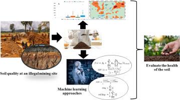
Abstract Image

利用机器学习模型探索加纳东北部矿区的土壤污染模式
本研究评估了加纳东北部矿区土壤的污染状况以及机器学习模型预测污染指数的有效性。使用能量色散 X 射线荧光 (ED-XRF) 光谱仪分析了 552 个土壤样本的元素浓度。四个污染指数:内梅罗综合污染指数 (NIPI)、污染程度 (Cdeg)、修正污染程度 (mCdeg) 和污染负荷指数 (PLI)。此外,还使用了多变量自适应回归样条曲线(MARS)机器学习方法。高 CV%、偏斜度和峰度值显示了高度的变异性和不均匀的分布模式,这表明存在分散的热点,可以解释为该地区金矿异常和非法采矿活动的影响。钒(120.86 毫克/升)、铬(242.42 毫克/升)、钴(30.92 毫克/升)、钡(337.62 毫克/升)和锌(35.42 毫克/升)的数值高于全球和区域污染物阈值。国家污染指数显示,分别有 46.74% 和 26.81% 的样本受到轻度和中度污染。Cdeg 分析也支持这些结果,分别有 36.96% 和 41.49% 的样本被归类为 "中度 "至 "严重 "污染。PLI 显示,43.84% 的样本土壤质量逐渐恶化,反映出环境受到严重干扰。污染指数显示了非法采矿对 Shaega、Buin 和研究东部边界其他地区的影响。为该研究开发的 MARS 模型具有很高的预测能力,模型 1(NIPI)的 R2 值为 0.9665,RMSE 和 MAE 值分别为 0.8227 和 0.4287。模型 2(Cdeg)的 R2 值为 0.9863,RMSE 和 MAE 分别为 1.0416 和 0.6181。模型 3(mCdeg)的 R2 值为 0.9844,RMSE 和 MAE 分别为 0.1225 和 0.0670。这些研究结果表明,MARS 模型可以与污染指数合作,成为土壤质量分析的一个不可或缺的工具。研究建议采取补救和立法措施来解决该地区的非法采矿问题。
本文章由计算机程序翻译,如有差异,请以英文原文为准。
求助全文
约1分钟内获得全文 求助全文
来源期刊
Journal of hazardous materials advances
Journal of hazardous materials advances Environmental Engineering
CiteScore
4.80
自引率
0.00%
发文量
0
审稿时长
50 days
×
引用
GB/T 7714-2015
复制
MLA
复制
APA
复制
导出至
BibTeX EndNote RefMan NoteFirst NoteExpress
×
提示
您的信息不完整,为了账户安全,请先补充。
现在去补充
×
提示
您因"违规操作"
具体请查看互助需知
我知道了
×
提示
确定
请完成安全验证×
copy
已复制链接
快去分享给好友吧!
我知道了
右上角分享
点击右上角分享
0
联系我们:info@booksci.cn Book学术提供免费学术资源搜索服务,方便国内外学者检索中英文文献。致力于提供最便捷和优质的服务体验。 Copyright © 2023 布克学术 All rights reserved.
京ICP备2023020795号-1
ghs 京公网安备 11010802042870号
Book学术文献互助
Book学术文献互助群
群 号:481959085
Book学术官方微信