Synthesis of drainage characteristics, water resources and sediment supply of the Bengal basin

IF 2.9 Q2 GEOGRAPHY, PHYSICAL
Md Bazlar Rashid , Md Ahosan Habib , Md Sultan-Ul-Islam , Rahat Khan , Abu Reza Md Towfiqul Islam
{"title":"Synthesis of drainage characteristics, water resources and sediment supply of the Bengal basin","authors":"Md Bazlar Rashid ,&nbsp;Md Ahosan Habib ,&nbsp;Md Sultan-Ul-Islam ,&nbsp;Rahat Khan ,&nbsp;Abu Reza Md Towfiqul Islam","doi":"10.1016/j.qsa.2024.100244","DOIUrl":null,"url":null,"abstract":"<div><div>This systematic review attempts to delineate a synthesis of the main drainage characteristics of the Bengal basin through the study of historical data, old maps, reports, records, satellite images, water and sediment discharge, etc. In doing so, especial emphasize is given on the changing scenery of the river courses (paleo-present), sediment supply and water resources as well as downstream impact on socio-economy and valuable landforms (e.g., agricultural, settlement, urban, sub-urban, municipality, industry, forest, etc.). Nevertheless, impacts on biodiversity, ecosystem, water discharge and suspended sediment transport to deltas, eco-environment, human-life etcetera were also considered in evaluating the drainage characteristics. With continuing earlier custom, till now, human lives, valuable landforms and national economy have continuously been negatively affected by the rapid and frequently changing flow path of the largest rivers (Padma, Jamuna, Meghna) with the consequential river bank erosion. Furthermore, the polders, embankments, river training, and upstream barrages/dams lead to cause and enhance undesired channel siltation, land subsidence, severe erosion, sudden catastrophic floods, water logging, salinity, etc., and also hinder sediment transportation/delivery and water discharge to the basin. Finally, it has a huge impact on the basin's human-life, landforms, biodiversity, ecosystem, eco-environment, etc.</div></div>","PeriodicalId":34142,"journal":{"name":"Quaternary Science Advances","volume":"16 ","pages":"Article 100244"},"PeriodicalIF":2.9000,"publicationDate":"2024-09-26","publicationTypes":"Journal Article","fieldsOfStudy":null,"isOpenAccess":false,"openAccessPdf":"","citationCount":"0","resultStr":null,"platform":"Semanticscholar","paperid":null,"PeriodicalName":"Quaternary Science Advances","FirstCategoryId":"1085","ListUrlMain":"https://www.sciencedirect.com/science/article/pii/S2666033424000820","RegionNum":0,"RegionCategory":null,"ArticlePicture":[],"TitleCN":null,"AbstractTextCN":null,"PMCID":null,"EPubDate":"","PubModel":"","JCR":"Q2","JCRName":"GEOGRAPHY, PHYSICAL","Score":null,"Total":0}
引用次数: 0

Abstract

This systematic review attempts to delineate a synthesis of the main drainage characteristics of the Bengal basin through the study of historical data, old maps, reports, records, satellite images, water and sediment discharge, etc. In doing so, especial emphasize is given on the changing scenery of the river courses (paleo-present), sediment supply and water resources as well as downstream impact on socio-economy and valuable landforms (e.g., agricultural, settlement, urban, sub-urban, municipality, industry, forest, etc.). Nevertheless, impacts on biodiversity, ecosystem, water discharge and suspended sediment transport to deltas, eco-environment, human-life etcetera were also considered in evaluating the drainage characteristics. With continuing earlier custom, till now, human lives, valuable landforms and national economy have continuously been negatively affected by the rapid and frequently changing flow path of the largest rivers (Padma, Jamuna, Meghna) with the consequential river bank erosion. Furthermore, the polders, embankments, river training, and upstream barrages/dams lead to cause and enhance undesired channel siltation, land subsidence, severe erosion, sudden catastrophic floods, water logging, salinity, etc., and also hinder sediment transportation/delivery and water discharge to the basin. Finally, it has a huge impact on the basin's human-life, landforms, biodiversity, ecosystem, eco-environment, etc.
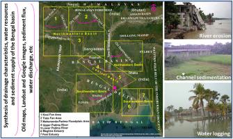
Abstract Image

孟加拉盆地的排水特征、水资源和泥沙供应综述
本系统综述试图通过研究历史数据、古地图、报告、记录、卫星图像、水和沉积物排放量等,对孟加拉盆地的主要排水特征进行综合描述。在此过程中,特别强调了河道(古至今)、沉积物供应和水资源的变化情况,以及下游对社会经济和有价值的地貌(如农业、定居点、城市、城郊、市政、工业、森林等)的影响。不过,在评估排水特征时,也考虑了对生物多样性、生态系统、排水和三角洲悬浮沉积物迁移、生态环境、人类生活等方面的影响。由于延续了之前的习惯,迄今为止,最大的河流(帕德玛河、贾木纳河、梅格纳河)湍急而频繁的流向变化以及随之而来的河岸侵蚀不断对人类生活、宝贵的地貌和国民经济造成负面影响。此外,圩田、堤坝、河道整治和上游拦河坝/坝导致并加剧了河道淤积、土地沉降、严重侵蚀、突发灾难性洪水、水涝、盐碱化等问题,同时也阻碍了沉积物的运输/输送以及向流域的排水。最后,还会对流域的人类生活、地貌、生物多样性、生态系统、生态环境等产生巨大影响。
本文章由计算机程序翻译,如有差异,请以英文原文为准。
求助全文
约1分钟内获得全文 求助全文
来源期刊
Quaternary Science Advances
Quaternary Science Advances Earth and Planetary Sciences-Earth-Surface Processes
CiteScore
4.00
自引率
13.30%
发文量
16
审稿时长
61 days
×
引用
GB/T 7714-2015
复制
MLA
复制
APA
复制
导出至
BibTeX EndNote RefMan NoteFirst NoteExpress
×
提示
您的信息不完整,为了账户安全,请先补充。
现在去补充
×
提示
您因"违规操作"
具体请查看互助需知
我知道了
×
提示
确定
请完成安全验证×
copy
已复制链接
快去分享给好友吧!
我知道了
右上角分享
点击右上角分享
0
联系我们:info@booksci.cn Book学术提供免费学术资源搜索服务,方便国内外学者检索中英文文献。致力于提供最便捷和优质的服务体验。 Copyright © 2023 布克学术 All rights reserved.
京ICP备2023020795号-1
ghs 京公网安备 11010802042870号
Book学术文献互助
Book学术文献互助群
群 号:481959085
Book学术官方微信