Integrating ecosystem services trade-off, drivers and zoning into watershed water environment management in Nansihu Lake Basin, China
IF 7
2区 环境科学与生态学
Q1 ENVIRONMENTAL SCIENCES
引用次数: 0
Abstract
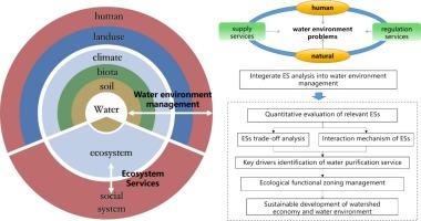
A series of ecosystem services (ESs) have a significant impact on water environment. How these ESs can be integrated into water environment management in the lens of coupled human and natural system (CHANS) is still lack exploration. This study proposes an integrating framework that connects the ESs with water environment management to facilitate the watershed sustainable development. We employ the InVEST model to evaluate typical ESs in the Nansihu Lake Basin (largest freshwater lake in Shandong, China), and analyze the spatiotemporal characteristics and trade-off of multiple ESs indicators. By revealing the interaction mechanism and key drivers of ESs and conducting ecological functional zoning, we investigate how ESs can facilitate water environment management in the Nansihu Lake Basin. The results indicated that: (1) The high-value areas of agricultural supply service are mainly distributed in the western plain area of the basin, while high-value areas of water provision, water purification and soil conservation services are in the mountainous and hilly areas in the eastern part of the basin. (2) There is a significant trade-off between crop supply service and water purification services. Crop and livestock supply services have a greater effect on water purification services (TN) than other services. (3) Crop area sown, total power of agricultural machinery and fertilizer application are the main drivers of water purification services (TN). (4) The basin can be divided into three ecological function zones, the agricultural production zone, the ecological regulation zone and the ecological redline zone. These findings imply that water environment management should be integrated with ESs by strengthening intersectoral collaboration, conducting zoning management in watershed planning and applying differentiated control measures in each zone. This includes optimizing the scale and structure of agriculture, and implementing circular economy and clean production practices. This study explored a comprehensive framework of integrating ESs into water environment management to facilitate the sustainable development of watershed.

将生态系统服务权衡、驱动因素和分区纳入中国南四湖流域水环境管理
一系列生态系统服务(ES)对水环境有着重要影响。在人与自然耦合系统(CHANS)的视角下,如何将这些生态系统服务纳入水环境管理仍缺乏探索。本研究提出了一个整合框架,将生态系统服务与水环境管理联系起来,以促进流域的可持续发展。我们采用 InVEST 模型评估了南四湖流域(中国山东最大的淡水湖)的典型生态系统服务,分析了多个生态系统服务指标的时空特征和权衡。通过揭示ESs的相互作用机制和关键驱动因子,并进行生态功能区划,探讨ESs如何促进南四湖流域的水环境管理。结果表明(1)农业供给服务的高价值区主要分布在流域西部平原区,而供水、水净化和水土保持服务的高价值区则分布在流域东部山区和丘陵区。(2) 农作物供水服务与水净化服务之间存在明显的权衡。作物和牲畜供给服务对水净化服务(TN)的影响大于其他服务。(3) 作物播种面积、农业机械总动力和化肥施用量是水净化服务(TN)的主要驱动因素。(4) 流域可划分为三个生态功能区,即农业生产区、生态调节区和生态红线区。这些研究结果表明,水环境管理应与生态系统服务相结合,加强部门间合作,在流域规划中进行分区管理,并在各区采取有区别的控制措施。这包括优化农业规模和结构,实施循环经济和清洁生产。本研究探讨了将环境系统融入水环境管理的综合框架,以促进流域的可持续发展。
本文章由计算机程序翻译,如有差异,请以英文原文为准。
求助全文
约1分钟内获得全文
求助全文
来源期刊

Ecological Indicators
环境科学-环境科学
CiteScore
11.80
自引率
8.70%
发文量
1163
审稿时长
78 days
期刊介绍:
The ultimate aim of Ecological Indicators is to integrate the monitoring and assessment of ecological and environmental indicators with management practices. The journal provides a forum for the discussion of the applied scientific development and review of traditional indicator approaches as well as for theoretical, modelling and quantitative applications such as index development. Research into the following areas will be published.
• All aspects of ecological and environmental indicators and indices.
• New indicators, and new approaches and methods for indicator development, testing and use.
• Development and modelling of indices, e.g. application of indicator suites across multiple scales and resources.
• Analysis and research of resource, system- and scale-specific indicators.
• Methods for integration of social and other valuation metrics for the production of scientifically rigorous and politically-relevant assessments using indicator-based monitoring and assessment programs.
• How research indicators can be transformed into direct application for management purposes.
• Broader assessment objectives and methods, e.g. biodiversity, biological integrity, and sustainability, through the use of indicators.
• Resource-specific indicators such as landscape, agroecosystems, forests, wetlands, etc.
 求助内容:
求助内容: 应助结果提醒方式:


