Forest catchment structure mediates shallow subsurface flow and soil base cation fluxes

IF 5.6 1区 农林科学 Q1 SOIL SCIENCE
Amanda Pennino , Brian D. Strahm , Kevin J. McGuire , Jennifer A. Bower , Scott W. Bailey , Madeline E. Schreiber , Donald S. Ross , Stephanie A. Duston , Joshua R. Benton
{"title":"Forest catchment structure mediates shallow subsurface flow and soil base cation fluxes","authors":"Amanda Pennino ,&nbsp;Brian D. Strahm ,&nbsp;Kevin J. McGuire ,&nbsp;Jennifer A. Bower ,&nbsp;Scott W. Bailey ,&nbsp;Madeline E. Schreiber ,&nbsp;Donald S. Ross ,&nbsp;Stephanie A. Duston ,&nbsp;Joshua R. Benton","doi":"10.1016/j.geoderma.2024.117045","DOIUrl":null,"url":null,"abstract":"<div><div>Hydrologic behavior and soil properties across forested landscapes with complex topography exhibit high variability. The interaction of groundwater with spatially distinct soils produces and transports solutes across catchments, however, the spatiotemporal relationships between groundwater dynamics and soil solute fluxes are difficult to directly evaluate. While whole-catchment export of solutes by shallow subsurface flow represents an integration of soil environments and conditions but many studies compartmentalize soil solute fluxes as hillslope vs. riparian, deep vs. shallow, or as individual soil horizon contributions. This potentially obscures and underestimates the hillslope variation and magnitude of solute fluxes and soil development across the landscape. This study determined the spatial variation and of shallow soil base cation fluxes associated with weathering reactions (Ca, Mg, and Na), soil elemental depletion, and soil saturation dynamics in upland soils within a small, forested watershed at the Hubbard Brook Experimental Forest, NH. Base cation fluxes were calculated using a combination of ion-exchange resins placed in shallow groundwater wells (0.3 – 1 m depth) located across hillslope transects (ridges to lower backslopes) and measurements of groundwater levels. Groundwater levels were also used to create metrics of annual soil saturation. Base cation fluxes were positively correlated with soil saturation frequency and were greatest in soil profiles where primary minerals were most depleted of base cations (i.e., highly weathered). Spatial differences in soil saturation across the catchment were strongly related to topographic properties of the upslope drainage area and are interpreted to result from spatial variations in transient groundwater dynamics. Results from this work suggest that the structure of a catchment defines the spatial architecture of base cation fluxes, likely reflecting the mediation of subsurface stormflow dynamics on soil development. Furthermore, this work highlights the importance of further compartmentalizing solute fluxes along hillslopes, where certain areas may disproportionately contribute solutes to the whole catchment. Refining catchment controls on base cation generation and transport could be an important tool for opening the black box of catchment elemental cycling.</div></div>","PeriodicalId":12511,"journal":{"name":"Geoderma","volume":null,"pages":null},"PeriodicalIF":5.6000,"publicationDate":"2024-09-25","publicationTypes":"Journal Article","fieldsOfStudy":null,"isOpenAccess":false,"openAccessPdf":"","citationCount":"0","resultStr":null,"platform":"Semanticscholar","paperid":null,"PeriodicalName":"Geoderma","FirstCategoryId":"97","ListUrlMain":"https://www.sciencedirect.com/science/article/pii/S001670612400274X","RegionNum":1,"RegionCategory":"农林科学","ArticlePicture":[],"TitleCN":null,"AbstractTextCN":null,"PMCID":null,"EPubDate":"","PubModel":"","JCR":"Q1","JCRName":"SOIL SCIENCE","Score":null,"Total":0}
引用次数: 0

Abstract

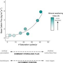
Hydrologic behavior and soil properties across forested landscapes with complex topography exhibit high variability. The interaction of groundwater with spatially distinct soils produces and transports solutes across catchments, however, the spatiotemporal relationships between groundwater dynamics and soil solute fluxes are difficult to directly evaluate. While whole-catchment export of solutes by shallow subsurface flow represents an integration of soil environments and conditions but many studies compartmentalize soil solute fluxes as hillslope vs. riparian, deep vs. shallow, or as individual soil horizon contributions. This potentially obscures and underestimates the hillslope variation and magnitude of solute fluxes and soil development across the landscape. This study determined the spatial variation and of shallow soil base cation fluxes associated with weathering reactions (Ca, Mg, and Na), soil elemental depletion, and soil saturation dynamics in upland soils within a small, forested watershed at the Hubbard Brook Experimental Forest, NH. Base cation fluxes were calculated using a combination of ion-exchange resins placed in shallow groundwater wells (0.3 – 1 m depth) located across hillslope transects (ridges to lower backslopes) and measurements of groundwater levels. Groundwater levels were also used to create metrics of annual soil saturation. Base cation fluxes were positively correlated with soil saturation frequency and were greatest in soil profiles where primary minerals were most depleted of base cations (i.e., highly weathered). Spatial differences in soil saturation across the catchment were strongly related to topographic properties of the upslope drainage area and are interpreted to result from spatial variations in transient groundwater dynamics. Results from this work suggest that the structure of a catchment defines the spatial architecture of base cation fluxes, likely reflecting the mediation of subsurface stormflow dynamics on soil development. Furthermore, this work highlights the importance of further compartmentalizing solute fluxes along hillslopes, where certain areas may disproportionately contribute solutes to the whole catchment. Refining catchment controls on base cation generation and transport could be an important tool for opening the black box of catchment elemental cycling.
Abstract Image

森林集水区结构对浅层地下水流和土壤基础阳离子通量的影响
地形复杂的森林景观的水文行为和土壤特性具有很大的变异性。地下水与空间上不同的土壤相互作用,在整个集水区产生并传输溶质,然而,地下水动态与土壤溶质通量之间的时空关系很难直接评估。虽然浅层地下水流对溶质的全流域输出代表了土壤环境和条件的整合,但许多研究将土壤溶质通量划分为山坡与河岸、深层与浅层,或单个土壤层的贡献。这可能会掩盖和低估整个地貌中山坡溶质通量和土壤发育的变化和规模。本研究确定了新罕布什尔州 Hubbard Brook 实验森林小森林流域内高地土壤中与风化反应(钙、镁和鈉)、土壤元素耗竭和土壤饱和动态相关的浅层土壤碱基阳离子通量的空间变化。基础阳离子通量是通过将离子交换树脂放置在位于山坡横断面(山脊到较低的背斜)的浅层地下水井(0.3 - 1 米深)中以及测量地下水位计算得出的。地下水位也被用来衡量年度土壤饱和度。基阳离子通量与土壤饱和频率呈正相关,在原生矿物质基阳离子耗竭最严重(即高度风化)的土壤剖面中,基阳离子通量最大。整个集水区土壤饱和度的空间差异与上坡排水区的地形特征密切相关,可解释为瞬时地下水动态空间变化的结果。这项工作的结果表明,集水区的结构决定了基础阳离子通量的空间结构,可能反映了地下暴雨流动态对土壤发育的影响。此外,这项研究还强调了沿山坡进一步划分溶质通量的重要性,因为某些区域可能对整个集水区的溶质贡献过大。完善集水区对基本阳离子生成和迁移的控制可能是打开集水区元素循环黑匣子的重要工具。
本文章由计算机程序翻译,如有差异,请以英文原文为准。
求助全文
约1分钟内获得全文 求助全文
来源期刊
Geoderma
Geoderma 农林科学-土壤科学
CiteScore
11.80
自引率
6.60%
发文量
597
审稿时长
58 days
期刊介绍: Geoderma - the global journal of soil science - welcomes authors, readers and soil research from all parts of the world, encourages worldwide soil studies, and embraces all aspects of soil science and its associated pedagogy. The journal particularly welcomes interdisciplinary work focusing on dynamic soil processes and functions across space and time.
×
引用
GB/T 7714-2015
复制
MLA
复制
APA
复制
导出至
BibTeX EndNote RefMan NoteFirst NoteExpress
×
提示
您的信息不完整,为了账户安全,请先补充。
现在去补充
×
提示
您因"违规操作"
具体请查看互助需知
我知道了
×
提示
确定
请完成安全验证×
copy
已复制链接
快去分享给好友吧!
我知道了
右上角分享
点击右上角分享
0
联系我们:info@booksci.cn Book学术提供免费学术资源搜索服务,方便国内外学者检索中英文文献。致力于提供最便捷和优质的服务体验。 Copyright © 2023 布克学术 All rights reserved.
京ICP备2023020795号-1
ghs 京公网安备 11010802042870号
Book学术文献互助
Book学术文献互助群
群 号:481959085
Book学术官方微信