Spatiotemporal evolution and driving mechanism of Dongting Lake based on 2005–2020 multi-source remote sensing data
IF 7.3
2区 环境科学与生态学
Q1 ECOLOGY
引用次数: 0
Abstract
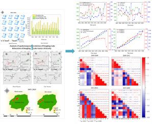
As one of the largest inland lakes in China, Dongting Lake has attracted widespread attention owing to its rich natural resources, unique geographical landscape, and important ecological functions. Recently, Dongting Lake has experienced phenomena such as an early dry season and backflow during the flood season. Multi-source remote sensing data and the normalised difference water index (NDWI) threshold method were used to systematically analyse the water area of the lake from 2005 to 2020. Additionally, it employed a centre of gravity migration model and a geographic detector model to investigate the lake's evolution patterns and driving mechanisms. The research identified notable fluctuations in Dongting Lake's water area during this period, with a particularly sharp decline in 2006—from 1509.74 km2 to 815 km2, marking a decrease of 694.74 km2 and a shrinkage rate of 46.01 %. Spatial analysis indicated that the centre of gravity of these water areas changed primarily between Nandashan Town, the Dongting Lake Management Committee, Wanzihu Township, and Qingtan Township, underscoring their significant influence on lake dynamics, including runoff, surface water availability, sediment deposition, and precipitation, all of which displayed strong positive correlations (Pearson coefficients of 0.57, 0.68, and 0.63, respectively), whereas population density showed a negative correlation (Pearson coefficient of −0.56). Furthermore, the study highlighted the substantial impact of the Digital Elevation Model (DEM) and its interaction with slope and aspect on Dongting Lake's evolution, with Q values of 0.537 and 0.543, respectively, emphasising their critical roles in shaping lake area changes and providing a crucial scientific basis for enhancing the understanding and effective management of water resources in the Dongting Lake Basin through comprehensive analysis of its spatiotemporal evolution and driving mechanisms.

基于 2005-2020 年多源遥感数据的洞庭湖时空演变及其驱动机制
作为中国最大的内陆湖泊之一,洞庭湖以其丰富的自然资源、独特的地理景观和重要的生态功能而受到广泛关注。近期,洞庭湖出现了枯水期提前、汛期倒灌等现象。本研究采用多源遥感数据和归一化差异水指数(NDWI)阈值法,对洞庭湖 2005 年至 2020 年的水域面积进行了系统分析。此外,研究还采用了重心迁移模型和地理探测器模型来研究湖泊的演变模式和驱动机制。研究发现,洞庭湖水域面积在此期间出现了明显的波动,尤其是2006年出现了急剧下降,从1509.74平方公里下降到815平方公里,减少了694.74平方公里,萎缩率达46.01%。空间分析表明,这些水域的重心主要在南大山镇、洞庭湖管委会、万紫湖乡和清潭乡之间发生变化,突出了它们对湖泊动态的重要影响,包括径流、地表水可利用性、泥沙沉积和降水,所有这些都显示出很强的正相关性(Pearson 系数分别为 0.57、0.68 和 0.63),而人口密度则显示出负相关(Pearson 系数为 -0.56)。此外,该研究还强调了数字高程模型(DEM)及其与坡度和坡向的相互作用对洞庭湖湖区演变的重要影响,Q 值分别为 0.537 和 0.543,强调了其在湖区变化中的关键作用,并通过对洞庭湖流域时空演变和驱动机制的综合分析,为加强对洞庭湖流域水资源的认识和有效管理提供了重要的科学依据。
本文章由计算机程序翻译,如有差异,请以英文原文为准。
求助全文
约1分钟内获得全文
求助全文
来源期刊

Ecological Informatics
环境科学-生态学
CiteScore
8.30
自引率
11.80%
发文量
346
审稿时长
46 days
期刊介绍:
The journal Ecological Informatics is devoted to the publication of high quality, peer-reviewed articles on all aspects of computational ecology, data science and biogeography. The scope of the journal takes into account the data-intensive nature of ecology, the growing capacity of information technology to access, harness and leverage complex data as well as the critical need for informing sustainable management in view of global environmental and climate change.
The nature of the journal is interdisciplinary at the crossover between ecology and informatics. It focuses on novel concepts and techniques for image- and genome-based monitoring and interpretation, sensor- and multimedia-based data acquisition, internet-based data archiving and sharing, data assimilation, modelling and prediction of ecological data.
 求助内容:
求助内容: 应助结果提醒方式:


