Groundwater potential mapping in arid and semi-arid regions of kurdistan region of Iraq: A geoinformatics-based machine learning approach
IF 4.9
Q2 ENGINEERING, ENVIRONMENTAL
引用次数: 0
Abstract
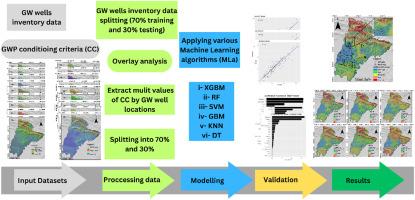
Groundwater (GW) is a crucial and increasingly scarce natural resource, that is affected by climate change and mismanagement. To manage GW resources effectively, it is crucial to accurately identify GW potential zones (GWPZs) using modern techniques. This study aimed to employ and assess geoinformatics-based machine learning (ML) models to delineate GWPZs in the Akre district, Kurdistan region of Iraq. Six nonparametric ML models were used: a support vector machine (SVM), k-nearest neighbours (KNN), decision tree (DT), random forest (RF), gradient boost DT (GBDT), and extreme gradient boosting (XGBoost). These models were trained on diverse GWPZ-favourable influencing factors, encompassing topographic, hydrological, geological, and environmental aspects. The findings of this study revealed that the XGBoost model outperformed the other nonparametric models in terms of best-fit performance and accuracy in generating a GW potential map (GWPM), achieving a R2 of 0.88, a root mean square error (RMSE) of 11.348, and a mean absolute error (MAE) of 6.623. Notably, over half of the study area (53%) was categorised as having high or very high GWPZs, primarily in the low-lying Rovia Plain. The study identified rainfall, elevation, lineament density (LD), drainage density (Dd), topographic wetness index (TWI), and slope as the most significant factors influencing GWPZ modelling. This study provides a comprehensive framework for GW resource management, ecological conservation, and urban development planning. These insights are crucial for stakeholders, policymakers, and local authorities in strategic resource planning and environmental stewardship.

伊拉克库尔德斯坦地区干旱和半干旱地区的地下水潜力绘图:基于地理信息学的机器学习方法
地下水(GW)是一种重要且日益稀缺的自然资源,受到气候变化和管理不善的影响。为有效管理地下水资源,利用现代技术准确识别地下水潜力区(GWPZ)至关重要。本研究旨在采用和评估基于地理信息学的机器学习(ML)模型,以划定伊拉克库尔德斯坦地区 Akre 区的全球水文潜势区。使用了六种非参数 ML 模型:支持向量机 (SVM)、k-近邻 (KNN)、决策树 (DT)、随机森林 (RF)、梯度提升 DT (GBDT) 和极端梯度提升 (XGBoost)。这些模型是根据不同的全球降水许可区有利影响因素进行训练的,包括地形、水文、地质和环境等方面。研究结果表明,XGBoost 模型在生成全球水文潜势图 (GWPM) 的最佳拟合性能和准确性方面优于其他非参数模型,R2 为 0.88,均方根误差 (RMSE) 为 11.348,平均绝对误差 (MAE) 为 6.623。值得注意的是,超过一半的研究区域(53%)被归类为高或极高全球降水分区,主要集中在低洼的罗维亚平原。研究发现,降雨、海拔、线状密度 (LD)、排水密度 (Dd)、地形湿润指数 (TWI) 和坡度是影响 GWPZ 模型的最重要因素。这项研究为全球降水资源管理、生态保护和城市发展规划提供了一个全面的框架。这些见解对于利益相关者、政策制定者和地方当局进行战略资源规划和环境管理至关重要。
本文章由计算机程序翻译,如有差异,请以英文原文为准。
求助全文
约1分钟内获得全文
求助全文
来源期刊

Groundwater for Sustainable Development
Social Sciences-Geography, Planning and Development
CiteScore
11.50
自引率
10.20%
发文量
152
期刊介绍:
Groundwater for Sustainable Development is directed to different stakeholders and professionals, including government and non-governmental organizations, international funding agencies, universities, public water institutions, public health and other public/private sector professionals, and other relevant institutions. It is aimed at professionals, academics and students in the fields of disciplines such as: groundwater and its connection to surface hydrology and environment, soil sciences, engineering, ecology, microbiology, atmospheric sciences, analytical chemistry, hydro-engineering, water technology, environmental ethics, economics, public health, policy, as well as social sciences, legal disciplines, or any other area connected with water issues. The objectives of this journal are to facilitate: • The improvement of effective and sustainable management of water resources across the globe. • The improvement of human access to groundwater resources in adequate quantity and good quality. • The meeting of the increasing demand for drinking and irrigation water needed for food security to contribute to a social and economically sound human development. • The creation of a global inter- and multidisciplinary platform and forum to improve our understanding of groundwater resources and to advocate their effective and sustainable management and protection against contamination. • Interdisciplinary information exchange and to stimulate scientific research in the fields of groundwater related sciences and social and health sciences required to achieve the United Nations Millennium Development Goals for sustainable development.
 求助内容:
求助内容: 应助结果提醒方式:


