The occurrence, mechanisms and hazards of large landslides along tablelands

Tomáš Pánek, Kristian Svennevig, Michal Břežný, Piotr Migoń
{"title":"The occurrence, mechanisms and hazards of large landslides along tablelands","authors":"Tomáš Pánek, Kristian Svennevig, Michal Břežný, Piotr Migoń","doi":"10.1038/s43017-024-00587-1","DOIUrl":null,"url":null,"abstract":"The largest terrestrial coalescent landslide areas of the Earth, spanning hundreds to thousands of square kilometres, occur along the fringes of relatively low-relief sedimentary and volcanic tablelands. However, difficulties in landslide recognition in these areas have led to underestimations of their frequency and likelihood. In this Review, we explore the global distribution, controls and dynamics of landslides occurring along tableland fringes. Landslide fringes are caused by the uninterrupted and extensive presence of weak sub-caprock lithologies below a more competent caprock. Topography, escarpment height and caprock thickness do not affect landslide size but can locally influence the type of displacement. Rotational landslides dominate most landslide fringes and will eventually lead to tableland consumption over million-year timescales. Some tableland rims can generate catastrophic long-runout rock avalanches or earthflows, which might in turn trigger tsunamis, river avulsion or outburst floods. Tablelands can also fail by slow (centimetre per year) landslide movements sufficient to cause damage to infrastructure. These hazards are increasing especially in high-latitude tablelands owing to cryosphere degradation, as observed in Western Greenland. A more detailed global inventory of landslide fringe activity is urgently needed to better quantify these potential hazards. The fringes of extensive flat-topped sedimentary or volcanic plateaus, called tablelands, host the largest coalescent landslide areas of the Earth. This Review highlights the factors contributing to extensive landslide fringes and emphasizes how climate change and cryosphere degradation could increase their hazard potential.","PeriodicalId":18921,"journal":{"name":"Nature Reviews Earth & Environment","volume":"5 10","pages":"686-700"},"PeriodicalIF":0.0000,"publicationDate":"2024-09-17","publicationTypes":"Journal Article","fieldsOfStudy":null,"isOpenAccess":false,"openAccessPdf":"","citationCount":"0","resultStr":null,"platform":"Semanticscholar","paperid":null,"PeriodicalName":"Nature Reviews Earth & Environment","FirstCategoryId":"1085","ListUrlMain":"https://www.nature.com/articles/s43017-024-00587-1","RegionNum":0,"RegionCategory":null,"ArticlePicture":[],"TitleCN":null,"AbstractTextCN":null,"PMCID":null,"EPubDate":"","PubModel":"","JCR":"","JCRName":"","Score":null,"Total":0}
引用次数: 0

Abstract

The largest terrestrial coalescent landslide areas of the Earth, spanning hundreds to thousands of square kilometres, occur along the fringes of relatively low-relief sedimentary and volcanic tablelands. However, difficulties in landslide recognition in these areas have led to underestimations of their frequency and likelihood. In this Review, we explore the global distribution, controls and dynamics of landslides occurring along tableland fringes. Landslide fringes are caused by the uninterrupted and extensive presence of weak sub-caprock lithologies below a more competent caprock. Topography, escarpment height and caprock thickness do not affect landslide size but can locally influence the type of displacement. Rotational landslides dominate most landslide fringes and will eventually lead to tableland consumption over million-year timescales. Some tableland rims can generate catastrophic long-runout rock avalanches or earthflows, which might in turn trigger tsunamis, river avulsion or outburst floods. Tablelands can also fail by slow (centimetre per year) landslide movements sufficient to cause damage to infrastructure. These hazards are increasing especially in high-latitude tablelands owing to cryosphere degradation, as observed in Western Greenland. A more detailed global inventory of landslide fringe activity is urgently needed to better quantify these potential hazards. The fringes of extensive flat-topped sedimentary or volcanic plateaus, called tablelands, host the largest coalescent landslide areas of the Earth. This Review highlights the factors contributing to extensive landslide fringes and emphasizes how climate change and cryosphere degradation could increase their hazard potential.
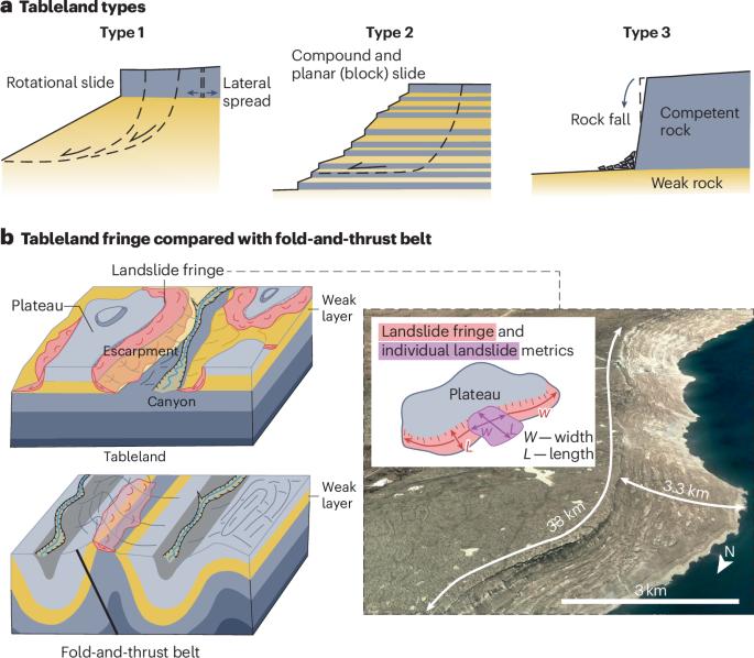
Abstract Image

Abstract Image

台地大型滑坡的发生、机理和危害
地球上最大的陆地聚合滑坡区,面积从几百平方公里到几千平方公里不等,都发生在地势相对较低的沉积台地和火山台地的边缘地带。然而,这些地区的滑坡识别困难重重,导致其发生频率和可能性被低估。在本综述中,我们将探讨发生在台地边缘的滑坡的全球分布、控制和动态。滑坡边缘是由于在较坚固的毛岩下面不间断地广泛存在软弱的次毛岩岩性所造成的。地形、悬崖高度和盖岩厚度不会影响滑坡的规模,但会在局部影响位移类型。旋转滑坡在大多数滑坡边缘占主导地位,最终会导致台地在百万年的时间尺度内消耗殆尽。一些台地边缘会产生灾难性的长距离岩崩或土流,进而引发海啸、河流崩塌或溃决性洪水。台地也可能因缓慢(每年几厘米)的滑坡运动而崩塌,足以对基础设施造成破坏。正如在西格陵兰岛观察到的那样,由于冰冻圈退化,这些危害在高纬度台地上日益严重。为了更好地量化这些潜在的危害,迫切需要更详细的全球滑坡边缘活动清单。
本文章由计算机程序翻译,如有差异,请以英文原文为准。
求助全文
约1分钟内获得全文 求助全文
来源期刊
自引率
0.00%
发文量
0
×
引用
GB/T 7714-2015
复制
MLA
复制
APA
复制
导出至
BibTeX EndNote RefMan NoteFirst NoteExpress
×
提示
您的信息不完整,为了账户安全,请先补充。
现在去补充
×
提示
您因"违规操作"
具体请查看互助需知
我知道了
×
提示
确定
请完成安全验证×
copy
已复制链接
快去分享给好友吧!
我知道了
右上角分享
点击右上角分享
0
联系我们:info@booksci.cn Book学术提供免费学术资源搜索服务,方便国内外学者检索中英文文献。致力于提供最便捷和优质的服务体验。 Copyright © 2023 布克学术 All rights reserved.
京ICP备2023020795号-1
ghs 京公网安备 11010802042870号
Book学术文献互助
Book学术文献互助群
群 号:481959085
Book学术官方微信